
File:Baku pipelines.svg

Size of this PNG preview of this SVG file: 800 × 463 pixels. Other resolutions: 320 × 185 pixels | 640 × 371 pixels | 1,024 × 593 pixels | 1,280 × 741 pixels | 2,560 × 1,482 pixels | 1,316 × 762 pixels.
Original file (SVG file, nominally 1,316 × 762 pixels, file size: 62 KB)
| This is a file from the Wikimedia Commons. Information from its description page there is shown below. Commons is a freely licensed media file repository. You can help. |
Summary
| Description |
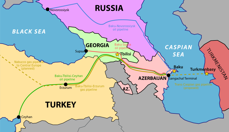
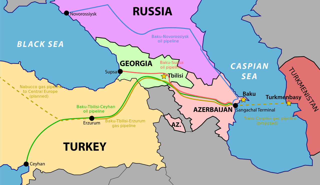
Norsk nynorsk: Kart over dei noverande og planlagde olje- og gassleidningane frå Baku. |
| Date | |
| Source | Own work |
| Author | Thomas Blomberg |
| Other versions |
File:Baku pipelines.svg has 2 translations.
|


Licensing
I, the copyright holder of this work, hereby publish it under the following licenses:
This file is licensed under the Creative Commons Attribution-Share Alike 3.0 Unported license.
- You are free:
- to share – to copy, distribute and transmit the work
- to remix – to adapt the work
- Under the following conditions:
- attribution – You must give appropriate credit, provide a link to the license, and indicate if changes were made. You may do so in any reasonable manner, but not in any way that suggests the licensor endorses you or your use.
- share alike – If you remix, transform, or build upon the material, you must distribute your contributions under the same or compatible license as the original.

|
Permission is granted to copy, distribute and/or modify this document under the terms of the GNU Free Documentation License, Version 1.2 or any later version published by the Free Software Foundation; with no Invariant Sections, no Front-Cover Texts, and no Back-Cover Texts. A copy of the license is included in the section entitled GNU Free Documentation License. |
You may select the license of your choice.
File history
Click on a date/time to view the file as it appeared at that time.
| Date/Time | Thumbnail | Dimensions | User | Comment | |
|---|---|---|---|---|---|
| current | 15:27, 16 September 2023 | | 1,316 × 762 (62 KB) | KajenCAT | File uploaded using svgtranslate tool (https://svgtranslate.toolforge.org/). Added translation for ca. |
| 10:00, 6 December 2015 |  | 1,316 × 762 (60 KB) | Geagea | Reverted to version as of 16:00, 6 March 2010 (UTC) | |
| 09:59, 6 December 2015 |  | 1,316 × 762 (60 KB) | Geagea | == {{int:filedesc}} == {{Information |Description={{en|1=Map of the existing and planned oil and gas pipelines from Baku.}} {{nn|1=Kart over dei noverande og planlagde olje- og gassleidningane frå Baku.}} |Source={{Ext... | |
| 16:00, 6 March 2010 |  | 1,316 × 762 (60 KB) | AteshCommons | Vector map of caucasus. AY Deezy graphic. | |
| 19:56, 10 August 2008 |  | 1,316 × 762 (456 KB) | Thomas Blomberg | {{Information |Description={{en|1=Map of the existing and planned oil and gas pipelines from Baku.}} |Source=Own work by uploader |Author=Thomas Blomberg |Date=2008-08-10 |Permission= |other_versions= }} {{ImageUpload|full}} [[Ca |
File usage
The following pages on the English Wikipedia use this file (pages on other projects are not listed):
- Azerbaijan
- Azerbaijan–Turkey relations
- Baku–Novorossiysk pipeline
- Baku–Supsa Pipeline
- Critical Foreign Dependencies Initiative
- Economy of Azerbaijan
- Heydar Aliyev
- History of Georgia (country)
- List of natural gas pipelines
- Petroleum industry in Azerbaijan
- Petroleum politics
- Pipelines in Azerbaijan
- Russo-Georgian War
- SOCAR
- Sangachal Terminal
- Second Nagorno-Karabakh War
- Trans-Caspian Gas Pipeline
- Transport in Azerbaijan
- User:Falcaorib
- User:Gunfighter~enwiki
- User:Nanobear~enwiki/SOWar temp
- User:Philip Habing/sandbox
- Portal:Georgia (country)
Global file usage
The following other wikis use this file:
- Usage on ar.wikipedia.org
- Usage on az.wikipedia.org
- Usage on be-tarask.wikipedia.org
- Usage on bg.wikipedia.org
- Usage on bs.wikipedia.org
- Usage on ca.wikipedia.org
- Usage on ce.wikipedia.org
- Usage on cs.wikipedia.org
- Usage on da.wikipedia.org
- Usage on de.wikipedia.org
- Usage on es.wikipedia.org
- Usage on et.wikipedia.org
- Usage on fa.wikipedia.org
- Usage on fi.wikipedia.org
- Usage on fr.wikipedia.org
- Usage on he.wikipedia.org
- Usage on hr.wikipedia.org
- Usage on hu.wikipedia.org
- Usage on hy.wikipedia.org
- Usage on it.wikipedia.org
View more global usage of this file.