
File:BottchersGap.png
No higher resolution available.
BottchersGap.png (336 × 336 pixels, file size: 189 KB, MIME type: image/png)
| This is a file from the Wikimedia Commons. Information from its description page there is shown below. Commons is a freely licensed media file repository. You can help. |
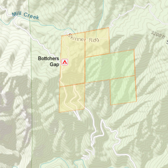
Summary
Map of land patents granted to John Bottcher in 1888 and 1890, the namesake of Bottchers Gap in Monterey County, California. Based on U.S. government sources.
Licensing
I, the copyright holder of this work, hereby publish it under the following license:
| This file is made available under the Creative Commons CC0 1.0 Universal Public Domain Dedication. | |
| The person who associated a work with this deed has dedicated the work to the public domain by waiving all of their rights to the work worldwide under copyright law, including all related and neighboring rights, to the extent allowed by law. You can copy, modify, distribute and perform the work, even for commercial purposes, all without asking permission.
|
File history
Click on a date/time to view the file as it appeared at that time.
| Date/Time | Thumbnail | Dimensions | User | Comment | |
|---|---|---|---|---|---|
| current | 05:47, 25 April 2020 | | 336 × 336 (189 KB) | Btphelps | Map of Bottchers Gap based on U.S. government sources |
File usage
The following pages on the English Wikipedia use this file (pages on other projects are not listed):