
File:Boucle verglas decembre-2013.gif
No higher resolution available.
Boucle_verglas_decembre-2013.gif (700 × 448 pixels, file size: 9.49 MB, MIME type: image/gif, looped, 38 frames, 9.5 s)
| This is a file from the Wikimedia Commons. Information from its description page there is shown below. Commons is a freely licensed media file repository. You can help. |
Summary
| Description |
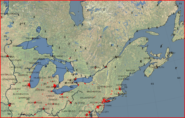
English: Surface map loop showing the pressure, snow areas (in white/blue), freezing rain area (in red) and the weather station icons for precipitation types from December 23, 03 UTC to decembre 24, 00 UTC for the 2013 Central and Eastern Canada ice storm.
Français : Carte météorologique montrant la pression et les zones de neige (blanc/bleu) et de pluie verglaçante du 20 décembre à 03 UTC au 24 décembre à 00 UTC durant le Verglas massif de décembre 2013 dans le nord-est de l'Amérique du Nord. |
| Date | |
| Source | Own work |
| Author | Pierre cb |
Licensing
I, the copyright holder of this work, hereby publish it under the following license:
| This file is made available under the Creative Commons CC0 1.0 Universal Public Domain Dedication. | |
| The person who associated a work with this deed has dedicated the work to the public domain by waiving all of their rights to the work worldwide under copyright law, including all related and neighboring rights, to the extent allowed by law. You can copy, modify, distribute and perform the work, even for commercial purposes, all without asking permission.
|
File history
Click on a date/time to view the file as it appeared at that time.
| Date/Time | Thumbnail | Dimensions | User | Comment | |
|---|---|---|---|---|---|
| current | 15:03, 31 December 2013 | | 700 × 448 (9.49 MB) | Pierre cb | Version plus petite en octets qui je l'espère permettera de régler le problème d'affichage. |
| 03:09, 30 December 2013 |  | 1,325 × 848 (11.99 MB) | Pierre cb | {{Information |Description ={{en|1=Surface map loop showing the pressure, snow areas (in white/blue), freezing rain area (in red) and the weather station icons for precipitation types from December 23, 03 UTC to decembre 24, 00 UTC for the [[:en:201... |
File usage
The following pages on the English Wikipedia use this file (pages on other projects are not listed):
Global file usage
The following other wikis use this file:
- Usage on fr.wikipedia.org
- Usage on si.wikipedia.org