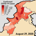
File:COVID-19 Pandemic Cases in Khyber Pakhtunkhwa by district.png

Page contents not supported in other languages.
This is a file from the Wikimedia Commons
Source: Wikipedia, the free encyclopedia.

Original file(3,840 × 3,840 pixels, file size: 934 KB, MIME type: image/png)

Summary

Description
English: This is a map showing the districts of Khyber Pakhtunkhwa, a province in Pakistan by the amount of COVID-19 Cases inside them. COVID-19 Case data has been taken from the KPK Health Department's Twitter Account and while they update their numbers daily, this map is updated only weekly. The template is my own and was created using maps and data from the Pakistan Bureau of Statistics. It follows the Mercator Projection.
This file's latest update reflects data for August 29, 2020, and the case data for that day is located here
Date
Source Own work
Author User:Abbasi786786

Licensing

I, the copyright holder of this work, hereby publish it under the following license:
w:en:Creative Commons
attribution share alike
This file is licensed under the Creative Commons Attribution-Share Alike 4.0 International license.
You are free:
  • to share – to copy, distribute and transmit the work
  • to remix – to adapt the work
Under the following conditions:
  • attribution – You must give appropriate credit, provide a link to the license, and indicate if changes were made. You may do so in any reasonable manner, but not in any way that suggests the licensor endorses you or your use.
  • share alike – If you remix, transform, or build upon the material, you must distribute your contributions under the same or compatible license as the original.

Captions

A map showing the provinces and territories of Pakistan by COVID-19 Cases

Items portrayed in this file

depicts

13 July 2020

image/png

fc169edcd2c9e1e5a0f473ca740999de0503e9cf

956,181 byte

3,840 pixel

3,840 pixel

File history

Click on a date/time to view the file as it appeared at that time.

Date/TimeThumbnailDimensionsUserComment
current22:48, 29 August 2020Thumbnail for version as of 22:48, 29 August 20203,840 × 3,840 (934 KB)Abbasi786786August 29, 2020: Swat District moves up one category
18:07, 10 August 2020Thumbnail for version as of 18:07, 10 August 20203,840 × 3,840 (1.05 MB)Abbasi786786August 10, 2020: No changes
15:13, 3 August 2020Thumbnail for version as of 15:13, 3 August 20203,840 × 3,840 (1.06 MB)Abbasi786786August 03, 2020: Lower Chitral District moves up one category
19:25, 27 July 2020Thumbnail for version as of 19:25, 27 July 20203,840 × 3,840 (1.17 MB)Abbasi786786July 27, 2020: No changes
16:13, 19 July 2020Thumbnail for version as of 16:13, 19 July 20203,840 × 3,840 (1.17 MB)Abbasi786786July 19, 2020
18:11, 13 July 2020Thumbnail for version as of 18:11, 13 July 20203,840 × 3,840 (1.17 MB)Abbasi786786Uploaded own work with UploadWizard
The following pages on the English Wikipedia use this file (pages on other projects are not listed):

Global file usage

The following other wikis use this file:

Metadata