
File:Circuito Permanente del Jarama 1980.svg

Size of this PNG preview of this SVG file: 800 × 576 pixels. Other resolutions: 320 × 230 pixels | 640 × 461 pixels | 1,024 × 737 pixels | 1,280 × 922 pixels | 2,560 × 1,844 pixels | 1,326 × 955 pixels.
Original file (SVG file, nominally 1,326 × 955 pixels, file size: 32 KB)
| This is a file from the Wikimedia Commons. Information from its description page there is shown below. Commons is a freely licensed media file repository. You can help. |
Summary
| Description |
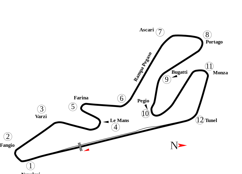
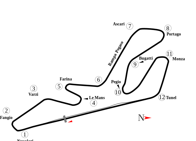
English: Track map of Circuito Permanente del Jarama, layout 1980-1989 . |
| Date | |
| Source | Own work |
| Author | AlexJ |
| Other versions |
|

| Camera location | | View this and other nearby images on: OpenStreetMap |
|---|
Licensing
| I, the copyright holder of this work, release this work into the public domain. This applies worldwide. In some countries this may not be legally possible; if so: I grant anyone the right to use this work for any purpose, without any conditions, unless such conditions are required by law. |
File history
Click on a date/time to view the file as it appeared at that time.
| Date/Time | Thumbnail | Dimensions | User | Comment | |
|---|---|---|---|---|---|
| current | AlexJ |Date=2010-01-05 |Permission= |other_ |
File usage
The following pages on the English Wikipedia use this file (pages on other projects are not listed):
- 1967 Spanish Grand Prix
- 1968 Spanish Grand Prix
- 1969 Madrid Grand Prix
- 1970 Spanish Grand Prix
- 1972 Spanish Grand Prix
- 1974 Spanish Grand Prix
- 1976 Spanish Grand Prix
- 1977 Spanish Grand Prix
- 1977 Spanish motorcycle Grand Prix
- 1978 Spanish Grand Prix
- 1978 Spanish motorcycle Grand Prix
- 1979 Spanish Grand Prix
- 1979 Spanish motorcycle Grand Prix
- 1980 Spanish Grand Prix
- 1980 Spanish motorcycle Grand Prix
- 1981 Spanish Grand Prix
- 1982 Spanish motorcycle Grand Prix
- 1983 Gran Premio de Madrid
- 1983 Spanish motorcycle Grand Prix
- 1984 Spanish motorcycle Grand Prix
- 1985 Spanish motorcycle Grand Prix
- 1986 Spanish motorcycle Grand Prix
- 1987 360 km of Jarama
- 1987 Jarama 4 Hours
- 1987 Portuguese motorcycle Grand Prix
- 1988 360 km of Jarama
- 1988 Spanish motorcycle Grand Prix
- 1989 480 km of Jarama
- Circuito del Jarama
- List of FIA World Touring Car Championship circuits
- List of Formula One circuits
- List of World Sportscar Championship circuits
- Portuguese motorcycle Grand Prix
- Spanish Grand Prix
- Spanish motorcycle Grand Prix
- User talk:4u1e/archive8
- User talk:Antiuser/Archive 5
- User talk:Apterygial/Archive 8
- User talk:Beardybloke
- User talk:Bjmullan/Archive WPF1
- User talk:Carloseduardo~enwiki/Archive/2011
- User talk:Cdhaptomos/Archive 3
- User talk:Clyde1998/Archive/2011
- User talk:Cs-wolves/Archive 10
- User talk:Donnie Park/Archive 6
- User talk:Jamesontai/Archive 8
- User talk:Jasonauk/Archive/2011
- User talk:Kevintjeerdsma1996
- User talk:Midgrid/Archive 12
- User talk:NapHit/Archive 5
- User talk:Schumi555/archive5
- User talk:Sporti/Archive 3
- User talk:The359/Archive 7
- User talk:Thelb4/Archive 7
- User talk:Trekphiler/Archive 5
- User talk:Typ932/Archive 8
- User talk:Wild mine/Archive 4
- User talk:WilliamF1two/April 2010 to May 2011
- Wikipedia:WikiProject Formula One/Newsletter/201104
Global file usage
The following other wikis use this file:
- Usage on ar.wikipedia.org
- جائزة إسبانيا الكبرى 1967
- جائزة إسبانيا الكبرى 1968
- جائزة إسبانيا الكبرى 1970
- جائزة إسبانيا الكبرى 1972
- جائزة إسبانيا الكبرى 1974
- جائزة إسبانيا الكبرى 1976
- جائزة إسبانيا الكبرى 1977
- جائزة إسبانيا الكبرى 1978
- جائزة إسبانيا الكبرى 1979
- جائزة إسبانيا الكبرى 1981
- جائزة إسبانيا الكبرى للدراجات النارية 1988
- Usage on bg.wikipedia.org
- Голяма награда на Испания
- 1981 Голяма награда на Испания
- 1979 Голяма награда на Испания
- 1978 Голяма награда на Испания
- 1977 Голяма награда на Испания
- 1968 Голяма награда на Испания
- 1976 Голяма награда на Испания
- 1970 Голяма награда на Испания
- 1972 Голяма награда на Испания
- 1974 Голяма награда на Испания
- Usage on br.wikipedia.org
- Usage on cs.wikipedia.org
- Usage on de.wikipedia.org
- Großer Preis von Portugal (Motorrad)
- Großer Preis von Spanien 1970
- Großer Preis von Spanien 1972
- Großer Preis von Spanien 1968
- Großer Preis von Spanien 1974
- Großer Preis von Spanien 1976
- Großer Preis von Spanien 1977
- Großer Preis von Spanien 1978
- Großer Preis von Spanien 1979
- Großer Preis von Spanien 1981
- 480-km-Rennen von Jarama 1989
- Usage on es.wikipedia.org
View more global usage of this file.