
Search results
There is a page named "File:Colonisation 1660.png" on Wikipedia
 DescriptionColonisation 1660.png Map of major world powers by year, derived from public domain animated map on wikipedia. As the orriginal licence of...(4,000 × 1,754 (1.13 MB)) - 20:47, 3 April 2024
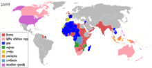 Repositioned image and fixed colours to match other maps in the 'Colonisation' series (1492, 1550, 1660, 1754, 1800, 1822, 1885, 1914, 1938, 1959, 1974, 2007) -...(1,438 × 638 (3.51 MB)) - 21:19, 1 April 2024
 DescriptionColonisation 1822.png Map of major world powers by year, derived from public domain animated map on wikipedia. As the orriginal licence of...(1,425 × 625 (21 KB)) - 21:17, 1 April 2024
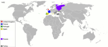 DescriptionColonisation 1492.png Map of major world powers by year Date 22 March 2007 Source public domain animated map by ArdadN here Author ArdadN...(3,600 × 1,578 (1.09 MB)) - 21:17, 1 April 2024
 DescriptionColonisation 1754.png Map of major world powers by year, derived from public domain animated map on wikipedia. As the orriginal licence of...(1,799 × 789 (144 KB)) - 21:17, 1 April 2024
 DescriptionColonisation 1812.png English: Colonial empires in 1812 Français : Empires coloniaux en 1812 Español: Imperios coloniales en 1812 Português:...(1,357 × 628 (16 KB)) - 21:17, 1 April 2024
 DescriptionColonisation 1885.png Map of major world powers by year, derived from public domain animated map on wikipedia. As the orriginal licence of...(1,200 × 526 (206 KB)) - 21:17, 1 April 2024
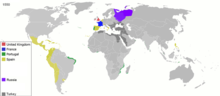 DescriptionColonisation 1550.png Map of major world powers by year As the orriginal licence of the animation was Public Domain, this image which has been...(3,600 × 1,578 (1.14 MB)) - 21:17, 1 April 2024
 DescriptionColonisation 1600.png English: Colonisation for 1600. Date 4 April 2020 Source Own work Author Каракорум...(8,550 × 3,750 (3.41 MB)) - 21:17, 1 April 2024
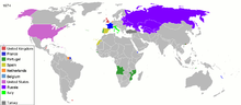 DescriptionColonisation 1974.png Map of major world powers by year, derived from public domain animated map on wikipedia. As the orriginal licence of...(1,425 × 625 (37 KB)) - 21:17, 1 April 2024
 DescriptionColonisation 1938.png Map of major world powers by year, derived from public domain animated map on wikipedia. As the original licence of the...(1,425 × 625 (52 KB)) - 21:17, 1 April 2024
 DescriptionColonisation 2007.png Map of major world powers by year, derived from public domain animated map on wikipedia. As the orriginal licence of...(1,425 × 625 (44 KB)) - 21:17, 1 April 2024
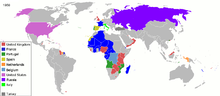 DescriptionColonisation 1959.png Map of major world powers by year, derived from public domain animated map on wikipedia. As the orriginal licence of...(1,425 × 625 (37 KB)) - 21:17, 1 April 2024
 conteúdo projeto EPTrilhas, derivative work by Colonisation 1660.png, derivative work by Colonisation 1754, derivative work by World 1898 empires colonies...(1,080 × 4,422 (663 KB)) - 21:10, 1 April 2024
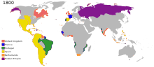
 DescriptionColonisation 1800.png English: Colonial empires in 1800 Français : Empires coloniaux en 1800 Español: Imperios coloniales en 1800 Português:...(1,425 × 625 (42 KB)) - 11:50, 21 July 2024
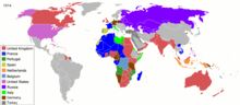 DescriptionColonisation 1914.png Map of major world powers by year, derived from public domain animated map on wikipedia. As the orriginal licence of...(1,425 × 625 (51 KB)) - 21:17, 1 April 2024
 DescriptionColonisation 2022.png Map of major world powers by year, derived from public domain animated map on wikipedia. As the orriginal licence of...(1,425 × 625 (47 KB)) - 22:16, 1 April 2024
- DescriptionColonisation territorial changes from 15th to 20th century.ogv English: Colonisation territorial changes from 15th to 20th century Ελληνικά:...(Ogg Theora video file, 1 min 34 s) - 19:52, 7 February 2024
 retouched picture, which means that it has been digitally altered from its original version. The original can be viewed here: Colonisation 1800.png: . ...(1,425 × 625 (228 KB)) - 21:04, 1 April 2024
 Pays membres de l'OTAN Autres pays alliés des États-Unis Pays colonisés Pays membres du pacte de Varsovie Autres pays alliés de l’URSS Pays...(940 × 477 (853 KB)) - 06:25, 22 April 2024


