
File:Colorado county map highlighting 14 counties affected by 2013 flooding.jpg

Size of this preview: 800 × 579 pixels. Other resolutions: 320 × 232 pixels | 640 × 463 pixels | 1,024 × 741 pixels | 1,280 × 926 pixels | 2,000 × 1,447 pixels.
Original file (2,000 × 1,447 pixels, file size: 536 KB, MIME type: image/jpeg)
| This is a file from the Wikimedia Commons. Information from its description page there is shown below. Commons is a freely licensed media file repository. You can help. |

|
This incident map image could be re-created using vector graphics as an SVG file. This has several advantages; see Commons:Media for cleanup for more information. If an SVG form of this image is available, please upload it and afterwards replace this template with
{{vector version available|new image name}}.
It is recommended to name the SVG file “Colorado county map highlighting 14 counties affected by 2013 flooding.svg”—then the template Vva ) does not need the new image name parameter. |


| Description |
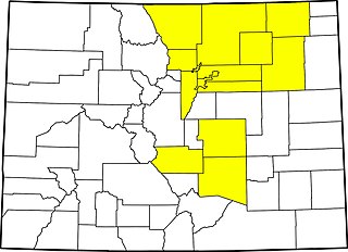
English: County map of Colorado highlighting 14 counties declared disaster emergencies on September 13, 2013 by governor in 2013 Colorado flooding: Adams, Arapahoe, Broomfield, Boulder, Denver, El Paso, Fremont, Jefferson, Larimer, Logan, Morgan, Pueblo, Washington and Weld. |
||
| Date | Based on information current as of September 13, 2013 | ||
| Source | Modification by uploader of File:Map of Colorado counties, blank.svg | ||
| Author | Source file by Augiasstallputzer~commonswiki | ||
| Permission (Reusing this file) |
|
File history
Click on a date/time to view the file as it appeared at that time.
| Date/Time | Thumbnail | Dimensions | User | Comment | |
|---|---|---|---|---|---|
| current | 16:53, 16 September 2013 | | 2,000 × 1,447 (536 KB) | Postdlf | {{Information |Description={{en|County map of {{w|Colorado}} highlighting 14 counties declared disaster emergencies on September 13, 2013 by governor in {{w|2013 Colorado flooding}}: Adams, Arapahoe, Broomfield, Boulder, Denver, El Paso, Fremont, Jeffe... |
File usage
The following pages on the English Wikipedia use this file (pages on other projects are not listed):
Global file usage
The following other wikis use this file:
- Usage on es.wikipedia.org