
File:Cte cachamay aereo.jpg

Size of this preview: 800 × 512 pixels. Other resolutions: 320 × 205 pixels | 640 × 410 pixels | 1,024 × 655 pixels | 1,280 × 819 pixels | 1,600 × 1,024 pixels.
Original file (1,600 × 1,024 pixels, file size: 464 KB, MIME type: image/jpeg)
| This is a file from the Wikimedia Commons. Information from its description page there is shown below. Commons is a freely licensed media file repository. You can help. |
Summary
| Description |
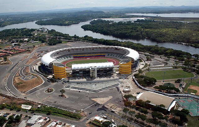
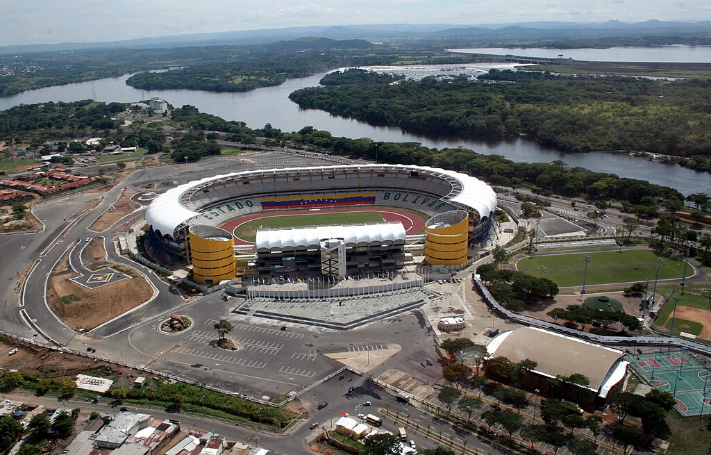
English: Aerial loca view of CTE Cachamay (center), Following clockwise: the alternating field (Cachamaicito), the softball field, basketball courts and the Hermanas González Gym. At the background is La Llovizna Park, Macagua Power Station and the Cachamay Park.
Español: Vista Aérea del CTE Cachamay (centro), siguiendo el sentido de las agujas del reloj, se ubica el campo alterno (Cachamaicito), la cancha de sóftbol, baloncesto y el gimnasio Hermanas González. En el fondo se observa al Parque La Llovizna, la Central Hidroeléctrica Macagua y el Parque Cachamay.
Français : Vue aérienne sur le centre sportif CTE Cachamay. Dans le sens d'une aiguille du monde : le terrein de Cachamaicito, le terrain de softball, le centre de basket et le gymnase Hermanas González. En arrière-plan, les parcs de La Llovizna et de Cachamay, et la centrale hydroélectrique de Macagua. |
| Date | |
| Source | Own work |
| Author | Shaolingv4 |
| Camera location | | View this and other nearby images on: OpenStreetMap |
|---|
Licensing
I, the copyright holder of this work, hereby publish it under the following licenses:

|
Permission is granted to copy, distribute and/or modify this document under the terms of the GNU Free Documentation License, Version 1.2 or any later version published by the Free Software Foundation; with no Invariant Sections, no Front-Cover Texts, and no Back-Cover Texts. A copy of the license is included in the section entitled GNU Free Documentation License. |
This file is licensed under the Creative Commons Attribution-Share Alike 4.0 International, 3.0 Unported, 2.5 Generic, 2.0 Generic and 1.0 Generic license.
- You are free:
- to share – to copy, distribute and transmit the work
- to remix – to adapt the work
- Under the following conditions:
- attribution – You must give appropriate credit, provide a link to the license, and indicate if changes were made. You may do so in any reasonable manner, but not in any way that suggests the licensor endorses you or your use.
- share alike – If you remix, transform, or build upon the material, you must distribute your contributions under the same or compatible license as the original.
You may select the license of your choice.

|
This image has been assessed under the valued image criteria and is considered the most valued image on Commons within the scope: Polideportivo Cachamay Stadium, Guayana City (general view). You can see its nomination here. |
File history
Click on a date/time to view the file as it appeared at that time.
| Date/Time | Thumbnail | Dimensions | User | Comment | |
|---|---|---|---|---|---|
| current | 18:19, 24 March 2008 | | 1,600 × 1,024 (464 KB) | Shaolingv4~commonswiki | {{Information |Description= Vista Aérea del CTE Cachamay // Aerial view of CTE Cachamay |Source=self-made |Date=2007-10-18 |Author= Shaolingv4 |Permission= |other_versions= }} |
File usage
The following pages on the English Wikipedia use this file (pages on other projects are not listed):
Global file usage
The following other wikis use this file:
- Usage on ar.wikipedia.org
- Usage on ast.wikipedia.org
- Usage on ca.wikipedia.org
- Usage on de.wikipedia.org
- Usage on es.wikipedia.org
- Usage on fa.wikipedia.org
- Usage on fi.wikipedia.org
- Usage on fr.wikipedia.org
- Usage on hr.wikipedia.org
- Usage on hy.wikipedia.org
- Usage on it.wikipedia.org
- Usage on ka.wikipedia.org
- Usage on nl.wikipedia.org
- Usage on no.wikipedia.org
- Usage on pt.wikipedia.org
- Usage on ru.wikipedia.org
- Usage on sh.wikipedia.org
- Usage on sr.wikipedia.org
- Usage on sv.wikipedia.org
- Usage on tr.wikipedia.org
- Usage on uk.wikipedia.org
- Usage on vep.wikipedia.org
- Usage on www.wikidata.org
- Usage on zh.wikipedia.org