
File:Danger sign above Cwm Graig Ddu - geograph.org.uk - 157591.jpg
No higher resolution available.
Danger_sign_above_Cwm_Graig_Ddu_-_geograph.org.uk_-_157591.jpg (640 × 480 pixels, file size: 64 KB, MIME type: image/jpeg)
| This is a file from the Wikimedia Commons. Information from its description page there is shown below. Commons is a freely licensed media file repository. You can help. |
Summary
| Description |
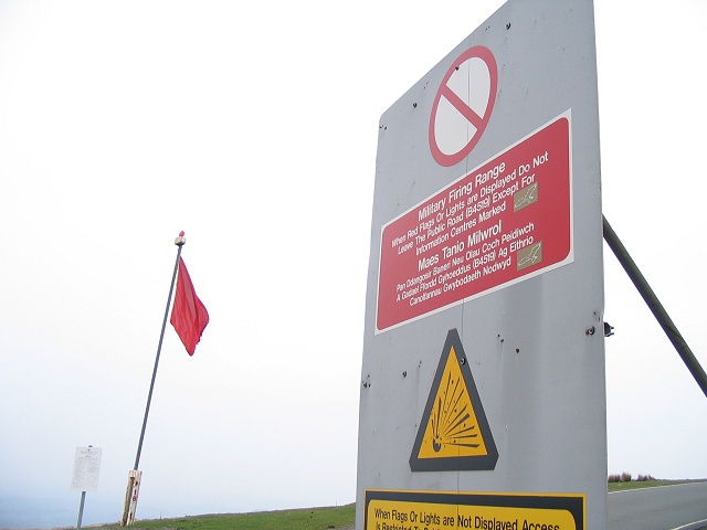
English: Danger sign above Cwm Graig Ddu As you drive southwest onto the road across the Sennybridge artillery range you will see this sign by the cattle grid and lookout point.
On days when the red flag is on display you must stick to the road and not go walking around on the mountain. |
| Date | |
| Source | From geograph.org.uk |
| Author | Nigel Davies |
| Attribution (required by the license) | Nigel Davies / Danger sign above Cwm Graig Ddu / |
| Object location | | View this and other nearby images on: OpenStreetMap |
|---|
_heading:45.00&language=en)
Licensing

|
This image was taken from the
Creative Commons Attribution-ShareAlike 2.0 license. |
This file is licensed under the Creative Commons Attribution-Share Alike 2.0 Generic license.
Attribution: Nigel Davies
- You are free:
- to share – to copy, distribute and transmit the work
- to remix – to adapt the work
- Under the following conditions:
- attribution – You must give appropriate credit, provide a link to the license, and indicate if changes were made. You may do so in any reasonable manner, but not in any way that suggests the licensor endorses you or your use.
- share alike – If you remix, transform, or build upon the material, you must distribute your contributions under the same or compatible license as the original.
- Remove redundant categories and try to put this image in the most specific category/categories
- Remove this template
- The location categories are based on information from this geonames tool and this OpenStreetMap tool combined with a database. You can also have a look at this tool from mysociety.
- The topic category from Geograph was Sign (find similar images at Geograph)
File history
Click on a date/time to view the file as it appeared at that time.
| Date/Time | Thumbnail | Dimensions | User | Comment | |
|---|---|---|---|---|---|
| current | 07:31, 31 January 2010 | | 640 × 480 (64 KB) | GeographBot | == {{int:filedesc}} == {{Information |description={{en|1=Danger sign above Cwm Graig Ddu As you drive southwest onto the road across the Sennybridge artillery range you will see this sign by the cattle grid and lookout point. On days when the red flag is |
File usage
The following pages on the English Wikipedia use this file (pages on other projects are not listed):