
Search results
Did you mean: File:dardanelles
The page "File:Dardanelle" does not exist. You can ask for it to be uploaded, but consider checking the search results below to see whether the topic is already covered.
 English 1909 Sanborn Fire Map segment showing the location of the Dardanelle pontoon bridge. determination method: SHA-1...(3,012 × 1,800 (641 KB)) - 02:29, 20 June 2024
 French Vuë du détroit des Dardanelles. German Prospect der Meer-Enge bey den Dardanellen Italian Vista dello Stretto di Dardanelle Latin Freti Dardanellorum...(5,590 × 4,180 (3.15 MB)) - 12:35, 30 November 2022
 USGS topographical map segment showing transportation routes available in the Russellville and Dardanelle area of Arkansas determination method: SHA-1...(1,045 × 786 (367 KB)) - 07:21, 8 April 2023
 los Dardanelos Map of the Dardanelles. Modified version of Image:Dardanelles map.png Image history of en:Image:Dardanelles map2.png: (del) (cur) 23:48...(700 × 600 (123 KB)) - 02:30, 20 June 2024
 Postal Address: 101 S Front St, Dardanelle, AR 72834, USA I, the copyright holder of this work, hereby publish it under the following license: This file...(3,625 × 2,647 (42.27 MB)) - 12:40, 3 January 2023
 4 March 2023 English 1907 shipment of cotton on D&RR from Dardanelle, Arkansas author name string: Mike Goad operator: Flickr described at URL: https://www...(1,057 × 690 (163 KB)) - 10:07, 20 July 2024
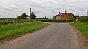 Attribution-Share Alike 2.0 Generic license. Attribution: Road junction adjacent to Dardanelle House by Mick Garratt You are free: to share – to copy, distribute and...(640 × 360 (65 KB)) - 01:20, 21 June 2023
 22 April 2024 English 1877 Map shows Dardanelle and Norristown on the Arkansas River as well as roads, properties, and geographic features. Flickr user...(3,339 × 5,116 (6.87 MB)) - 10:44, 9 July 2024
 carte du détroit des Dardanelles (Turquie) *'''Source''' : fond de carte vierge [[:Image:Dardanelles map.png|Image:Dardanelles map.png]] provenant de...(1,020 × 980 (633 KB)) - 02:29, 20 June 2024
 https://creativecommons.org/publicdomain/mark/1.0/PDMCreative Commons Public Domain Mark 1.0falsefalse English Strait of the Dardanelles...(3,012 × 3,854 (2.31 MB)) - 08:20, 5 December 2023
 English 1901 maps of The Dardanelles and the Troad and The Bosphorus and Constantinople Vietnamese 1901 bản đồ của Dardanelles và Đội quân và Bosphorus...(8,657 × 6,820 (11.09 MB)) - 04:20, 3 April 2023
 English Ottoman torpedoboat Kütahya in Dardanelles during the Balkan War of 1913. Hamidiye is visible in the background....(1,554 × 564 (483 KB)) - 00:30, 7 October 2020
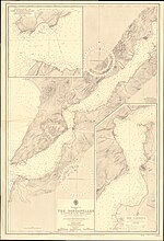 English Nautical chart of the Dardanelles...(11,098 × 16,273 (62.08 MB)) - 20:35, 14 April 2024
 English 1840 Admiralty chart - Asia Minor, Entrance of the Dardanelles, with the Plain of Troy and Tenedos determination method: SHA-1...(4,469 × 6,000 (54.87 MB)) - 16:02, 26 April 2024
 English World War I map of the Sea of Marmara, the Dardanelles and the Bosphorus...(7,767 × 6,272 (139.38 MB)) - 12:41, 23 September 2023
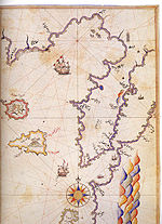 wikipedia. 2006-10-30 00:18 Shuppiluliuma 600×826× (180304 bytes) [[Dardanelles|Dardanelles Strait]] and the [[Saros_Bay|Gulf of Saros]] on the Kitab-ı Bahriye...(600 × 826 (176 KB)) - 02:29, 20 June 2024
 English Seaplane being towed in the Dardanelles 1915...(848 × 587 (96 KB)) - 08:06, 27 May 2024
 English 1915 Australian maps of Gallipolli, the Dardanelles and the Sea of Marmara determination method: SHA-1...(5,000 × 6,783 (21.18 MB)) - 15:10, 3 April 2023
 English French La flotte au mouillage aux Dardanelles...(1,905 × 1,376 (124 KB)) - 03:56, 3 December 2022
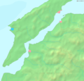 Map of the w:en:Dardanelles strait. Bounding box West 26.15°, South 39.95°, East 26.9°, North 40.5°. English determination method: SHA-1...(1,020 × 980 (219 KB)) - 02:30, 20 June 2024


- as a result of this war Russia in control of Constantinople and the Dardanelles, and thus gain a free access to the warm waters of the Mediterranean