
File:DeltaOkawango.jpg

Size of this preview: 745 × 600 pixels. Other resolutions: 298 × 240 pixels | 596 × 480 pixels | 790 × 636 pixels.
Original file (790 × 636 pixels, file size: 113 KB, MIME type: image/jpeg)
| This is a file from the Wikimedia Commons. Information from its description page there is shown below. Commons is a freely licensed media file repository. You can help. |
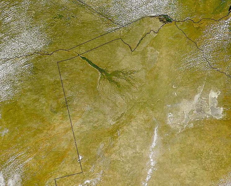
| Description | Okavango Delta | ||||
| Date | |||||
| Source | Part of http://visibleearth.nasa.gov/view_rec.php?id=1260 picture ("Visible Earth") :Sensor OrbView-2/SeaWiFS :Datastart 1999-03-28 :Visible Earth v1 ID 4972 | ||||
| Author | The SeaWiFS Project, NASA/Goddard Space Flight Center, and ORBIMAGE | ||||
| Permission (Reusing this file) |
|
||||
| Other versions |
 |
File history
Click on a date/time to view the file as it appeared at that time.
| Date/Time | Thumbnail | Dimensions | User | Comment | |
|---|---|---|---|---|---|
| current | 13:53, 19 April 2005 | | 790 × 636 (113 KB) | Julo | Okavango Delta Part of http://visibleearth.nasa.gov/view_rec.php?id=1260 picture ("Visible Earth") :Sensor OrbView-2/SeaWiFS :Datastart 1999-03-28 :Visible Earth v1 ID 4972 :Visualization Date 1999-03-28 {{PD-USGov-NASA}} |
File usage
The following pages on the English Wikipedia use this file (pages on other projects are not listed):
Global file usage
The following other wikis use this file:
- Usage on af.wikipedia.org
- Usage on ar.wikipedia.org
- Usage on be.wikipedia.org
- Usage on bn.wikipedia.org
- Usage on ca.wikipedia.org
- Usage on ceb.wikipedia.org
- Usage on de.wikipedia.org
- Usage on el.wikipedia.org
- Usage on eo.wikipedia.org
- Usage on es.wikipedia.org
- Usage on fa.wikipedia.org
- Usage on fi.wikipedia.org
- Usage on gl.wikipedia.org
- Usage on ha.wikipedia.org
- Usage on he.wikipedia.org
- Usage on hu.wikipedia.org
- Usage on hy.wikipedia.org
- Usage on it.wikipedia.org
- Usage on ja.wikipedia.org
- Usage on ka.wikipedia.org
- Usage on lt.wikipedia.org
- Usage on ml.wikipedia.org
- Usage on mt.wikipedia.org
- Usage on nl.wikipedia.org
- Usage on pl.wikipedia.org
- Usage on pnb.wikipedia.org
- Usage on pt.wikipedia.org
- Usage on ro.wikipedia.org
- Usage on ru.wikipedia.org
- Usage on sl.wikipedia.org
- Usage on sv.wikipedia.org
- Usage on sw.wikipedia.org
View more global usage of this file.