
File:Descobrimentos e explorações portuguesesV2.png

Size of this preview: 800 × 370 pixels. Other resolutions: 320 × 148 pixels | 640 × 296 pixels | 1,357 × 628 pixels.
Original file (1,357 × 628 pixels, file size: 211 KB, MIME type: image/png)
| This is a file from the Wikimedia Commons. Information from its description page there is shown below. Commons is a freely licensed media file repository. You can help. |
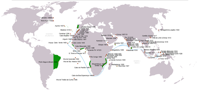
- English: Portuguese discoveries & explorations V2
| Description |
|
| Date | (UTC) |
| Source | |
| Author |
|
| Permission (Reusing this file) |
Creative Commons Attribution-Share Alike 3.0 Unported license |
| Other versions | (en) File:Portuguese discoveries and explorationsV2en.png |
| This is a retouched picture, which means that it has been digitally altered from its original version. Modifications: searoutes and dates corrected. The original can be viewed here: Descobrimentos e explorações portugueses.png: File:Descobrimentos e explorações portugueses.png. Modifications made by Uxbona.
|
I, the copyright holder of this work, hereby publish it under the following license:

|
Permission is granted to copy, distribute and/or modify this document under the terms of the GNU Free Documentation License, Version 1.2 or any later version published by the Free Software Foundation; with no Invariant Sections, no Front-Cover Texts, and no Back-Cover Texts. A copy of the license is included in the section entitled GNU Free Documentation License. |
| This file is licensed under the Creative Commons Attribution-Share Alike 3.0 Unported license. | ||
| ||
| This licensing tag was added to this file as part of the GFDL licensing update. |
Original upload log
This image is a derivative work of the following images:
- File:Descobrimentos_e_explorações_portugueses.png licensed with GFDL
Uploaded with derivativeFX
File history
Click on a date/time to view the file as it appeared at that time.
| Date/Time | Thumbnail | Dimensions | User | Comment | |
|---|---|---|---|---|---|
| current | 22:30, 13 June 2011 | | 1,357 × 628 (211 KB) | Uxbona | (Corrigida posição do reino do Sião/Tailândia; Acrescentar chegadas a Pegu, Sumatra e Cochinchina (Da Nang) ) |
| 22:44, 10 June 2011 |  | 1,357 × 628 (211 KB) | Uxbona | actualização | |
| 22:41, 10 June 2011 |  | 1,357 × 628 (211 KB) | Uxbona | actualização;correcção | |
| 13:37, 10 June 2011 |  | 1,357 × 628 (211 KB) | Uxbona | Corrigida posição do reino do Sião/Tailândia; Acrescentar chegadas a Pegu, Sumatra e Cochinchina (Da Nang) | |
| 12:02, 11 April 2010 |  | 1,357 × 628 (208 KB) | Uxbona | Completar dados, reduzir área de influência em África no reinado de D. João III (c.1536) | |
| 10:11, 10 June 2009 |  | 1,357 × 628 (206 KB) | Uxbona | Datad corrigidas | |
| 21:42, 8 June 2009 |  | 1,357 × 628 (206 KB) | Uxbona | acrescentar dados ( Reino do Sião) | |
| 18:23, 7 June 2009 |  | 1,357 × 628 (205 KB) | Uxbona | Reverted to version as of 16:09, 7 June 2009 | |
| 18:21, 7 June 2009 |  | 1,357 × 628 (204 KB) | Uxbona | English version | |
| 16:09, 7 June 2009 |  | 1,357 × 628 (205 KB) | Uxbona | {{Information |Description=Portuguese discoveries and explorations, sea routes |Source=*File:Descobrimentos_e_explorações_portugueses.png |Date=2009-06-07 17:07 (UTC) |Author=*File:Descobrimentos_e_explorações_portugueses.png: *[[:File:Por |
File usage
The following pages on the English Wikipedia use this file (pages on other projects are not listed):
Global file usage
The following other wikis use this file:
- Usage on ar.wikipedia.org
- Usage on ast.wikipedia.org
- Usage on bg.wikipedia.org
- Usage on bn.wikipedia.org
- Usage on ca.wikipedia.org
- Usage on cs.wikipedia.org
- Usage on es.wikipedia.org
- Usage on fr.wikipedia.org
- Usage on gl.wikipedia.org
- Usage on it.wikipedia.org
- Usage on ja.wikipedia.org
- Usage on la.wikipedia.org
- Usage on mwl.wikipedia.org
- Usage on nl.wikipedia.org
- Usage on pt.wikipedia.org
- Usage on uk.wikipedia.org
- Usage on vi.wikipedia.org
- Usage on zh.wikipedia.org