
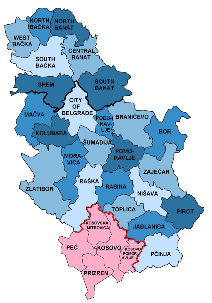
File:Districts of Serbia.png

Size of this preview: 420 × 599 pixels. Other resolutions: 168 × 240 pixels | 336 × 480 pixels | 538 × 768 pixels | 717 × 1,024 pixels | 1,824 × 2,603 pixels.
Original file (1,824 × 2,603 pixels, file size: 445 KB, MIME type: image/png)
| This is a file from the Wikimedia Commons. Information from its description page there is shown below. Commons is a freely licensed media file repository. You can help. |

Summary
.png)
.png)


.png)
Licensing
| I, the copyright holder of this work, release this work into the public domain. This applies worldwide. In some countries this may not be legally possible; if so: I grant anyone the right to use this work for any purpose, without any conditions, unless such conditions are required by law. |
Original upload log
This image is a derivative work of the following images:
- File:Disricts_of_Serbia_by_population_density.svglicensed with PD-self
- 2010-04-25T18:39:42Z Алексей Глушков 765x1060 (47381 Bytes) {{Information |Description={{en|1=Map of disricts of Serbia by population density}} {{sr|1=Карта округа Србија на густини становништва}} |Source=Own work |Author=Gajmar at [http://ru.wiki
Uploaded with derivativeFX
File history
Click on a date/time to view the file as it appeared at that time.
| Date/Time | Thumbnail | Dimensions | User | Comment | |
|---|---|---|---|---|---|
| current | 08:02, 24 February 2022 | | 1,824 × 2,603 (445 KB) | Túrelio | Reverted to version as of 11:37, 2 October 2021 (UTC), as violation of COM:OW |
| 20:10, 14 January 2022 |  | 1,824 × 2,603 (589 KB) | TómasdeAquino2 | stable version per file name | |
| 11:37, 2 October 2021 |  | 1,824 × 2,603 (445 KB) | InNeed95 | Reverted to version as of 19:42, 29 September 2021 (UTC) /// Rv. Sock-Acc. POV-Push. / Vandlism | |
| 06:35, 30 September 2021 |  | 1,824 × 2,603 (589 KB) | Aquinasthomes1 | Reverted to version as of 03:42, 26 September 2021 (UTC) Revert Vandalism | |
| 19:42, 29 September 2021 |  | 1,824 × 2,603 (445 KB) | InNeed95 | Reverted to version as of 13:20, 6 August 2021 (UTC) /// Rv. Sock-Acc. POV-Push. | |
| 03:42, 26 September 2021 |  | 1,824 × 2,603 (589 KB) | Aquinasthomes1 | minor fix in contour | |
| 02:53, 26 September 2021 |  | 1,824 × 2,603 (458 KB) | Aquinasthomes1 | Reverted to version as of 22:39, 31 May 2015 (UTC). Per alternative image | |
| 13:20, 6 August 2021 |  | 1,824 × 2,603 (445 KB) | InNeed95 | Reverted to version as of 21:27, 31 May 2015 (UTC) Consensus. Showing the disputed status of Kosovo. (Districts in Kosovo are also shown as claimed by serbia) /// Its better to have one single map instead of many different ones. (Adding that the other maps are not in use at all compared to this one) | |
| 22:39, 31 May 2015 |  | 1,824 × 2,603 (458 KB) | Anastan | We already have that file File:Districts_of_Serbia_(Kosovo_disputed).png | |
| 21:27, 31 May 2015 |  | 1,824 × 2,603 (445 KB) | VS6507 | consensus version |
File usage
The following pages on the English Wikipedia use this file (pages on other projects are not listed):
Global file usage
The following other wikis use this file:
- Usage on ca.wikipedia.org
- Usage on cs.wikipedia.org
- Usage on el.wikipedia.org
- Usage on es.wikipedia.org
- Usage on fa.wikipedia.org
- Usage on fi.wikipedia.org
- Usage on frr.wikipedia.org
- Usage on fr.wikipedia.org
- Usage on id.wikipedia.org
- Usage on lt.wikipedia.org
- Usage on mzn.wikipedia.org
- Usage on or.wikipedia.org
- Usage on pl.wikipedia.org
- Usage on pnb.wikipedia.org
- Usage on ps.wikipedia.org
- Usage on ro.wikipedia.org
- Usage on sco.wikipedia.org
- Usage on sh.wikipedia.org
- Usage on sv.wikipedia.org
- Usage on th.wikipedia.org
- Usage on tr.wikipedia.org
- Usage on ur.wikipedia.org
- Usage on vec.wikipedia.org
- Usage on vi.wikipedia.org