
File:Dolomiti di Brenta.jpg

Size of this preview: 800 × 529 pixels. Other resolutions: 320 × 212 pixels | 640 × 423 pixels | 1,022 × 676 pixels.
Original file (1,022 × 676 pixels, file size: 315 KB, MIME type: image/jpeg)
| This is a file from the Wikimedia Commons. Information from its description page there is shown below. Commons is a freely licensed media file repository. You can help. |
Summary
| Description |
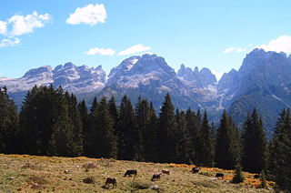
English: Dolomiti di Brenta, seen from the region south of Madonna di Campiglio (Italy). Mountains and passes (bocc(hett)e) from left to right: Cima Grostè 2898m, Bocca dei Camosci 2774m, Campanile dei Camosci 2914m, after Bocchetta Alta Cima Falkner 2988m (in front Castello di Vallesinella 2782m). Campanile di Vallesinella 2940m (in front Castelletto Superiore 2664m), Rocca della Val Perse 2894m, Cima Sella 2917m. Pass Bocca del Tuckett 2649m. Cima Brenta (3151m) hidden behind Cima occidentale di Brenta 3124m. Left in front Campanili di Krene with Punta Massari 2899m. Cima Mandron 3099m and Punte di Campiglio 2951m. In front Cima Freddolin 2221m. Torre di Brenta 3014m, Cima dei Sfulmini 2910m, Campanile alto 2937m and Cima Brenta Alta 2960m. After pass Pass Bocca di Brenta Cima Brenta Bassa 2809m, Cima Margherita 2845m. Crozzon di Brenta 3125m, in front Cima Fracinglo I 2664m. Very right Cima Tosa 3136m.
Deutsch: Brentagruppe von Westen (gesehen aus der Gegend südlich von Madonna di Campiglio). Berge und Pässe (bocc(hett)e) v.l.n.r.: Cima Grostè 2898m, Bocca dei Camosci 2774m, rechts daneben Campanile dei Camosci 2914m, nach der Bocchetta Alta die Cima Falkner 2988m (davor Castello di Vallesinella 2782m). Dann Campanile di Vallesinella 2940m (vorgelagert Castelletto Superiore 2664m) und nach der Rocca della Val Perse 2894m die Cima Sella 2917m. Dann auf 2649m der Übergang Bocca del Tuckett. Der Hauptgipfel der Cima Brenta (3151m) ist verdeckt durch Cima occidentale di Brenta 3124m. Grat nach links vorne Campanili di Krene mit der Punta Massari 2899m am Ende. Dann Cima Mandron 3099m und Punte di Campiglio 2951m. Dem Massiv vorgelagert Cima Freddolin, 2221m. Dann ist als nächstes der Torre di Brenta 3014m, Cima dei Sfulmini 2910m, Campanile alto 2937m und Cima Brenta Alta 2960m. Nach dem Pass Bocca di Brenta Cima Brenta Bassa 2809m, Cima Margherita 2845m. Crozzon di Brenta 3125m, vorgelagert Cima Fracinglo I 2664m. Ganz am Rand noch die Cima Tosa 3136m. |
| Date | |
| Source | Own work |
| Author | Markus Bernet |
| Permission (Reusing this file) |
This file is licensed under the Creative Commons Attribution-Share Alike 2.0 Generic license.
|
| Annotations | This image is annotated: View the annotations at Commons |
File history
Click on a date/time to view the file as it appeared at that time.
| Date/Time | Thumbnail | Dimensions | User | Comment | |
|---|---|---|---|---|---|
| current | 21:11, 9 February 2005 | | 1,022 × 676 (315 KB) | MRB | Dolomiti di Brenta (Italy) {{cc-by-sa-2.0}} |
File usage
The following pages on the English Wikipedia use this file (pages on other projects are not listed):
Global file usage
The following other wikis use this file:
- Usage on ca.wikipedia.org
- Usage on cs.wikipedia.org
- Usage on de.wikipedia.org
- Usage on es.wikipedia.org
- Usage on fr.wikipedia.org
- Usage on fr.wikivoyage.org
- Usage on he.wikipedia.org
- Usage on it.wikipedia.org
- Usage on it.wikivoyage.org
- Usage on la.wikipedia.org
- Usage on lld.wikipedia.org
- Usage on nl.wikipedia.org
- Usage on nn.wikipedia.org
- Usage on no.wikipedia.org
- Usage on pl.wikipedia.org
- Usage on ru.wikipedia.org
- Usage on tr.wikipedia.org
- Usage on www.wikidata.org
- Usage on zh.wikipedia.org