
File:Dominican Republic relief location map.jpg

Size of this preview: 737 × 599 pixels. Other resolutions: 295 × 240 pixels | 590 × 480 pixels | 945 × 768 pixels | 1,259 × 1,024 pixels | 1,338 × 1,088 pixels.
Original file (1,338 × 1,088 pixels, file size: 403 KB, MIME type: image/jpeg)
| This is a file from the Wikimedia Commons. Information from its description page there is shown below. Commons is a freely licensed media file repository. You can help. |
Summary
| Description |
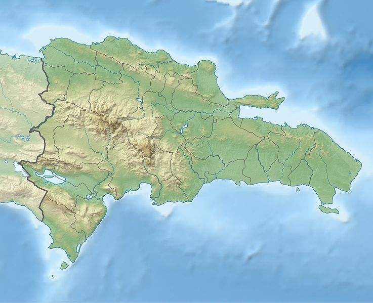
Deutsch: Physische Positionskarte Dominikanische Republik mit Provinzen, Quadratische Plattkarte, N-S-Streckung 105 %. Geographische Begrenzung der Karte:
English: Physical Location map Dominican Republic with Provinces, Equirectangular projection, N/S stretching 105 %. Geographic limits of the map:
|
||
| Date | |||
| Source | Own work, SRTM3, ETOPO1, VMAP0, http://www.one.gob.do, http://lib.utexas.edu/maps/dominican_republic.html | ||
| Author | Alexrk2 | ||
| Other versions |
|
||
| JPG development |
|


Licensing
I, the copyright holder of this work, hereby publish it under the following license:
This file is licensed under the Creative Commons Attribution-Share Alike 3.0 Unported license.
- You are free:
- to share – to copy, distribute and transmit the work
- to remix – to adapt the work
- Under the following conditions:
- attribution – You must give appropriate credit, provide a link to the license, and indicate if changes were made. You may do so in any reasonable manner, but not in any way that suggests the licensor endorses you or your use.
- share alike – If you remix, transform, or build upon the material, you must distribute your contributions under the same or compatible license as the original.
File history
Click on a date/time to view the file as it appeared at that time.
| Date/Time | Thumbnail | Dimensions | User | Comment | |
|---|---|---|---|---|---|
| current | 17:36, 8 February 2010 | | 1,338 × 1,088 (403 KB) | Alexrk2 | == Summary == {{Information |Description= {{de|Physische Positionskarte Dominikanische Republik mit Provinzen, Quadratische Plattkarte, N-S-Streckung 105 %. Geographische Begrenzung der Karte:}} {{en|Physical Location map |
File usage
More than 100 pages use this file. The following list shows the first 100 pages that use this file only. A full list is available.
- Agua Santa del Yuna
- Arenoso
- Arroyo Barril Airport
- Azua, Dominican Republic
- Baitoa
- Bajos de Haina
- Baní
- Barahona, Dominican Republic
- Bayaguana
- Bisonó
- Boca Chica
- Boca de Yuma
- Bohechío
- Bonao
- Bánica
- Cabrera, María Trinidad Sánchez
- Cambita Garabitos
- Cana Chapetón
- Castañuelas
- Castillo, Dominican Republic
- Cayetano Germosén
- Cibao International Airport
- Comendador, Dominican Republic
- Constanza, Dominican Republic
- Constanza Airport
- Consuelo, Dominican Republic
- Cotuí
- Dajabón
- Dominican Republic
- Duvergé
- El Pino, Dominican Republic
- El Portillo Airport
- El Seibo, Dominican Republic
- Enriquillo, Barahona
- Esperanza, Dominican Republic
- Estebanía
- Geography of the Dominican Republic
- Gregorio Luperón International Airport
- Guananico
- Gurabo, Dominican Republic
- Hato Mayor del Rey
- Jarabacoa
- Jimaní
- La Isabela International Airport
- La Romana, Dominican Republic
- La Romana International Airport
- Laguna Salada
- Lake Enriquillo
- Las Américas International Airport
- Licey al Medio
- Loma de Cabrera
- Los Cacaos
- Monción
- Monte Cristi, Dominican Republic
- Monte Plata
- Nagua
- Neiba
- Nizao
- Nizao River
- Orlando Martínez Howley
- Osvaldo Virgil Airport
- Paraíso, Barahona
- Pedro Brand
- Pedro Santana, Dominican Republic
- Peralta, Azua
- Pico Duarte
- Piedra Blanca
- Pimentel, Dominican Republic
- Polo, Dominican Republic
- Puerto Plata, Dominican Republic
- Quisqueya, Dominican Republic
- Ramón Santana
- Rivière Soliette
- Sabana Grande de Palenque
- Sabaneta, Dominican Republic
- Salcedo, Dominican Republic
- Samaná (town)
- Samaná El Catey International Airport
- San Antonio de Guerra
- San Cristóbal, Dominican Republic
- San Francisco de Macorís
- San Gregorio de Nigua
- San José de Ocoa
- San José de las Matas
- San José de los Llanos
- San Juan de la Maguana
- San Rafael del Yuma
- Santiago de los Caballeros
- Santo Domingo
- Santo Domingo Este
- Santo Domingo Norte
- Santo Domingo Oeste
- Tamboril, Dominican Republic
- Vicente Noble
- Villa Altagracia
- Villa Elisa, Dominican Republic
- Villa Hermosa
- Villa Los Almácigos
- Villa Riva
- Yaguate
View more links to this file.
Global file usage
The following other wikis use this file:
- Usage on af.wikipedia.org
- Usage on ar.wikipedia.org
- Usage on ast.wikipedia.org
- Usage on az.wikipedia.org
- Usage on ba.wikipedia.org
- Usage on be.wikipedia.org
- Usage on bg.wikipedia.org
- Usage on bn.wikipedia.org
- Usage on bs.wikipedia.org
- Usage on ca.wikipedia.org
- Usage on ceb.wikipedia.org
- Usage on ce.wikipedia.org
- Usage on ckb.wikipedia.org
- Usage on cs.wikipedia.org
- Usage on da.wikipedia.org
- Usage on de.wikipedia.org
View more global usage of this file.