
File:Edinburgh tramway map.svg

Size of this PNG preview of this SVG file: 800 × 259 pixels. Other resolutions: 320 × 104 pixels | 640 × 207 pixels | 1,024 × 331 pixels | 1,280 × 414 pixels | 2,560 × 828 pixels | 850 × 275 pixels.
Original file (SVG file, nominally 850 × 275 pixels, file size: 202 KB)
| This is a file from the Wikimedia Commons. Information from its description page there is shown below. Commons is a freely licensed media file repository. You can help. |
Summary
| Description |
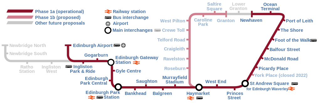
English: Map of the Edinburgh Trams system, showing the as built line (opened May 2014) alongside the various proposed lines that were ultimately abandoned or postponed indefinitely. |
| Date | |
| Source | Own work |
| Author | DavidArthur |
Licensing
I, the copyright holder of this work, hereby publish it under the following licenses:

|
Permission is granted to copy, distribute and/or modify this document under the terms of the GNU Free Documentation License, Version 1.2 or any later version published by the Free Software Foundation; with no Invariant Sections, no Front-Cover Texts, and no Back-Cover Texts. A copy of the license is included in the section entitled GNU Free Documentation License. |
This file is licensed under the Creative Commons Attribution-Share Alike 4.0 International, 3.0 Unported, 2.5 Generic, 2.0 Generic and 1.0 Generic license.
- You are free:
- to share – to copy, distribute and transmit the work
- to remix – to adapt the work
- Under the following conditions:
- attribution – You must give appropriate credit, provide a link to the license, and indicate if changes were made. You may do so in any reasonable manner, but not in any way that suggests the licensor endorses you or your use.
- share alike – If you remix, transform, or build upon the material, you must distribute your contributions under the same or compatible license as the original.
You may select the license of your choice.
File history
Click on a date/time to view the file as it appeared at that time.
| Date/Time | Thumbnail | Dimensions | User | Comment | |
|---|---|---|---|---|---|
| current | 14:58, 17 June 2023 | 850 × 275 (202 KB) | Cnbrb | fix text embedding | |
| 14:30, 17 June 2023 | 850 × 275 (159 KB) | Cnbrb | newhaven branch now operational; typographical and symbolic improvements | ||
| 14:06, 11 May 2020 | 850 × 275 (88 KB) | Angryskies | '''West End - Princes Street''' tram stop renamed to '''West End''' | ||
| 20:17, 21 April 2020 | 850 × 275 (90 KB) | Angryskies | Updated details of line to Newhaven under construction. | ||
| 13:06, 25 September 2017 | 850 × 275 (91 KB) | Sladen | Inclusion of Edinburgh Gateway Station. | ||
| 18:08, 28 September 2013 | 850 × 275 (88 KB) | Sladen | Rename "Shandwick Place" to "West End – Princes Street" per {{cite news|url=http://www.edinburghnews.scotsman.com/news/transport/trams-shandwick-place-stop-renamed-princes-street-1-3106746|title=Trams: Shandwick Place stop renamed Princes Street|firs... | ||
| 13:13, 9 February 2013 | 850 × 275 (88 KB) | Sladen | Split Phase 1a (as built) from Phase 1a (not built) and show as dotted line. Reduce prominence of planned stations to focus on as-built section. Tweak key to include difference, and add "Airport" + pictogram for completeness. + remove errornous extr... | ||
| 13:12, 9 February 2013 | 850 × 275 (88 KB) | Sladen | Split Phase 1a (as built) from Phase 1a (not built) and show as dotted line. Reduce prominence of planned stations to focus on as-built section. Tweak key to include difference, and add "Airport" + pictogram for completeness. | ||
proposed Edinburgh tramway.}} |Source=self-made |Date=17 November 2007 |Author= DavidArthur |Permission= |
File usage
The following pages on the English Wikipedia use this file (pages on other projects are not listed):
Global file usage
The following other wikis use this file:
- Usage on cs.wikipedia.org
- Usage on cy.wikipedia.org
- Usage on de.wikipedia.org
- Usage on eo.wikipedia.org
- Usage on es.wikipedia.org
- Usage on fi.wikipedia.org
- Usage on fr.wikipedia.org
- Usage on he.wikipedia.org
- Usage on he.wikivoyage.org
- Usage on ja.wikipedia.org
- Usage on www.wikidata.org
- Usage on zh.wikipedia.org