
File:ElectoralCollege1980.svg

Size of this PNG preview of this SVG file: 800 × 465 pixels. Other resolutions: 320 × 186 pixels | 640 × 372 pixels | 1,024 × 595 pixels | 1,280 × 744 pixels | 2,560 × 1,488 pixels | 1,020 × 593 pixels.
Original file (SVG file, nominally 1,020 × 593 pixels, file size: 28 KB)
| This is a file from the Wikimedia Commons. Information from its description page there is shown below. Commons is a freely licensed media file repository. You can help. |
Summary
| Description |
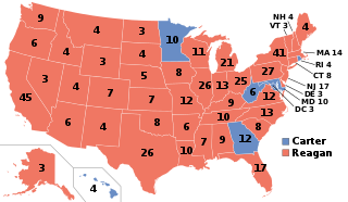
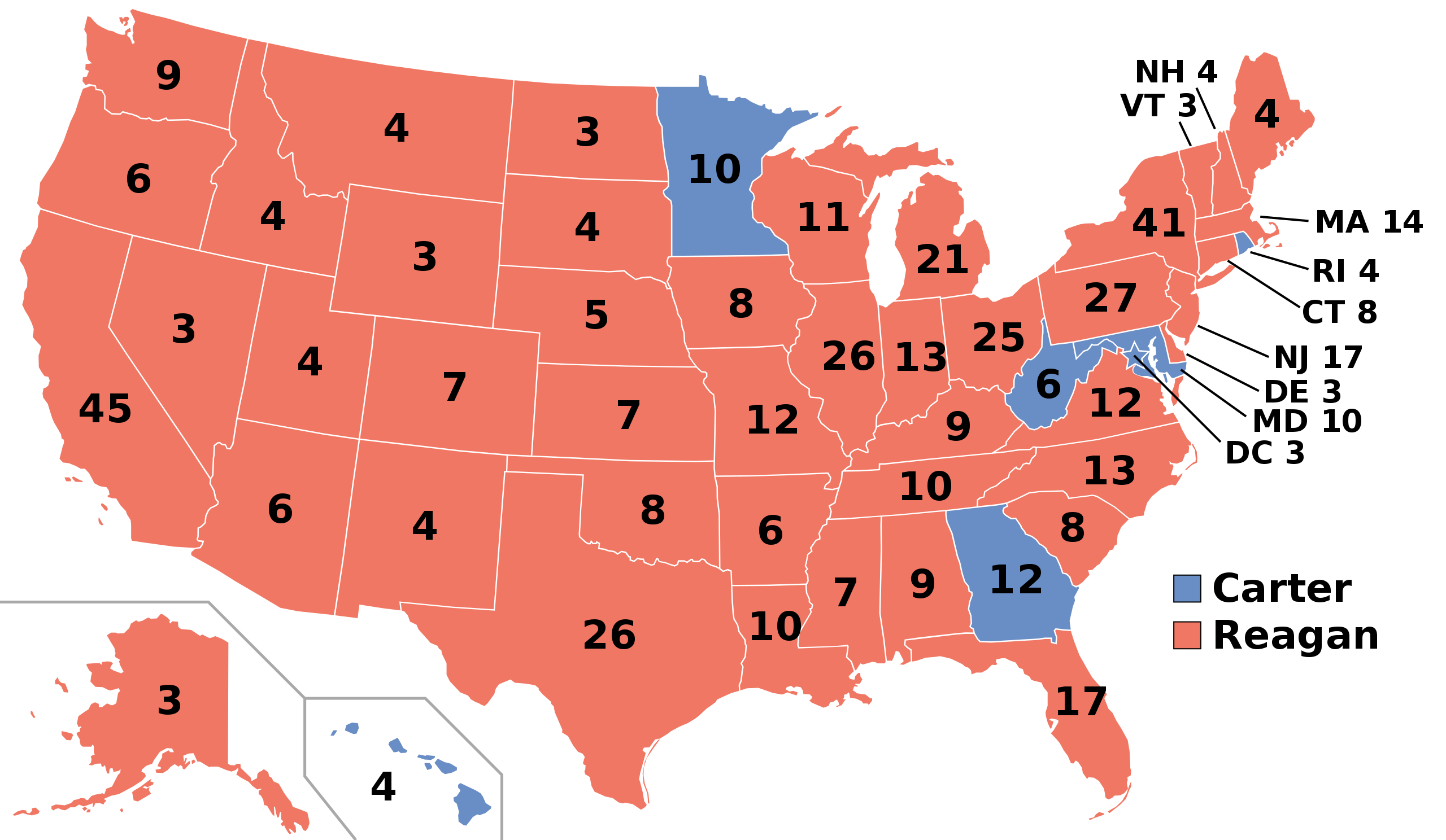
English: Electoral College results map for the 1980 United States presidential election between Ronald Reagan and Jimmy Carter based on: https://www.archives.gov/electoral-college/1980 |
| Date | |
| Source | Own work |
| Author | SteveSims~commonswiki |
| U.S. presidential election maps (SVG) |
| See also: National Atlas maps (png) |
|
1789 · 1792 · 1796 · 1800 · 1804 · 1808 · 1812 · 1816 · 1820 · 1824 · 1828 · 1832 · 1836 · 1840 · 1844 · 1848 · 1852 · 1856 · 1860 · 1864 · 1868 · 1872 · 1876 · 1880 · 1884 · 1888 · 1892 · 1896 · 1900 · 1904 · 1908 · 1912 · 1916 · 1920 · 1924 · 1928 · 1932 · 1936 · 1940 · 1944 · 1948 · 1952 · 1956 · 1960 · 1964 · 1968 · 1972 · 1976 · 1980 · 1984 · 1988 · 1992 · 1996 · 2000 · 2004 · 2008 · 2012 · 2016 · 2020 · 2024 |
Licensing
| I, the copyright holder of this work, release this work into the public domain. This applies worldwide. In some countries this may not be legally possible; if so: I grant anyone the right to use this work for any purpose, without any conditions, unless such conditions are required by law. |
File history
Click on a date/time to view the file as it appeared at that time.
| Date/Time | Thumbnail | Dimensions | User | Comment | |
|---|---|---|---|---|---|
| current | 12:56, 28 December 2018 | | 1,020 × 593 (28 KB) | Newfraferz87 | Optimize |
| 11:43, 6 February 2017 |  | 1,020 × 593 (34 KB) | Newfraferz87 | Clearer state borders | |
| 23:31, 13 November 2016 |  | 1,020 × 593 (44 KB) | Wow | Space between MA and 14 | |
| 21:39, 13 November 2016 |  | 1,020 × 593 (43 KB) | Wow | One last change | |
| 21:38, 13 November 2016 |  | 1,020 × 593 (43 KB) | Wow | Removed line and changed DC | |
| 02:15, 12 November 2016 |  | 1,020 × 593 (119 KB) | Tony Patt | Reverted to version as of 02:06, 23 June 2008 (UTC) : disproportionate when used with image map | |
| 11:30, 18 November 2011 |  | 1,004 × 588 (91 KB) | Citypeek | removal line | |
| 02:06, 23 June 2008 |  | 1,020 × 593 (119 KB) | SteveSims~commonswiki | Washington fixed | |
| 21:52, 21 June 2008 |  | 1,020 × 593 (119 KB) | SteveSims~commonswiki | Correct electoral college numbers. | |
| 22:54, 14 June 2008 |  | 1,020 × 593 (119 KB) | SteveSims~commonswiki | == Summary == I created this image based on this map from the WikiMedia Commons: http://commons.wikimedia.org/wiki/Image:Blank_US_Map.svg It is in the public domain. == Licensing == {{PD-self}} |
File usage
The following pages on the English Wikipedia use this file (pages on other projects are not listed):
- 1980 United States elections
- 1980 United States presidential election
- 1980 United States presidential election in Alabama
- 1980 United States presidential election in Alaska
- 1980 United States presidential election in Arizona
- 1980 United States presidential election in Arkansas
- 1980 United States presidential election in California
- 1980 United States presidential election in Colorado
- 1980 United States presidential election in Connecticut
- 1980 United States presidential election in Delaware
- 1980 United States presidential election in Florida
- 1980 United States presidential election in Georgia
- 1980 United States presidential election in Hawaii
- 1980 United States presidential election in Idaho
- 1980 United States presidential election in Illinois
- 1980 United States presidential election in Indiana
- 1980 United States presidential election in Iowa
- 1980 United States presidential election in Kansas
- 1980 United States presidential election in Kentucky
- 1980 United States presidential election in Louisiana
- 1980 United States presidential election in Maine
- 1980 United States presidential election in Maryland
- 1980 United States presidential election in Massachusetts
- 1980 United States presidential election in Michigan
- 1980 United States presidential election in Minnesota
- 1980 United States presidential election in Mississippi
- 1980 United States presidential election in Missouri
- 1980 United States presidential election in Montana
- 1980 United States presidential election in Nebraska
- 1980 United States presidential election in Nevada
- 1980 United States presidential election in New Hampshire
- 1980 United States presidential election in New Jersey
- 1980 United States presidential election in New Mexico
- 1980 United States presidential election in New York
- 1980 United States presidential election in North Carolina
- 1980 United States presidential election in North Dakota
- 1980 United States presidential election in Ohio
- 1980 United States presidential election in Oklahoma
- 1980 United States presidential election in Oregon
- 1980 United States presidential election in Pennsylvania
- 1980 United States presidential election in Rhode Island
- 1980 United States presidential election in South Carolina
- 1980 United States presidential election in South Dakota
- 1980 United States presidential election in Tennessee
- 1980 United States presidential election in Texas
- 1980 United States presidential election in Utah
- 1980 United States presidential election in Vermont
- 1980 United States presidential election in Virginia
- 1980 United States presidential election in Washington (state)
- 1980 United States presidential election in West Virginia
- 1980 United States presidential election in Wisconsin
- 1980 United States presidential election in Wyoming
- 1980 United States presidential election in the District of Columbia
- Electoral history of George H. W. Bush
- Electoral history of Ronald Reagan
- Electoral vote changes between United States presidential elections
- George H. W. Bush
- George H. W. Bush 1980 presidential campaign
- Jimmy Carter
- List of United States presidential election results by state
- Presidency of Jimmy Carter
- Presidency of Ronald Reagan
- Ronald Reagan
- Ronald Reagan 1980 presidential campaign
- United States presidential election
- User:2002crash1/sandbox
- User:DukeOfDelTaco/U.S. Presidential Elections
- User:Hogne/us electioons
- User:Mx374/sandbox
- User:Pasta 4431/sandbox
- User:PerfectAccount18/sandbox
- User:PresidentZinn/sandbox
- User:Sciscisciortino/sandbox
- User:Theothresh/sandbox
- User:Yqfan00
- Template:1980 United States presidential election imagemap
- Template:State results of the 1980 U.S. presidential election
- Portal:Conservatism/Selected anniversary
- Portal:Conservatism/Selected anniversary/November
Global file usage
The following other wikis use this file:
- Usage on ast.wikipedia.org
- Usage on az.wikipedia.org
- Usage on bg.wikipedia.org
- Usage on ca.wikipedia.org
- Usage on da.wikipedia.org
- Usage on de.wikipedia.org
- Usage on el.wikipedia.org
- Usage on es.wikipedia.org
- Usage on fa.wikipedia.org
- Usage on fi.wikipedia.org
- Usage on fr.wikipedia.org
- Liste des résultats des élections présidentielles américaines
- Liste des candidats démocrates à la présidence des États-Unis
- Élection présidentielle américaine de 1980
- Présidence de Jimmy Carter
- Présidence de Ronald Reagan
- Modèle:Palette Élection présidentielle américaine de 1980
- Élection présidentielle américaine de 1980 en Alabama
- Élection présidentielle américaine de 1980 en Alaska
- Élection présidentielle américaine de 1980 dans le Mississippi
- Élection présidentielle américaine de 1980 en Virginie-Occidentale
- Élection présidentielle américaine de 1980 au Kentucky
- Élection présidentielle américaine de 1980 dans l'État de New York
- Élection présidentielle américaine de 1980 en Géorgie
- Élection présidentielle américaine de 1980 en Louisiane
- Élection présidentielle américaine de 1980 en Caroline du Sud
- Usage on he.wikipedia.org
- Usage on hu.wikipedia.org
- Usage on is.wikipedia.org
- Usage on it.wikipedia.org
- Usage on ja.wikipedia.org
- Usage on ko.wikipedia.org
- Usage on lt.wikipedia.org
- Usage on lv.wikipedia.org
- Usage on no.wikipedia.org
- Usage on pl.wikipedia.org
- Usage on pt.wikipedia.org
- Usage on ro.wikipedia.org
- Usage on ru.wikipedia.org
- Usage on simple.wikipedia.org
View more global usage of this file.