
File:Embassy of Chad (Washington, D.C.).JPG

Size of this preview: 692 × 600 pixels. Other resolutions: 277 × 240 pixels | 554 × 480 pixels | 887 × 768 pixels | 1,182 × 1,024 pixels | 1,976 × 1,712 pixels.
Original file (1,976 × 1,712 pixels, file size: 1.75 MB, MIME type: image/jpeg)
| This is a file from the Wikimedia Commons. Information from its description page there is shown below. Commons is a freely licensed media file repository. You can help. |
.JPG)
| Description |
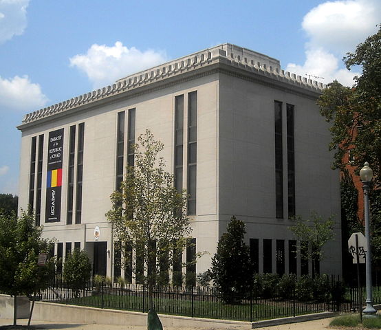
English: The Embassy of Chad located at 2401 Massachusetts Avenue NW in the Sheridan-Kalorama neighborhood of Washington, D.C. From 1957 until 2002, the building served as the Embassy of Malaysia (Embassy of the Federation of Malaya, 1957–1963). In 2008, the building was purchased by the government of Chad. After a four-month renovation in 2009, Embassy of Chad employees moved from their 2002 R Street NW building into the new facility.
Français : Ambassade de Tchad à Washington
Deutsch: Botschaft der Republik des Tschads in Washington D.C., USA |
||
| Date | |||
| Source | Own work | ||
| Author |
AgnosticPreachersKid |
||
| Permission (Reusing this file) |
I, the copyright holder of this work, hereby publish it under the following license: This file is licensed under the Creative Commons Attribution-Share Alike 3.0 Unported license.
|
| Camera location | | View this and other nearby images on: OpenStreetMap |
|---|
.JPG¶ms=038.914096_N_-077.052694_E_globe:Earth_type:camera__&language=en)
File history
Click on a date/time to view the file as it appeared at that time.
| Date/Time | Thumbnail | Dimensions | User | Comment | |
|---|---|---|---|---|---|
| current | Sheridan-Kalorama nei |
File usage
The following pages on the English Wikipedia use this file (pages on other projects are not listed):
Global file usage
The following other wikis use this file:
- Usage on ar.wikipedia.org
- Usage on arz.wikipedia.org
- Usage on bs.wikipedia.org
- Usage on ca.wikipedia.org
- Usage on de.wikipedia.org
- Usage on es.wikipedia.org
- Usage on fa.wikipedia.org
- Usage on fr.wikipedia.org
- Usage on he.wikipedia.org
- Usage on hr.wikipedia.org
- Usage on id.wikipedia.org
- Usage on it.wikipedia.org
- Usage on kk.wikipedia.org
- Usage on ko.wikipedia.org
- Usage on mt.wikipedia.org
- Usage on pl.wikipedia.org
- Usage on pt.wikipedia.org
- Usage on ru.wikipedia.org
- Usage on si.wikipedia.org
- Usage on tum.wikipedia.org
- Usage on vi.wikipedia.org
- Usage on www.wikidata.org
- Usage on zh.wikipedia.org
.JPG)