
File:Empire Chinois, Japon (1832).jpg

Size of this preview: 800 × 594 pixels. Other resolutions: 320 × 238 pixels | 640 × 475 pixels | 1,024 × 760 pixels | 1,280 × 950 pixels | 2,560 × 1,901 pixels | 9,174 × 6,811 pixels.
Original file (9,174 × 6,811 pixels, file size: 15.68 MB, MIME type: image/jpeg)
| This is a file from the Wikimedia Commons. Information from its description page there is shown below. Commons is a freely licensed media file repository. You can help. |
.jpg)
Summary
| Warning | The original file is very high-resolution. It might not load properly or could cause your browser to freeze when opened at full size. |
|---|
| Description |
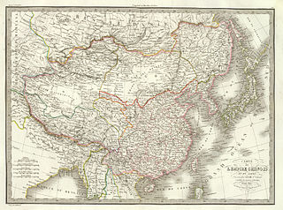
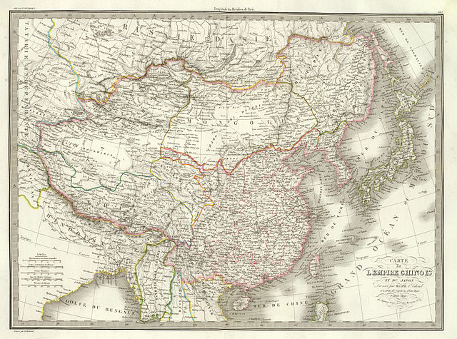
English: 1832 French map of China and Japan by Lapie, Alexandre Emile; Lapie, M. (Pierre); published by Eymery Fruger et Cie in Paris. |
|||||||||||||||||||||||||||||||||||
| Date | ||||||||||||||||||||||||||||||||||||
| Source | Carte de l'Empire Chinois et du Japon. Dressee par M. Lapie, Lt. Colonel et Lapie fils, Capitaine d'Etat Major. Paris, 1832. Chez Eymery Fruger et Cie., Rue Mazarine No. 30. Gravee par Lallemand. | |||||||||||||||||||||||||||||||||||
| Author |
|
|||||||||||||||||||||||||||||||||||
Licensing
This media file is in the public domain in the United States. This applies to U.S. works where the copyright has expired, often because its first publication occurred prior to January 1, 1929, and if not then due to lack of notice or renewal. See this page for further explanation.
|
 | |
 |
This image might not be in the public domain outside of the United States; this especially applies in the countries and areas that do not apply the rule of the shorter term for US works, such as Canada, Mainland China (not Hong Kong or Macao), Germany, Mexico, and Switzerland. The creator and year of publication are essential information and must be provided. See Wikipedia:Public domain and Wikipedia:Copyrights for more details.
|
File history
Click on a date/time to view the file as it appeared at that time.
| Date/Time | Thumbnail | Dimensions | User | Comment | |
|---|---|---|---|---|---|
| current | 09:42, 23 September 2011 | | 9,174 × 6,811 (15.68 MB) | Benlisquare | accidentally uploaded the wrong file earlier. this is the correct file. |
| 08:52, 23 September 2011 |  | 8,317 × 6,061 (12.79 MB) | Benlisquare | {{Information |Description ={{en|1=1832 French map of China and Japan by Lapie, Alexandre Emile; Lapie, M. (Pierre); published by Eymery Fruger et Cie in Paris.}} |Source =Carte de l'Empire Chinois et du Japon. Dressee par M. Lapie, Lt. Colonel |
File usage
The following pages on the English Wikipedia use this file (pages on other projects are not listed):
Global file usage
The following other wikis use this file:
- Usage on bcl.wikipedia.org
- Usage on ca.wikipedia.org
- Usage on es.wikipedia.org
- Usage on fr.wikipedia.org
- Usage on hy.wikipedia.org
- Usage on id.wikipedia.org
- Usage on ja.wikipedia.org
- Usage on mn.wikipedia.org
- Usage on pt.wikipedia.org
- Usage on ru.wikipedia.org
- Usage on www.wikidata.org
- Usage on zh.wikipedia.org
.jpg)