
File:EnglandCentralBedfordshire.png
No higher resolution available.
EnglandCentralBedfordshire.png (200 × 247 pixels, file size: 25 KB, MIME type: image/png)
| This is a file from the Wikimedia Commons. Information from its description page there is shown below. Commons is a freely licensed media file repository. You can help. |
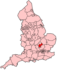
| Description | Map showing location of Central Bedfordshire Unitary Authority (effective 1st April 2009) in England. |
| Date | |
| Source | Own work, derived from File:BlankMap-EnglandSubdivisions2009.png. |
| Author | Keith Edkins |
Licensing
| This file is licensed under the Creative Commons Attribution-Share Alike 3.0 Unported license. Subject to disclaimers. | ||
| ||
| This licensing tag was added to this file as part of the GFDL licensing update. |

|
Permission is granted to copy, distribute and/or modify this document under the terms of the GNU Free Documentation License, Version 1.2 or any later version published by the Free Software Foundation; with no Invariant Sections, no Front-Cover Texts, and no Back-Cover Texts. A copy of the license is included in the section entitled GNU Free Documentation License. Subject to disclaimers. |
File history
Click on a date/time to view the file as it appeared at that time.
| Date/Time | Thumbnail | Dimensions | User | Comment | |
|---|---|---|---|---|---|
| current | 00:05, 13 March 2009 | | 200 × 247 (25 KB) | Keith Edkins | Minutely more red |
| 09:41, 12 March 2009 |  | 200 × 247 (25 KB) | Keith Edkins | {{Information |Description=Map showing location of Central Bedfordshire Unitary Authority (effective 1st April 2009) in England. |Source=Own work, derived from File:BlankMap-EnglandSubdivisions2009.png. |Date=12 March 2009 |Author=[[User:Keith Edkins |
File usage
No pages on the English Wikipedia use this file (pages on other projects are not listed).
Global file usage
The following other wikis use this file:
- Usage on uk.wikipedia.org
- Usage on www.wikidata.org