
File:Ephesos overall plan.svg

Size of this PNG preview of this SVG file: 750 × 358 pixels. Other resolutions: 320 × 153 pixels | 640 × 305 pixels | 1,024 × 489 pixels | 1,280 × 611 pixels | 2,560 × 1,222 pixels.
Original file (SVG file, nominally 750 × 358 pixels, file size: 614 KB)
| This is a file from the Wikimedia Commons. Information from its description page there is shown below. Commons is a freely licensed media file repository. You can help. |
Summary
| Description |
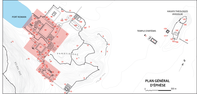
Historical topography of Ephesos. Geographical data from P. Scherrer (ed.), Ephesos, The New Guide, Selçuk, 2000. 1. Artemision; 2. “Tribune” near the Artemision; 3. Port of Koressos; 4. Rock Sanctuary of the Great Mother - Cybele; 5. Byzantine aqueduct; 6. Archaic rampart (Coressos); 7. Stoa of Damianus; 8. Necropolis of the Seven Sleepers; 9. Armenian Shrine; 10. Gate of Magnesia; 11. Hellenistic rampart; 12. Old gymnasium; 13. Basilica east of the gymnasium; 14. “Tomb of Saint Luke”; 15. Fountain; 16. Civic Agora Baths; 17. Fountain; 18. “Civic Agora”; 19. South colonnade of the “Civic Agora” and Doric door; 20. Temple of the Civic Agora; 21. Stoa basilica; 22. Odeon / Bouleuterion; 23. Temenos at the double monument; 24. Prytaneum; 25. Banquet house near the Prytanée; 26. Cathodos of the Prytanée with base; 27. Chalcidicium; 28. Monument of Pollio and Fountain of Domitian; 29. Hydrecdocheion of Laecanius Bassus; 30. Temple of Domitian; 31. Monument niche; 32. Monument of Memmius; 33. Hydrion; 34. Round monument; 35. Gate of Hercules; 36. Rue des Courètes (Embolos); 37. Gate of Trajan; 38. Nymphaeum of Trajan; 39. Thermal baths street; 40. Temple of Hadrian (Embolos); 41. Bath of Varius / Baths of Scholasticia; 42. Rue de l'Académie; 43. Latrine and “House of Pleasures”; 44. Stoa of the Alytarchs; 45. Hellenistic well; 46. Hexagon / nymphaeum; 47. Octagon; 48. Heroon of Androclos; 49. Hadrian's Gate; 50. Terraced Houses 1 (Hanghaus 1); 51. Terraced Houses 2 (Hanghaus 2); 52. Foundations of an altar; 53. Hellenistic peristyle house; 54. Door known as the “tube” (?); 55. Library of Celsus; 56. South Gate of the Agora; 57. Tomb of the rhetorician Dionysios; 58. Brick Vault (Embolos); 59. Circular Fountain Monument; 60. Marble Street; 61. Agora Tétragone (Market); 62. Hall of Nero; 63. West Gate of the Agora; 64. North Gate of the Agora; 65. West Street; 66. Gate to the Medusa; 67. Temple (Serapeion); 70. Royal monument (on the Bülbüldağ); 71. Cave of Saint Paul; 72. Theater square with fountain; 73. Eastern gate of the Arkadianè; 74. Western Hellenistic House; 75. Theatre; 76. Byzantine House (Panayırdağ); 77. Byzantine enclosure; 78. Theater Street (Plateia in Coressus); 79. Theater gymnasium; 80. Monument to apse; 81. Byzantine Palace; 82. Arkadiane; 83. Arkadianè and adjacent colonnade; 84. Monument to the four columns; 85. Church south of Arkadianè; 86. Exedra; 87. Port Intermediate Gate; 88. Port South Gate; 89. Port North Gate; 90. Port Market; 91. Atrium Thermarum; 92. Port Baths; 93. Port Gymnasium; 94. Xystoi / Halls of Verulanus; 95. Church of the Virgin Mary; 96. Baptistry of the Church of the Virgin; 97. Episkopeion of the Church of the Virgin; 98. Olympiaion; 99. Acropolis; 100. Macellum; 101. Byzantine well; 102. Late antique peristyle house; Hellenistic enclosure; 103. Cave temple; 104. Stadium; 105. Stadium Church; 106. Gymnasium of Vedius; 107. Gate of Coressos; 110. Route south from Porte de Magnesia; 115. Upper entrance to Ephesus; 116. Lower entrance to Ephesus; 151. Citadel of St. John/Ayasoluk; 152. Basilica of Saint John the Theologian; 153. Mycenaean tomb; 154. Classical tomb; 155. Prehistoric settlement area; 156. Byzantine aqueduct; 157. Gate of Persecutions; 170. İsa Bey Mosque; 171. Isa Bey Hamam (Hamam II); 173. Hamam III. |
| Date | |
| Source | Own work |
| Author | Marsyas |
| Other versions |
Submaps:
|


Licensing
I, the copyright holder of this work, hereby publish it under the following licenses:

|
Permission is granted to copy, distribute and/or modify this document under the terms of the GNU Free Documentation License, Version 1.2 or any later version published by the Free Software Foundation; with no Invariant Sections, no Front-Cover Texts, and no Back-Cover Texts. A copy of the license is included in the section entitled GNU Free Documentation License. |
This file is licensed under the Creative Commons Attribution 3.0 Unported license.
- You are free:
- to share – to copy, distribute and transmit the work
- to remix – to adapt the work
- Under the following conditions:
- attribution – You must give appropriate credit, provide a link to the license, and indicate if changes were made. You may do so in any reasonable manner, but not in any way that suggests the licensor endorses you or your use.
You may select the license of your choice.
File history
Click on a date/time to view the file as it appeared at that time.
| Date/Time | Thumbnail | Dimensions | User | Comment | |
|---|---|---|---|---|---|
| current | 17:14, 20 April 2008 | | 750 × 358 (614 KB) | Marsyas | {{Information |Description=Historical topography of Ephesos. Geographical data from P. Scherrer (ed.), ''Ephesos, The New Guide'', Selçuk, 2000. |Source=self-made |Date=2008.04.13 |Author= Marsyas |Permission= |other_versions= }} == [[C |
File usage
The following pages on the English Wikipedia use this file (pages on other projects are not listed):
Global file usage
The following other wikis use this file:
- Usage on de.wikipedia.org
- Usage on fi.wikipedia.org
- Usage on fr.wikipedia.org
- Usage on hi.wikipedia.org
- Usage on mk.wikipedia.org