
File:Flag-map of the world (1900).png

Size of this preview: 800 × 397 pixels. Other resolutions: 320 × 159 pixels | 640 × 318 pixels | 1,024 × 508 pixels | 1,280 × 635 pixels | 2,560 × 1,271 pixels | 4,500 × 2,234 pixels.
Original file (4,500 × 2,234 pixels, file size: 628 KB, MIME type: image/png)
| This is a file from the Wikimedia Commons. Information from its description page there is shown below. Commons is a freely licensed media file repository. You can help. |
.png)
Summary
| Description |
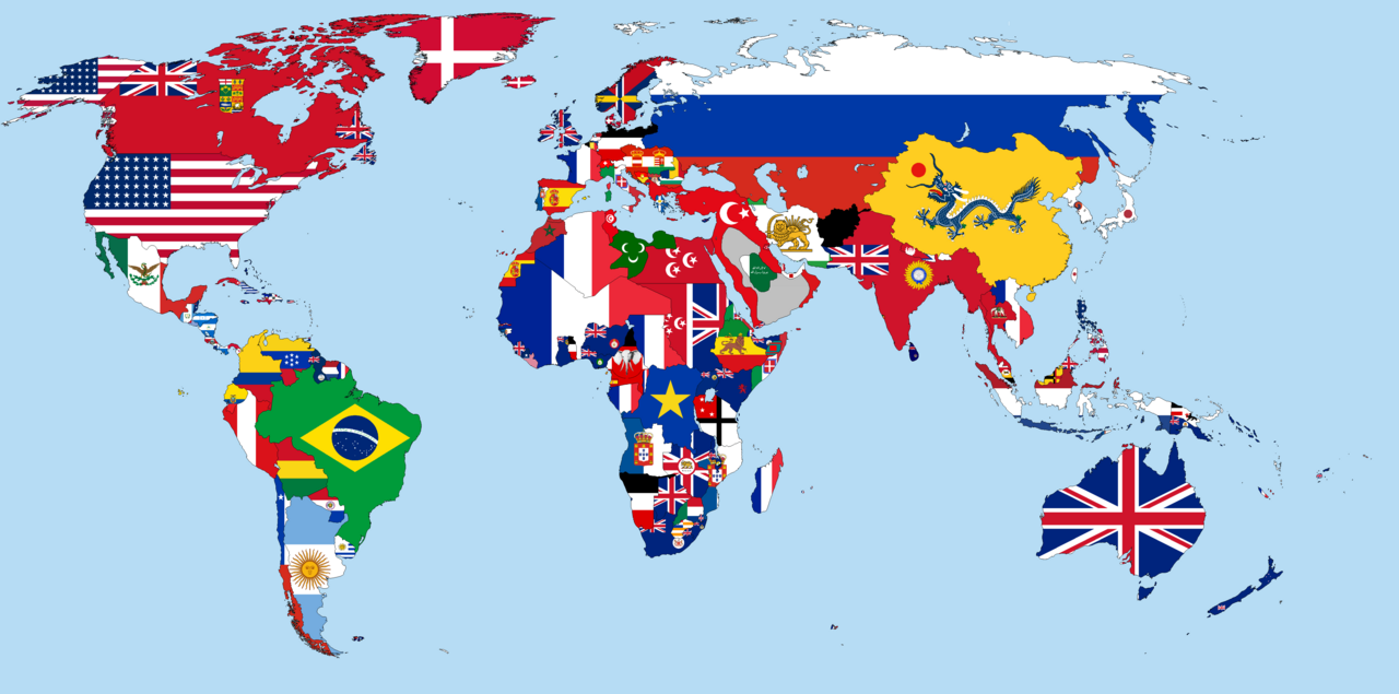
English: This is a world map in 1900, which shows flags of countries and colonies covering their territory. It is in Kavrayskiy VII projection.
|
|||||
| Date | ||||||
| Source | Own work | |||||
| Author | Alvin Lee | |||||
.png)
.png)
.png)
.png)
.png)
.png)
.png)
.png)
.png)
.png)
.png)
.png)
.png)
.png)
.png)
.png)
.png)
.png)
.png)
.png)
.png)
.png)
.png)
.png)
.png)
.png)
.png)
.png)
.png)
Licensing
I, the copyright holder of this work, hereby publish it under the following license:
This file is licensed under the Creative Commons Attribution-Share Alike 4.0 International license.
- You are free:
- to share – to copy, distribute and transmit the work
- to remix – to adapt the work
- Under the following conditions:
- attribution – You must give appropriate credit, provide a link to the license, and indicate if changes were made. You may do so in any reasonable manner, but not in any way that suggests the licensor endorses you or your use.
- share alike – If you remix, transform, or build upon the material, you must distribute your contributions under the same or compatible license as the original.
File history
Click on a date/time to view the file as it appeared at that time.
| Date/Time | Thumbnail | Dimensions | User | Comment | |
|---|---|---|---|---|---|
| current | 18:59, 28 February 2023 | | 4,500 × 2,234 (628 KB) | Marcomogollon | corrections |
| 18:41, 28 February 2023 |  | 4,500 × 2,234 (631 KB) | Marcomogollon | Ecuador has never had access to the Amazon River since its independence, this is a hoax without evidence. The region passed into Peruvian hands from the colony by means of a Royal Decree of 1802 | |
| 18:04, 19 November 2022 |  | 4,500 × 2,234 (639 KB) | NSassin | Changed the Alaskan flag to that of the United States, and added a border around the Dervish State. | |
| 19:09, 15 March 2022 |  | 4,500 × 2,234 (636 KB) | Randomastwritter | added dervish | |
| 15:30, 22 August 2018 |  | 4,500 × 2,234 (635 KB) | Illslidia | Tunisia was a French colony in 1900. | |
| 00:05, 8 December 2016 |  | 4,500 × 2,234 (635 KB) | NSassin | Fixed Nigeria. North and South Nigera weren't united until 1914. | |
| 04:16, 4 December 2016 |  | 4,500 × 2,234 (634 KB) | NSassin | Smoothed out borders and fixed various flags. | |
| 15:53, 25 March 2015 |  | 4,500 × 2,234 (649 KB) | Alvin Lee | sudan | |
| 15:35, 25 March 2015 |  | 4,500 × 2,234 (649 KB) | Alvin Lee | User created page with UploadWizard |
File usage
The following pages on the English Wikipedia use this file (pages on other projects are not listed):
Global file usage
The following other wikis use this file:
- Usage on ba.wikipedia.org
- Usage on bg.wikipedia.org
- Usage on en.wikibooks.org
- Usage on fa.wikipedia.org
- Usage on ta.wiktionary.org
.png)