
File:Formula1 Circuit Catalunya.svg

Size of this PNG preview of this SVG file: 800 × 294 pixels. Other resolutions: 320 × 118 pixels | 640 × 235 pixels | 1,024 × 376 pixels | 1,280 × 471 pixels | 2,560 × 941 pixels | 1,409 × 518 pixels.
Original file (SVG file, nominally 1,409 × 518 pixels, file size: 59 KB)
| This is a file from the Wikimedia Commons. Information from its description page there is shown below. Commons is a freely licensed media file repository. You can help. |
Summary
| Description |
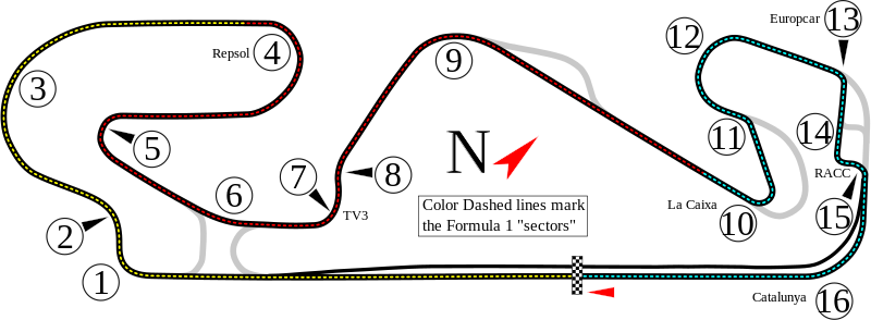
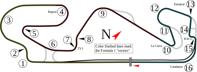
English: Track map for Circuit de Catalunya. The colored dash lines are the Formula 1 sectors. |
| Date | |
| Source | Own work |
| Author | Will Pittenger |
| Other versions |
|


| Camera location | | View this and other nearby images on: OpenStreetMap |
|---|
This W3C-unspecified vector image was created with Inkscape .
Licensing
I, the copyright holder of this work, hereby publish it under the following license:
This file is licensed under the Creative Commons Attribution-Share Alike 3.0 Unported license.
- You are free:
- to share – to copy, distribute and transmit the work
- to remix – to adapt the work
- Under the following conditions:
- attribution – You must give appropriate credit, provide a link to the license, and indicate if changes were made. You may do so in any reasonable manner, but not in any way that suggests the licensor endorses you or your use.
- share alike – If you remix, transform, or build upon the material, you must distribute your contributions under the same or compatible license as the original.
File history
Click on a date/time to view the file as it appeared at that time.
| Date/Time | Thumbnail | Dimensions | User | Comment | |
|---|---|---|---|---|---|
| current | 01:11, 18 May 2017 | 1,409 × 518 (59 KB) | Sentoan | Actualizando nombres y trazado (2017) | |
| 19:25, 3 June 2016 | 1,409 × 518 (68 KB) | Gpmat | Repoil→Repsol | ||
| 17:31, 12 May 2013 | 1,409 × 518 (68 KB) | Cs-wolves | Reverted to version as of 12:22, 5 August 2008; DRS notation unnecessary on a general map, used for various series... | ||
| 00:14, 25 April 2013 | 1,530 × 583 (117 KB) | HorsePunchKid | Added DRS points and updated corner names | ||
w:Circuit de Catalunya. The colored dash lines are the Formula 1 sectors.}} |Source=Own work by uploader |Author=Will Pittenger |Date=8-5-2008 |Permission= |other_versions= |
File usage
The following pages on the English Wikipedia use this file (pages on other projects are not listed):
- 2007 Catalunya GP2 Series round
- 2007 Spanish Grand Prix
- 2008 1000 km of Catalunya
- 2008 Catalunya GP2 Series round
- 2008 Spanish Grand Prix
- 2009 1000 km of Catalunya
- 2009 Catalunya Formula Two round
- 2009 Catalunya GP2 Series round
- 2009 Spanish Grand Prix
- 2010 Catalunya GP2 Series round
- 2010 Catalunya GP3 Series round
- 2010 Spanish Grand Prix
- 2011 Catalunya GP2 Series round
- 2011 Catalunya GP3 Series round
- 2011 Spanish Grand Prix
- 2012 Catalunya GP2 Series round
- 2012 Catalunya GP3 Series round
- 2012 Spanish Grand Prix
- 2013 Catalunya GP2 Series round
- 2013 Catalunya GP3 Series round
- 2013 Spanish Grand Prix
- 2014 Catalunya GP2 Series round
- 2014 Catalunya GP3 Series round
- 2014 Spanish Grand Prix
- 2015 Catalunya GP2 Series round
- 2015 Catalunya GP3 Series round
- 2015 Spanish Grand Prix
- 2016 Catalan motorcycle Grand Prix
- 2016 Catalunya GP2 Series round
- 2016 Catalunya GP3 Series round
- 2016 Spanish Grand Prix
- 2017 Barcelona Formula 2 round
- 2017 Barcelona GP3 Series round
- 2017 Catalan motorcycle Grand Prix
- 2017 Spanish Grand Prix
- 2018 Barcelona Formula 2 round
- 2018 Barcelona GP3 Series round
- 2018 Moto2 World Championship
- 2018 Moto3 World Championship
- 2018 MotoGP World Championship
- 2018 Spanish Grand Prix
- 2019 Barcelona Formula 2 round
- 2019 Barcelona Formula 3 round
- 2019 Spanish Grand Prix
- 2020 Barcelona Formula 2 round
- 2020 Barcelona Formula 3 round
- 2020 Formula One pre-season testing
- 2020 Spanish Grand Prix
- Catalunya GP2 round
- Circuit de Barcelona-Catalunya
- Luis Salom
- User:Aquadeias/F1 2009 Gallery
- User:Aquadeias/S.Vettel
- User:KembanganGreen
- User:Troggy3112/F12010/2010/RaceResults
- Portal:Formula One
- Portal:Spain
Global file usage
The following other wikis use this file:
- Usage on af.wikipedia.org
- Usage on ar.wikipedia.org
- حلبة دي كاتلونيا
- جائزة إسبانيا الكبرى 2010
- جائزة إسبانيا الكبرى 2009
- جائزة كتالونيا الكبرى للدراجات النارية 1997
- جائزة إسبانيا الكبرى 2015
- جائزة إسبانيا الكبرى 2014
- جائزة إسبانيا الكبرى 2013
- جائزة إسبانيا الكبرى
- جائزة إسبانيا الكبرى 2008
- جائزة إسبانيا الكبرى 2007
- جائزة إسبانيا الكبرى 2017
- جائزة إسبانيا الكبرى 2016
- جائزة إسبانيا الكبرى 2018
- جائزة إسبانيا الكبرى 2011
- جائزة إسبانيا الكبرى 2019
- Usage on ast.wikipedia.org
- Temporada 2011 de Fórmula 1
- Temporada 2012 de Fórmula 1
- Temporada 2013 de Fórmula 1
- Temporada 2014 de Fórmula 1
- Temporada 2015 de Fórmula 1
- Temporada 2016 de Fórmula 1
- Temporada 2017 de Fórmula 1
- Temporada 2018 de Fórmula 1
- Llista de circuitos de Fórmula 1
- Circuitu de Barcelona-Catalunya
- Gran Premiu d'España
- Usage on be-tarask.wikipedia.org
- Usage on be.wikipedia.org
- Usage on bg.wikipedia.org
- Usage on bn.wikipedia.org
- Usage on bs.wikipedia.org
- Usage on ca.wikipedia.org
View more global usage of this file.