
File:French Mandate for Syria and the Lebanon map en.svg

Size of this PNG preview of this SVG file: 725 × 599 pixels. Other resolutions: 290 × 240 pixels | 581 × 480 pixels | 929 × 768 pixels | 1,239 × 1,024 pixels | 2,478 × 2,048 pixels | 922 × 762 pixels.
Original file (SVG file, nominally 922 × 762 pixels, file size: 245 KB)
| This is a file from the Wikimedia Commons. Information from its description page there is shown below. Commons is a freely licensed media file repository. You can help. |
Summary
| Description |
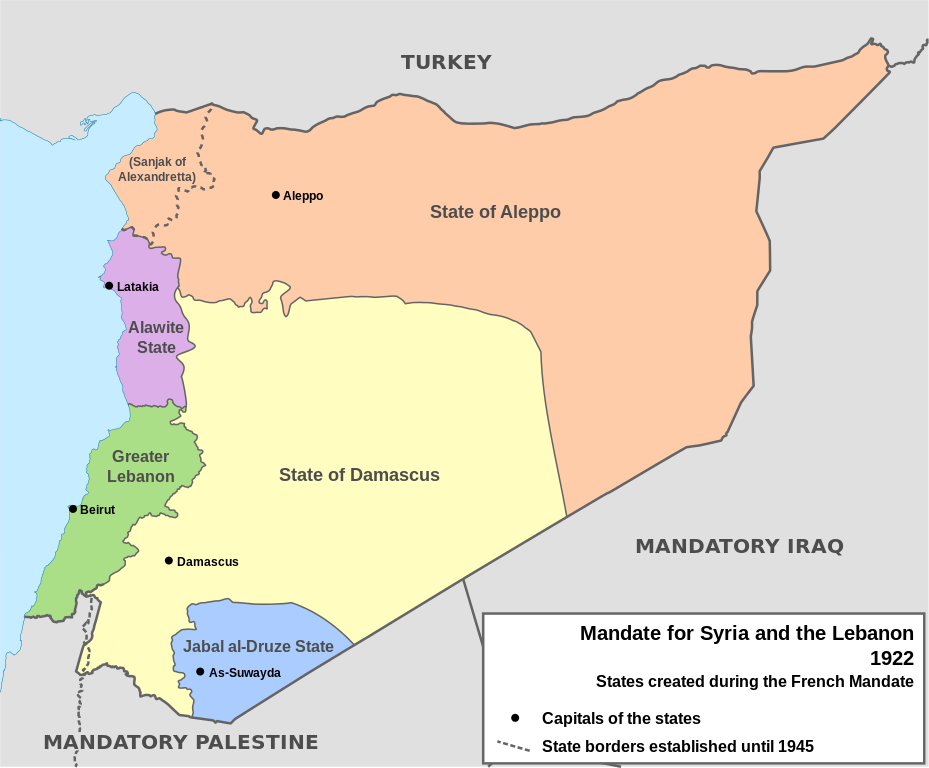
English: Map of French Mandate for Syria and the Lebanon and the states created in 1922, in English. Sources:
|
| Date | |
| Source | Own work, based on File:Syria, administrative divisions - de - colored.svg |
| Author | Don-kun, TUBS, NordNordWest |
| Other versions |
[]
|


Licensing
I, the copyright holder of this work, hereby publish it under the following licenses:

|
Permission is granted to copy, distribute and/or modify this document under the terms of the GNU Free Documentation License, Version 1.2 or any later version published by the Free Software Foundation; with no Invariant Sections, no Front-Cover Texts, and no Back-Cover Texts. A copy of the license is included in the section entitled GNU Free Documentation License. |
This file is licensed under the Creative Commons Attribution 3.0 Unported license.
- You are free:
- to share – to copy, distribute and transmit the work
- to remix – to adapt the work
- Under the following conditions:
- attribution – You must give appropriate credit, provide a link to the license, and indicate if changes were made. You may do so in any reasonable manner, but not in any way that suggests the licensor endorses you or your use.
You may select the license of your choice.
File history
Click on a date/time to view the file as it appeared at that time.
| Date/Time | Thumbnail | Dimensions | User | Comment | |
|---|---|---|---|---|---|
| current | 16:05, 4 February 2013 | | 922 × 762 (245 KB) | AnonMoos | Change "Libanon" to "Lebanon" |
| 15:33, 4 February 2013 |  | 922 × 762 (250 KB) | Don-kun | fix border to palestine, source: http://en.wikisource.org/wiki/Franco-British_Convention_on_Certain_Points_Connected_with_the_Mandates_for_Syria_and_the_Lebanon,_Palestine_and_Mesopotamia | |
| 18:43, 30 January 2013 |  | 922 × 762 (248 KB) | Don-kun | minus ahistorical lakes (and so all waterbodies) | |
| 21:44, 26 January 2013 |  | 922 × 762 (282 KB) | Don-kun | {{Information |Description ={{en|1=Map of French Mandate for Syria and the Lebanon and the states created in 1922, in English.}} |Source ={{own}}, based on File:Syria, administrative divisions - de - colored.svg |Author =[[User:... |
File usage
The following pages on the English Wikipedia use this file (pages on other projects are not listed):
- 1925 Hama uprising
- 1936 Syrian general strike
- Abd al-Rahman Shahbandar
- Al-Jazira Province
- Alawite State
- Alawite revolt of 1919
- Alawites
- Ayyash Al-Haj
- Battle of Maysalun
- Battle of al-Kafr
- Battle of al-Mazraa
- Battle of al-Musayfirah
- Capture of Damascus (1920)
- Capture of Salkhad
- Epic of Ain Albu Gomaa
- Fawzi al-Qawuqji
- Federalization of Syria
- Franco-Syrian Treaty of Independence
- Franco-Syrian War
- Great Syrian Revolt
- Greater Lebanon
- Hananu Revolt
- Haqqi al-Azm
- Hasan al-Kharrat
- Hashim al-Atassi
- Hatay State
- Henri Ponsot
- Henry de Jouvenel
- High Commissioner of the Levant
- History of Lebanon
- History of Syria
- Ibrahim Hananu
- Jabal Druze State
- Jamil Mardam Bey
- Kamil Pasha al-Qudsi
- Khalid al-Azm
- Lebanon
- Lebanon–Syria border
- Lebanon–Syria relations
- Levant Crisis
- Mandate for Syria and the Lebanon
- Mustafa Bey Barmada
- Partition of the Ottoman Empire
- Saleh al-Ali
- Sanjak of Alexandretta
- Shukri al-Quwatli
- State of Aleppo
- State of Damascus
- State of Syria (1925–1930)
- Sultan al-Atrash
- Syria–Lebanon campaign
- Tayfur Sökmen
- Yusuf al-Azma
- User:W144756u/sandbox
- Template:French Mandate of Syria
Global file usage
The following other wikis use this file:
- Usage on af.wikipedia.org
- Usage on ar.wikipedia.org
- Usage on ast.wikipedia.org
- Usage on azb.wikipedia.org
- Usage on az.wikipedia.org
- Usage on be.wikipedia.org
- Usage on bg.wikipedia.org
- Usage on bn.wikipedia.org
- Usage on ca.wikipedia.org
- Usage on cs.wikipedia.org
- Usage on de.wikipedia.org
- Usage on el.wikipedia.org
- Usage on eo.wikipedia.org
- Usage on eu.wikipedia.org
- Usage on fa.wikipedia.org
View more global usage of this file.