
File:French Polynesia relief map with communes.svg

Original file (SVG file, nominally 1,260 × 1,260 pixels, file size: 1.52 MB)
| This is a file from the Wikimedia Commons. Information from its description page there is shown below. Commons is a freely licensed media file repository. You can help. |
Summary
| Description |
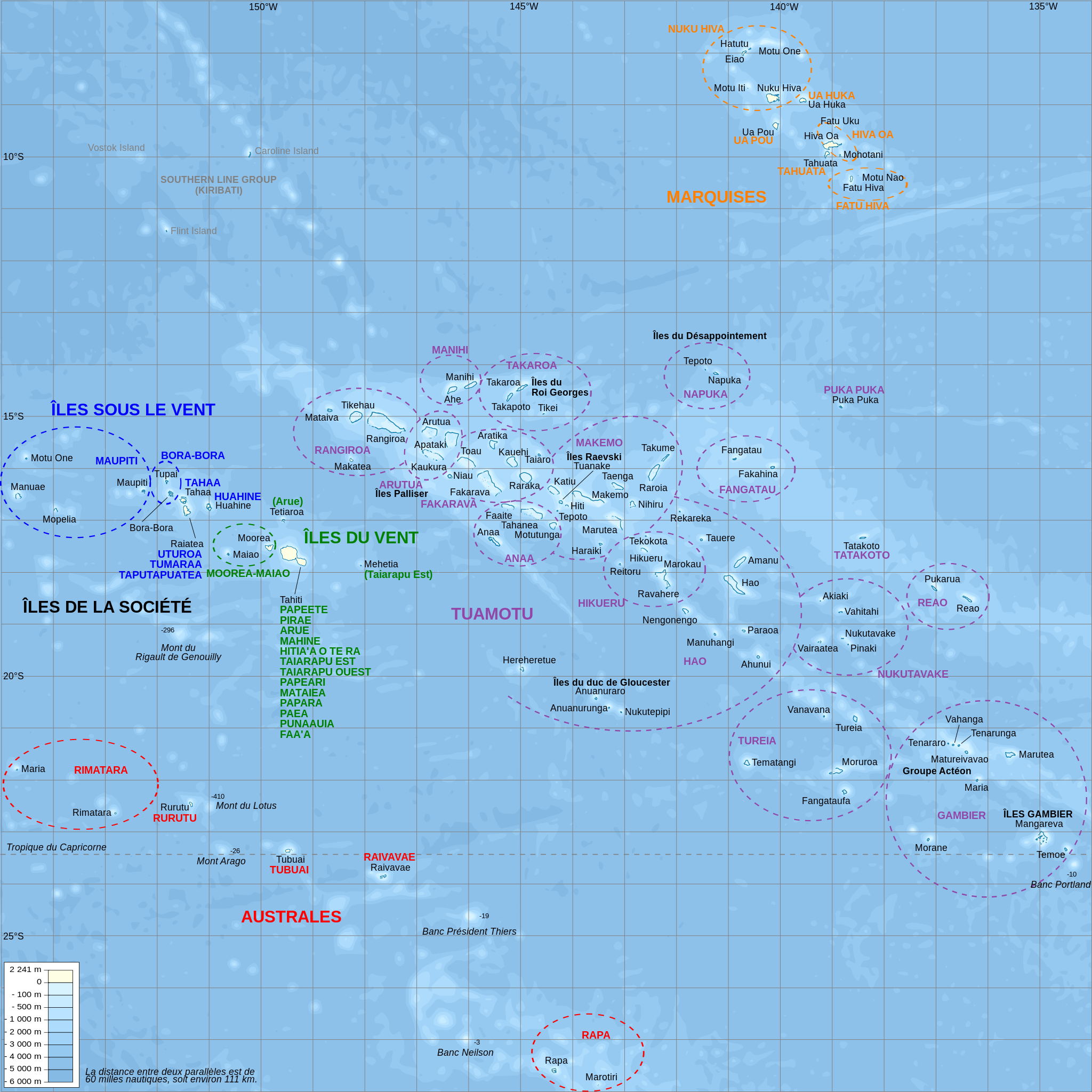
Català: Mapa topogràfic amb noms de subdivisions de la Polinèsia Francesa (en francès)
English: Topographic map with subdivision names of French Polynesia (in French)
Français : Carte topographique de la Polynésie française, en français, avec les noms des subdivisions (communes et archipels) |
| Date | |
| Source |
Own work.
Data sources :
Softwares used :
Others :
|
| Author | L. Claudel (Sardon - fr:Sardon) |
| Other versions |
Other related versions: []
|


|
This SVG file contains embedded text that can be translated into your language, using any capable SVG editor, text editor or the SVG Translate tool. For more information see: About translating SVG files. |
This file is translated using SVG <switch> elements. All translations are stored in the same file! Learn more.
For most Wikipedia projects, you can embed the file normally (without a To translate the text into your language, you can use the Graphics Lab if you're not sure how to do this.
|
Licensing

|
Permission is granted to copy, distribute and/or modify this document under the terms of the GNU Free Documentation License, Version 1.2 or any later version published by the Free Software Foundation; with no Invariant Sections, no Front-Cover Texts, and no Back-Cover Texts. A copy of the license is included in the section entitled GNU Free Documentation License. |
- You are free:
- to share – to copy, distribute and transmit the work
- to remix – to adapt the work
- Under the following conditions:
- attribution – You must give appropriate credit, provide a link to the license, and indicate if changes were made. You may do so in any reasonable manner, but not in any way that suggests the licensor endorses you or your use.
- share alike – If you remix, transform, or build upon the material, you must distribute your contributions under the same or compatible license as the original.
File history
Click on a date/time to view the file as it appeared at that time.
| Date/Time | Thumbnail | Dimensions | User | Comment | |
|---|---|---|---|---|---|
| current | 21:39, 15 February 2024 | | 1,260 × 1,260 (1.52 MB) | Manlleus | File uploaded using svgtranslate tool (https://svgtranslate.toolforge.org/). Added translation for ca. |
| 20:32, 16 October 2008 |  | 1,260 × 1,260 (1.4 MB) | Sardon | {{Information |Description={{en|1=Topographic map with subdivision names of French Polynesia (in French)}} {{fr|1=Carte topographique de la Polynésie française, en français, avec les noms des subdivisions (communes et archipels)}} |Source=Own work.{{cl |
File usage
Global file usage
The following other wikis use this file:
- Usage on af.wikipedia.org
- Usage on als.wikipedia.org
- Usage on ar.wikipedia.org
- Usage on ca.wikipedia.org
- Usage on cs.wikipedia.org
- Usage on de.wikipedia.org
- Usage on de.wikivoyage.org
- Usage on el.wikipedia.org
- Usage on en.wiktionary.org
- Usage on eo.wikipedia.org
- Aŭstralaj Insuloj
- Raroia
- Takume
- Nihiru
- Taenga
- Makemo
- Marutea Nord
- Haraiki
- Katiu
- Tuanake
- Hiti
- Tepoto Sud
- Puka-Puka
- Fakahina
- Fangatau
- Moorea
- Mehetia
- Alventaj Insuloj (Franca Polinezio)
- Maiao
- Ahe
- Manihi
- Takapoto
- Insuloj de reĝo Georgo
- Takaroa
- Tikei
- Rangiroa
- Tikehau
- Mataiva
- Makatea
- Arutua
- Apataki
- Toau
- Fakarava
- Kauehi
- Usage on es.wikipedia.org
View more global usage of this file.