
File:Gaza Strip map.png

Size of this preview: 492 × 600 pixels. Other resolutions: 197 × 240 pixels | 394 × 480 pixels | 984 × 1,200 pixels.
Original file (984 × 1,200 pixels, file size: 343 KB, MIME type: image/png)
| This is a file from the Wikimedia Commons. Information from its description page there is shown below. Commons is a freely licensed media file repository. You can help. |
| Description |
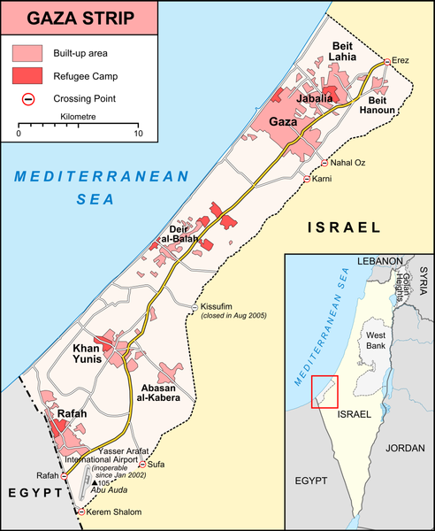
English: Map of Gaza Strip, Stand December 2008 |
|||
| Date | ||||
| Source |
own work, used:
|
|||
| Author | Lencer | |||
| Other versions |
[] Ver1:
Ver2:
|


Licensing
This file is licensed under the Creative Commons Attribution-Share Alike 3.0 Unported license.
- You are free:
- to share – to copy, distribute and transmit the work
- to remix – to adapt the work
- Under the following conditions:
- attribution – You must give appropriate credit, provide a link to the license, and indicate if changes were made. You may do so in any reasonable manner, but not in any way that suggests the licensor endorses you or your use.
- share alike – If you remix, transform, or build upon the material, you must distribute your contributions under the same or compatible license as the original.

|
This map has been made or improved in the German Kartenwerkstatt (Map Lab). You can propose maps to improve as well.
|
File history
Click on a date/time to view the file as it appeared at that time.
| Date/Time | Thumbnail | Dimensions | User | Comment | |
|---|---|---|---|---|---|
| current | 20:42, 6 January 2009 | | 984 × 1,200 (343 KB) | Lencer | {{Information |Description= |Source= |Date= |Author= |Permission= |other_versions= }} |
| 20:06, 6 January 2009 |  | 984 × 1,200 (343 KB) | Lencer | {{Information| |Description=Map of Gaza Strip, Stand December 2008 |Source=own work, used: * [http://unosat.web.cern.ch/unosat/asp/prod_free.asp?pid=1304 UNOSAT, Situation Map-Gaza Crisis] * [http://www.ochaopt.org/gazacrisis/admin/outp |
File usage
The following pages on the English Wikipedia use this file (pages on other projects are not listed):
Global file usage
The following other wikis use this file:
- Usage on be.wikipedia.org
- Usage on da.wikipedia.org
- Usage on de.wikipedia.org
- Usage on de.wikinews.org
- Usage on fr.wikipedia.org
- Usage on hy.wikipedia.org
- Usage on li.wikinews.org
- Usage on no.wikipedia.org
- Usage on ru.wikipedia.org
- Usage on sv.wikipedia.org
- Usage on tt.wikipedia.org
- Usage on vep.wikipedia.org