
File:Gz-map.png
No higher resolution available.
Gz-map.png (330 × 354 pixels, file size: 13 KB, MIME type: image/png)
| This is a file from the Wikimedia Commons. Information from its description page there is shown below. Commons is a freely licensed media file repository. You can help. |
Summary
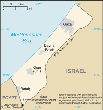
| Description |
English: A map of the Gaza Strip showing key towns and neighbouring countries. |
|||
| Source | Gaza Strip from CIA factbook | |||
| Author | CIA | |||
| Other versions |
[] Ver1:
Ver2:
|


Licensing
This image is in the public domain because it contains materials that originally came from the United States Central Intelligence Agency's World Factbook.
|
 |
File history
Click on a date/time to view the file as it appeared at that time.
| Date/Time | Thumbnail | Dimensions | User | Comment | |
|---|---|---|---|---|---|
| current | 10:24, 12 December 2008 | | 330 × 354 (13 KB) | Mattflaschen | Put back latest image from Factbook. This includes the note (don't know whether it was there on December 2, 2007). |
| 02:17, 2 December 2007 |  | 328 × 352 (8 KB) | Kordas | Updated map | |
CIA World Factbook website on 15 August 2005. Public domain , as is all content from the CIA factbook. | |||||
CIA World Factbook website on 12 April. Public domain , as is all content from |
File usage
The following pages on the English Wikipedia use this file (pages on other projects are not listed):
Global file usage
The following other wikis use this file:
- Usage on arz.wikipedia.org
- Usage on be.wikipedia.org
- Usage on bn.wikipedia.org
- Usage on br.wikipedia.org
- Usage on bs.wikipedia.org
- Usage on bs.wikinews.org
- Usage on ca.wikipedia.org
- Usage on cs.wikinews.org
- Usage on da.wikipedia.org
- Usage on de.wikinews.org
- Usage on en.wikinews.org
- Israeli army kills three Egyptians in border incident
- Abbas wins election, offers Israel 'hand of peace'
- Wikinews:2005/January
- Wikinews:2005/January/13
- K'nesset Member Natan Sharansky resigns from coalition government to protest planned Gaza withdrawal
- Israeli Air Force attacks targets in Gaza
- Israeli greenhouses to be preserved after Gaza pullout
- Gaza Strip pullout under way
- Israeli Army begins forced evacuation of Gaza settlements
- Palestinian gunmen assassinate ex-security chief
- Israel completing Gaza withdrawal
- Israel Defense Forces attack Gaza Strip
- Israel releases 90 Palestinian prisoners
- Israeli air strikes hit government compounds in Gaza
- Palestinian president pleads with UN Security Council for help in Gaza
- Usage on en.wikivoyage.org
- Usage on eo.wikipedia.org
- Usage on es.wikipedia.org
- Usage on es.wikinews.org
- Usage on eu.wikipedia.org
- Usage on fr.wikipedia.org
- Usage on fr.wikinews.org
- Usage on gl.wikipedia.org
- Usage on he.wikipedia.org
- Usage on he.wikinews.org
- Usage on hr.wikipedia.org
- Usage on id.wikipedia.org
View more global usage of this file.