
File:Hildreth Covered Bridge.jpg

Size of this preview: 800 × 525 pixels. Other resolutions: 320 × 210 pixels | 640 × 420 pixels | 1,024 × 672 pixels | 1,280 × 840 pixels.
Original file (1,280 × 840 pixels, file size: 368 KB, MIME type: image/jpeg)
| This is a file from the Wikimedia Commons. Information from its description page there is shown below. Commons is a freely licensed media file repository. You can help. |
|
This is an image of a place or building that is listed on the National Register of Historic Places in the United States of America. Its reference number is 78002211. |
| Camera location | | View this and other nearby images on: OpenStreetMap |
|---|
| Description |
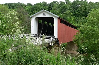
English: Western end of the Hildreth Covered Bridge (also known as the "Hills Covered Bridge"), which formerly carried Hills Bridge Road over the Little Muskingum River east of Marietta in Newport Township, Washington County, Ohio, United States. Built in 1879, this Howe Truss covered bridge is listed on the National Register of Historic Places. |
| Date | |
| Source | Flickr |
| Author | Linda Tanner |
| Permission (Reusing this file) |
This file is licensed under the Creative Commons Attribution 2.0 Generic license.
|
| This image was originally posted to Flickr by goingslo at https://www.flickr.com/photos/15323831@N05/2455989736. It was reviewed on 16 December 2010 by FlickreviewR and was confirmed to be licensed under the terms of the cc-by-2.0. |
File history
Click on a date/time to view the file as it appeared at that time.
| Date/Time | Thumbnail | Dimensions | User | Comment | |
|---|---|---|---|---|---|
| current | 00:52, 16 December 2010 | | 1,280 × 840 (368 KB) | Nyttend | {{Location|39|25|38|N|81|21|42|W}} {{Information |Description={{en|One end of the {{w|Hildreth Covered Bridge}} (also known as the "Hills Covered Bridge"), which formerly carried Hills Bridge Road over the {{w|Little Muskingum River}} east of {{w|Marietta |
File usage
The following pages on the English Wikipedia use this file (pages on other projects are not listed):
Global file usage
The following other wikis use this file:
- Usage on es.wikipedia.org
- Usage on eu.wikipedia.org
- Usage on fa.wikipedia.org
- Usage on ja.wikipedia.org
- Usage on pt.wikipedia.org
- Usage on vi.wikipedia.org
- Usage on www.wikidata.org
- Usage on zh.wikipedia.org