
File:Ireland geographical map.png
No higher resolution available.
Ireland_geographical_map.png (150 × 190 pixels, file size: 50 KB, MIME type: image/png)
| This is a file from the Wikimedia Commons. Information from its description page there is shown below. Commons is a freely licensed media file repository. You can help. |
| Description |
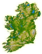
English: Topography of Ireland |
| Date | IotD Date 2005-03-18 |
| Source |
NASA: IotD ID 16853 – http://visibleearth.nasa.gov/view_rec.php?id=17124 |
| Author | NASA, see Image:Topography Ireland.jpg for more information |
| Permission (Reusing this file) |
public domain |
| Other versions | original, bigger version at Image:Topography Ireland.jpg |
| This file is in the public domain in the United States because it was solely created by NASA. NASA copyright policy states that "NASA material is not protected by copyright unless noted". (See Template:PD-USGov, NASA copyright policy page or JPL Image Use Policy.) | ||
 |
Warnings:
|
File history
Click on a date/time to view the file as it appeared at that time.
| Date/Time | Thumbnail | Dimensions | User | Comment | |
|---|---|---|---|---|---|
| current | 11:39, 11 July 2005 | | 150 × 190 (50 KB) | Kanchelskis | Map of Ireland lightened. Author:me {{GFDL}} Category: Ireland |
File usage
More than 100 pages use this file. The following list shows the first 100 pages that use this file only. A full list is available.
- Ards Peninsula
- Beara Peninsula
- Dingle Peninsula
- Fanad
- Hook Peninsula
- Horn Head
- Howth Head
- Inishowen
- Islandmagee
- Iveragh Peninsula
- Mizen Head
- Mullaghmore, County Sligo
- Mullet Peninsula
- Old Head of Kinsale
- Rosguill
- Sheep's Head
- Slieve League
- User:Afn
- User:AndrewH
- User:Ant ie
- User:ApeXaviour
- User:Autarch
- User:BBX
- User:Bastion
- User:Bastun
- User:Ben-w
- User:Bjimba
- User:Blorg
- User:Blorgina
- User:Brendanconway/userboxes
- User:Camaderry
- User:Ciand
- User:Cliphwinters
- User:Colm Rice
- User:Colossus 86
- User:Conor~enwiki
- User:Conqueror Hibernensis
- User:Damac
- User:Dermo69
- User:Derry Boi
- User:Dkie
- User:Dmitrysimpson
- User:Dowlingm
- User:Durrus
- User:Ebelular
- User:Feena.D
- User:Fergananim
- User:Fergus mac Róich
- User:Frure
- User:George McFinnigan ie
- User:Gerry Lynch
- User:Hetch
- User:Hibernian
- User:Ian Cheese
- User:Irlchrism
- User:Jamesnp
- User:Jasonm
- User:Jdorney
- User:Joe Byrne
- User:John Carroll
- User:Jorgenpfhartogs
- User:Jtdirl
- User:KC.
- User:KaptKos
- User:Kenguest
- User:Kgaughan
- User:Kwekubo
- User:Lewismistreated
- User:Lochdale
- User:Lugnad
- User:Meabhar~enwiki
- User:Merlante
- User:Mp3guy
- User:Nosmo
- User:Notjim
- User:Padraig
- User:Polar ice
- User:Raemie
- User:Rbreen
- User:Ropers
- User:Ryano
- User:Rye 212
- User:Saebhiar
- User:Sean3000
- User:Seneschally
- User:Setanta747
- User:Sgt baker
- User:Stifle
- User:Thebdogg
- User:Tiocfaidh Ár Lá
- User:Tpower
- User:Trevis~enwiki
- User:Tír Eoghain abú
- User:Ventolin
- User:Wexfordman
- User:Wikipedian231
- User:Ww2censor
- User:Zoney
- User talk:Ellenah
- User talk:Lochaber
View more links to this file.
Global file usage
The following other wikis use this file:
- Usage on de.wikipedia.org
- Usage on incubator.wikimedia.org
- Usage on it.wikipedia.org
- Baia di Donegal
- Baia di Galway
- Baia di Clew
- Killary Harbour
- Lough Foyle
- Baia di Killala
- Baia di Bunatrahir
- Portale:Irlanda
- Portale:Irlanda/Temi
- Baia di Sligo
- Template:Baie irlandesi
- Broad Haven
- Baia di Lackan
- Baia di Blacksod
- Baia di Tullaghan
- Ballynakill Harbour
- Baia di Cleggan
- Baia di Streamstown
- Baia di Clifden
- Baia di Mannin
- Baia di Ballyconneely
- Baia di Bertraghboy
- Baia di Kilkieran
- Baia di Cashla
- Baia di Liscannor
- Mal Bay
- Baia di Moore
- Foce dello Shannon
- Baia di Ballyheige
- Baia di Tralee
- Baia di Brandon
- Baia di Ard na Caithne
- Baia di Dingle
- Baia di Doulus
- Baia di San Finan
- Baia di Ballinskelligs
- Kenmare River
- Baia di Ballydonegan
- Baia di Bantry
- Baia di Dublino
- Lough Swilly
- Belfast Lough
- Baia di Malin
- Baia di Glen
- Baia di Dundalk
- Usage on nrm.wikipedia.org
- Usage on vec.wikipedia.org
View more global usage of this file.