
File:Kanagawa AshigaraKami-gun.png
Kanagawa_AshigaraKami-gun.png (190 × 110 pixels, file size: 4 KB, MIME type: image/png)
| This is a file from the Wikimedia Commons. Information from its description page there is shown below. Commons is a freely licensed media file repository. You can help. |
Summary
| Description |
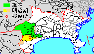
English: Map of Ashigarakami District, Kanagawa, Japan
日本語: 神奈川県足柄上郡の範囲:緑色が現在の範囲(1.中井町 2.大井町 3.松田町 4.山北町 5.開成町)、黄色が明治時代中期の範囲 |
||
| Date | |||
| Source | Map_kanagawa_ashigarakami_district_p01-01.png と JpLargeMap_KantoTokai.png を元に投稿者が作成 | ||
| Author |
|
||
| Permission (Reusing this file) |
|
Licensing

|
Permission is granted to copy, distribute and/or modify this document under the terms of the GNU Free Documentation License, Version 1.2 or any later version published by the Free Software Foundation; with no Invariant Sections, no Front-Cover Texts, and no Back-Cover Texts. A copy of the license is included in the section entitled GNU Free Documentation License. |
- You are free:
- to share – to copy, distribute and transmit the work
- to remix – to adapt the work
- Under the following conditions:
- attribution – You must give appropriate credit, provide a link to the license, and indicate if changes were made. You may do so in any reasonable manner, but not in any way that suggests the licensor endorses you or your use.
- share alike – If you remix, transform, or build upon the material, you must distribute your contributions under the same or compatible license as the original.
Original upload log
- 2014-03-22 17:53 検見川町 190×110× (3717 bytes) 他県と縮尺を合わせて全面改訂。
- 2008-12-28 15:22 Okia 420×210× (13835 bytes)
- 2008-12-20 20:58 Okia 420×210× (11185 bytes) Ma{{Information |Description=明治時代中頃の足柄上郡 |Source= Map_kanagawa_ashigarakami_district_p01-01.png を元に投稿者が作成 |Date= 20081221 |Author= okia |Permission= {{GFDL}} |other_versions= }}
- 2008-12-20 20:43 Okia 420×210× (11200 bytes) Ma{{Information |Description=明治時代中頃の足柄上郡 |Source= Map_kanagawa_ashigarakami_district_p01-01.png を元に投稿者が作成 |Date= 20081221 |Author= okia |Permission= {{GFDL}} |other_versions= }}
- 2004-08-04 20:01 Tai i 420×210× (8001 bytes) 神奈川県足柄上郡の位置図, 420x210, 8KB, 7
File history
Click on a date/time to view the file as it appeared at that time.
| Date/Time | Thumbnail | Dimensions | User | Comment | |
|---|---|---|---|---|---|
| current | 07:59, 7 October 2020 | | 190 × 110 (4 KB) | OgreBot | (BOT): Reverting to most recent version before archival |
| 07:59, 7 October 2020 |  | 420 × 210 (11 KB) | OgreBot | (BOT): Uploading old version of file from ja.wikipedia; originally uploaded on 2008-12-20 20:58:44 by Okia | |
| 07:58, 7 October 2020 |  | 420 × 210 (11 KB) | OgreBot | (BOT): Uploading old version of file from ja.wikipedia; originally uploaded on 2008-12-20 20:43:38 by Okia | |
| 07:58, 7 October 2020 |  | 420 × 210 (8 KB) | OgreBot | (BOT): Uploading old version of file from ja.wikipedia; originally uploaded on 2004-08-04 20:01:05 by Tai i | |
| 05:46, 10 April 2014 |  | 190 × 110 (4 KB) | 検見川町 | 他県と縮尺を合わせて全面改訂。 | |
| 17:53, 22 March 2014 |  | 190 × 110 (4 KB) | 検見川町 | 他県と縮尺を合わせて全面改訂。 | |
| 02:09, 13 August 2009 |  | 420 × 210 (14 KB) | MChew | {{Information| |Description=Map of Ashigarakami District, Kanagawa, Japan |Source= ja:Map kanagawa ashigarakami district p01-01.png on Japanese Wikipedia |Date=2008-12-28 |Author=okia on Japanese Wikipedia |Permission={{GFDL-ja}} |o | |
| 15:22, 28 December 2008 |  | 420 × 210 (14 KB) | Okia | Suppressed comment removed by FileImporter. | |
| 20:58, 20 December 2008 |  | 420 × 210 (11 KB) | Okia | Ma{{Information |Description=明治時代中頃の足柄上郡 |Source= Map_kanagawa_ashigarakami_district_p01-01.png を元に投稿者が作成 |Date= 20081221 |Author= okia |Permission= {{GFDL}} |other_versions= }} | |
| 20:43, 20 December 2008 |  | 420 × 210 (11 KB) | Okia | Ma{{Information |Description=明治時代中頃の足柄上郡 |Source= Map_kanagawa_ashigarakami_district_p01-01.png を元に投稿者が作成 |Date= 20081221 |Author= okia |Permission= {{GFDL}} |other_versions= }} |
File usage
Global file usage
The following other wikis use this file:
- Usage on ar.wikipedia.org
- Usage on fa.wikipedia.org
- Usage on fr.wikipedia.org
- Usage on ja.wikipedia.org
- Usage on ko.wikipedia.org
- Usage on ru.wikipedia.org
- Usage on th.wikipedia.org
- Usage on uk.wikipedia.org
- Usage on www.wikidata.org