
File:Karte der Einzugsgebiete der großen Gewässer Afrikas.png

Size of this preview: 634 × 599 pixels. Other resolutions: 254 × 240 pixels | 508 × 480 pixels | 813 × 768 pixels | 1,084 × 1,024 pixels | 1,525 × 1,441 pixels.
Original file (1,525 × 1,441 pixels, file size: 296 KB, MIME type: image/png)
| This is a file from the Wikimedia Commons. Information from its description page there is shown below. Commons is a freely licensed media file repository. You can help. |
Summary
| Description |
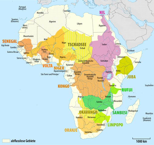
Deutsch: Karte der Einzugsgebiete der großen Gewässer Afrikas
English: Map of the main river systems in Africa |
|||
| Date | see file history | |||
| Source | Own work, using this file by Sting | |||
| Author | Maximilian Dörrbecker (Chumwa) | |||
| Permission (Reusing this file) |
This file is licensed under the Creative Commons Attribution-Share Alike 2.0 Generic license.
Sie dürfen das Bild zu den folgenden Bedingungen nutzen:
|
File history
Click on a date/time to view the file as it appeared at that time.
| Date/Time | Thumbnail | Dimensions | User | Comment | |
|---|---|---|---|---|---|
| current | 06:03, 19 September 2014 | | 1,525 × 1,441 (296 KB) | Kopiersperre | optipng |
| 12:00, 30 August 2014 |  | 1,525 × 1,441 (458 KB) | Chumwa | ||
| 21:34, 28 August 2014 |  | 1,525 × 1,441 (423 KB) | Chumwa | == {{int:filedesc}} == {{Information |Description = {{de|1=Karte der Einzugsgebiete der großen Gewässer Afrikas}} {{en|1=Map of the main river systems in Africa}} |Source={{own}}, using this file by {{U|Sting}} |... |
File usage
The following pages on the English Wikipedia use this file (pages on other projects are not listed):
Global file usage
The following other wikis use this file:
- Usage on af.wikipedia.org
- Usage on ca.wikipedia.org
- Usage on da.wikipedia.org
- Usage on de.wikipedia.org
- Usage on es.wikipedia.org
- Usage on fr.wikipedia.org
- Usage on io.wikipedia.org
- Usage on ja.wikipedia.org
- Usage on lt.wikipedia.org
- Usage on sw.wikipedia.org
- Usage on uk.wikipedia.org