
File:Khangchendzonga np.jpg

Size of this preview: 476 × 599 pixels. Other resolutions: 191 × 240 pixels | 381 × 480 pixels | 610 × 768 pixels | 813 × 1,024 pixels | 1,627 × 2,048 pixels | 5,213 × 6,562 pixels.
Original file (5,213 × 6,562 pixels, file size: 2.92 MB, MIME type: image/jpeg)
| This is a file from the Wikimedia Commons. Information from its description page there is shown below. Commons is a freely licensed media file repository. You can help. |
Summary
| Description |
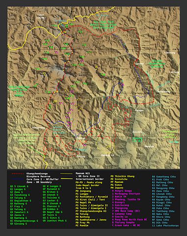
English: Contour generated by software from free SRTM data |
| Date |
26 September 2008 28 September 2008 (original upload date) |
| Source | Transferred from en.wikipedia to Commons by Hike395 using CommonsHelper. |
| Author | ray (talk · contribs) |
Licensing
ray, the copyright holder of this work, hereby publishes it under the following license:

|
Permission is granted to copy, distribute and/or modify this document under the terms of the GNU Free Documentation License, Version 1.2 or any later version published by the Free Software Foundation; with no Invariant Sections, no Front-Cover Texts, and no Back-Cover Texts. A copy of the license is included in the section entitled GNU Free Documentation License. |
| This file is licensed under the Creative Commons Attribution-Share Alike 3.0 Unported license. | ||
| Attribution: ray | ||
| ||
| This licensing tag was added to this file as part of the GFDL licensing update. |
Original upload log
The original description page was here. All following user names refer to en.wikipedia.
- 2008-09-28 20:04 Pradiptaray 5213×6562× (3057157 bytes) {{Information |Description=I made the map. Contour generated by software from free SRTM data |Source=I created this work entirely by myself. |Date=26 Sep, 2008 |Author=[[User:Pradiptaray|ray]] ([[User talk:Pradiptaray|talk]]) |other_versions= }} ==Licens
- 2008-09-28 19:18 Pradiptaray 5213×6724× (3113277 bytes) {{Information |Description=I made the map. Contour generated by software from free SRTM data |Source=I created this work entirely by myself. |Date=26 Sep, 2008 |Author=~~~ |other_versions= }}
| Annotations | This image is annotated: View the annotations at Commons |
File history
Click on a date/time to view the file as it appeared at that time.
| Date/Time | Thumbnail | Dimensions | User | Comment | |
|---|---|---|---|---|---|
| current | 12:31, 14 June 2012 | | 5,213 × 6,562 (2.92 MB) | Hike395 | {{Information |Description = {{en|Pradiptaray made the map. Contour generated by software from free SRTM data}} |Source =Pradiptaray at en.wikipedia |Date = {{date|2008|09|26}} — {{original upload... |
| 12:29, 14 June 2012 |  | 5,213 × 6,562 (2.92 MB) | File Upload Bot (Magnus Manske) | Transfered from en.wikipedia by User:Hike395 using CommonsHelper |
File usage
The following pages on the English Wikipedia use this file (pages on other projects are not listed):
Global file usage
The following other wikis use this file:
- Usage on as.wikipedia.org
- Usage on be.wikipedia.org
- Usage on bn.wikipedia.org
- Usage on es.wikipedia.org
- Usage on fa.wikipedia.org
- Usage on hi.wikipedia.org
- Usage on ja.wikipedia.org
- Usage on kn.wikipedia.org
- Usage on mk.wikipedia.org
- Usage on nn.wikipedia.org
- Usage on ro.wikipedia.org
- Usage on sl.wikipedia.org
- Usage on ur.wikipedia.org
- Usage on zh.wikipedia.org