
File:Kimberlite Pipes in Africa.png

Size of this preview: 671 × 600 pixels. Other resolutions: 268 × 240 pixels | 537 × 480 pixels | 680 × 608 pixels.
Original file (680 × 608 pixels, file size: 74 KB, MIME type: image/png)
| This is a file from the Wikimedia Commons. Information from its description page there is shown below. Commons is a freely licensed media file repository. You can help. |
Summary
| Description |
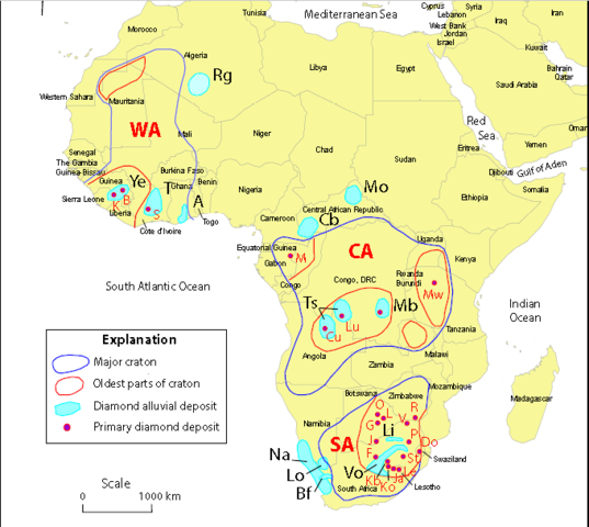
English: Map of Africa showing the distribution of diamond deposits with repect to cratons (outlined in blue) and their most ancient rock units (outlined in red). Note that economic kimberlites are found only on those ancient parts of cratons. Red dots and red letters are kimberlite bodies, and light blue areas with black letters are alluvial deposits (note that some areas contain both kimberlite bodies and alluvial deposits). Key to large red letters: CA--Central African (Kasai) craton; SA--South African (Kalahari) craton; WA--West African craton. Key to solid red and black letter: A--Akwatia/Birim alluvials; B--Banankoro alluvials and bodies; Bf--Buffels River alluvials; Cb--Carnot/Berberati alluvials; Cu--Cuango Valley alluvials and bodies; Do--Dokolwayo body; F--Finsch body; G--Gope body; J--Kwaneng body; Ja--Jagersfontein body;K--Koidu body; Kb--Kimberley bodies (5); Ko--Koffiefontein body; L--Letlhakane body; Le--Letseng body; Li--Lichtenburg alluvials; Lo--Lower Orange River alluvials; Lu--Lunda bodies and alluvials: M--Mitzic bodies; Mb--Mbuji- . Mayi bodies and alluvials; Mo--Mouka Ouadda alluvials; Mw--Mwadui body; Na--beach and offshore alluvials along Namibia and Namaqualand coast; O--Orapa body; P--Primier body; R--River Ranch body; T--Tortiya alluvials; Ts--Tshikapa alluvials; V--Venetia body; Vo--Vaal/Orange Rivers alluvials; Ye--Yengema alluvials. Map from Janse, (1996). |
| Date | |
| Source | Geology and nonfuel mineral deposits of Africa and the Middle East, USGS Open-File Report 2005-1294-E, page 242, figure 10M. |
| Author | Taylor, C.D., Schulz, K.J., Doebrich, J.L., Orris, G.J., Denning, P.D., and Kirschbaum, M.J. |
Licensing
This image is in the public domain in the United States because it only contains materials that originally came from the United States Geological Survey, an agency of the United States Department of the Interior. For more information, see the official USGS copyright policy.
|
File history
Click on a date/time to view the file as it appeared at that time.
| Date/Time | Thumbnail | Dimensions | User | Comment | |
|---|---|---|---|---|---|
| current | 18:37, 20 February 2017 | | 680 × 608 (74 KB) | Pi3.124 | User created page with UploadWizard |
File usage
The following pages on the English Wikipedia use this file (pages on other projects are not listed):
Global file usage
The following other wikis use this file:
- Usage on bg.wikipedia.org