
File:Kingdom of Galicia.png
No higher resolution available.
Kingdom_of_Galicia.png (613 × 600 pixels, file size: 155 KB, MIME type: image/png)
| This is a file from the Wikimedia Commons. Information from its description page there is shown below. Commons is a freely licensed media file repository. You can help. |
| Description |
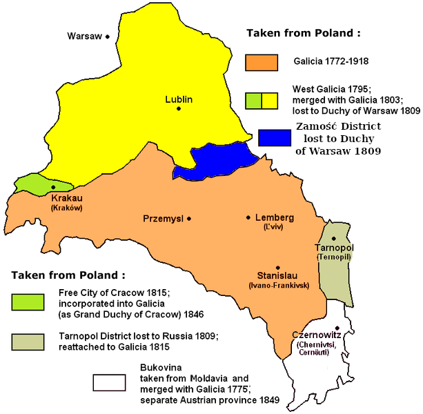
Kingdom of Galicia and Lodomerania, with New (West) Galicia, Free City of Kraków, Tarnopol District and Bukovina
|
| Date | Uploaded to en wiki on 22:58, January 18, 2005 |
| Source | Unknown source, unknown copyright situation |
| Author | User:Kpalion |
| Permission (Reusing this file) |
GFDL |
| Other versions | Derivative works of this file: ReinoDeGalitzia.svg |

|
This historical map image could be re-created using vector graphics as an SVG file. This has several advantages; see Commons:Media for cleanup for more information. If an SVG form of this image is available, please upload it and afterwards replace this template with
{{vector version available|new image name}}.
It is recommended to name the SVG file “Kingdom of Galicia.svg”—then the template Vva ) does not need the new image name parameter. |
Made by Kpalion

|
Permission is granted to copy, distribute and/or modify this document under the terms of the GNU Free Documentation License, Version 1.2 or any later version published by the Free Software Foundation; with no Invariant Sections, no Front-Cover Texts, and no Back-Cover Texts. A copy of the license is included in the section entitled GNU Free Documentation License. |
| This file is licensed under the Creative Commons Attribution-Share Alike 3.0 Unported license. | ||
| ||
| This licensing tag was added to this file as part of the GFDL licensing update. |
File history
Click on a date/time to view the file as it appeared at that time.
| Date/Time | Thumbnail | Dimensions | User | Comment | |
|---|---|---|---|---|---|
| current | 08:46, 30 October 2019 | | 613 × 600 (155 KB) | D T G | added Zamość District, part of the 1772 partition, lost in 1809 to Duchy of Warsaw |
| 20:28, 15 March 2011 |  | 613 × 600 (125 KB) | Mitica-Misha | Rectified map (about Bukovina) Category:Maps Category:History of Poland Category:Austria-Hungary | |
| 12:59, 19 July 2007 |  | 742 × 726 (50 KB) | Piotrus | {{Information |Description=Kingdom of Galicia and Lodomerania, with New (West) Galicia, Free City of Kraków, Tarnopol District and Bukovina |Source= |Date=Uploaded to en wiki on 22:58, January 18, 2005 |Author=User:Kpalion |Permission=GFDL |other_ve | |
| 21:01, 18 January 2005 |  | 742 × 726 (50 KB) | Kpalion | {{GFDL} |
File usage
The following pages on the English Wikipedia use this file (pages on other projects are not listed):
Global file usage
The following other wikis use this file:
- Usage on be.wikipedia.org
- Usage on ca.wikipedia.org
- Usage on cs.wikipedia.org
- Usage on da.wikipedia.org
- Usage on de.wikipedia.org
- Usage on el.wikipedia.org
- Usage on eo.wikipedia.org
- Usage on es.wikipedia.org
- Usage on fi.wikipedia.org
- Usage on fr.wikipedia.org
- Usage on gl.wikipedia.org
- Usage on he.wikipedia.org
- Usage on hu.wikipedia.org
- Usage on id.wikipedia.org
- Usage on it.wikipedia.org
- Usage on ja.wikipedia.org
- Usage on ka.wikipedia.org
- Usage on lt.wikipedia.org
- Usage on lv.wikipedia.org
- Usage on nl.wikipedia.org
- Usage on nn.wikipedia.org
- Usage on no.wikipedia.org
- Usage on pt.wikipedia.org
- Usage on ro.wikipedia.org
- Usage on rue.wikipedia.org
- Usage on ru.wikipedia.org
- Usage on sh.wikipedia.org
- Usage on sk.wikipedia.org
- Usage on sr.wikipedia.org
- Usage on yi.wikipedia.org
- Usage on zh.wikipedia.org