
File:Korean war 1950-1953.gif
Size of this preview: 387 × 600 pixels. Other resolutions: 155 × 240 pixels | 562 × 871 pixels.
Original file (562 × 871 pixels, file size: 1.32 MB, MIME type: image/gif, looped, 20 frames, 30 s)
| This is a file from the Wikimedia Commons. Information from its description page there is shown below. Commons is a freely licensed media file repository. You can help. |

Summary
| Description |
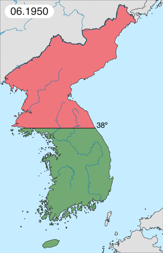
English: Map of Korean war from May 1950 to July 1951, showing:
Français : Carte de la guerre de Corée de mai 1950 à juillet 1951, montrant:
Deutsch: Karte des Koreakriegs von Mai 1950 bis Juli 1951, abgebildet:
Italiano: Mappa della guerra di Corea dal maggio 1950 al luglio 1951, rappresentante:
|
| Date | |
| Source | Own work |
| Author | Leomonaci98 |
Licensing
I, the copyright holder of this work, hereby publish it under the following licenses:

|
Permission is granted to copy, distribute and/or modify this document under the terms of the GNU Free Documentation License, Version 1.2 or any later version published by the Free Software Foundation; with no Invariant Sections, no Front-Cover Texts, and no Back-Cover Texts. A copy of the license is included in the section entitled GNU Free Documentation License. |
| This file is licensed under the Creative Commons Attribution-Share Alike 3.0 Unported license. | ||
| ||
| This licensing tag was added to this file as part of the GFDL licensing update. |
You may select the license of your choice.
File history
Click on a date/time to view the file as it appeared at that time.
| Date/Time | Thumbnail | Dimensions | User | Comment | |
|---|---|---|---|---|---|
| current | 20:20, 16 February 2020 | | 562 × 871 (1.32 MB) | Leomonaci98 | Graphic update |
| 01:02, 1 May 2013 |  | 227 × 400 (85 KB) | Spesh531 | update for every month | |
| 08:47, 9 June 2006 |  | 227 × 400 (37 KB) | Roke~commonswiki | rm white | |
| 06:25, 8 June 2006 |  | 227 × 400 (37 KB) | Roke~commonswiki | add OngJin peninsula after comment, also blank frame at end | |
| 15:14, 5 June 2006 |  | 227 × 400 (37 KB) | Roke~commonswiki | Korean war, showing North Korean, Chinese and communist forces (red); South Korean, US and United Nations forces (green). Category: Korean War Category: Animated maps |
File usage
More than 100 pages use this file. The following list shows the first 100 pages that use this file only. A full list is available.
- 1950 in the United States
- 25th Canadian Infantry Brigade
- 2 Squadron SAAF
- Aftermath of World War II
- Aftermath of the Korean War
- Attack on the Sui-ho Dam
- Australia in the Korean War
- Battle of Bloody Ridge
- Battle of Chipyong-ni
- Battle of Chongju (1950)
- Battle of Chosin Reservoir
- Battle of Chumonchin Chan
- Battle of Heartbreak Ridge
- Battle of Inchon
- Battle of Kapyong
- Battle of Kujin
- Battle of Onjong
- Battle of Osan
- Battle of Pakchon
- Battle of Pork Chop Hill
- Battle of Pyongtaek
- Battle of Sunchon (air)
- Battle of Taejon
- Battle of Triangle Hill
- Battle of Unsan
- Battle of Wawon
- Battle of Yongyu
- Battle of the Ch'ongch'on River
- Battle of the Imjin River
- Battle of the Pusan Perimeter
- Battle of the Samichon River
- Battle on Shangganling Mountain (film)
- Blockade of Wonsan
- Bout One
- British Commonwealth Forces Korea
- Colder Than Hell
- Crèvecoeur (film)
- First Battle of Maryang-san
- Five Marines
- French Battalion
- Gangneung Air Base
- Greek Expeditionary Force (Korea)
- Haeju Airport
- III Corps (South Korea)
- Italian Red Cross
- Jamestown Line
- Japanese War Bride
- Joint Advisory Commission, Korea
- K1c2 formula
- Kagnew Battalion
- Korean Airlift
- Korean War
- Korean War order of battle
- Korean War reenactment
- Korean conflict
- List of American and British defectors in the Korean War
- List of Korean War flying aces
- List of Korean War weapons
- List of M*A*S*H novels
- List of Puerto Ricans missing in action in the Korean War
- List of documentary films about the Korean War
- MS Jutlandia
- Marines, Let's Go
- MiG Alley
- National Production Authority
- New Zealand in the Korean War
- North Korea
- North Korea–South Korea relations
- One Who Came Back
- Orang Airport
- Order of battle of Australian forces during the Korean War
- Parachute Regiment (India)
- People's Volunteer Army
- Philippine Expeditionary Forces to Korea
- Presidency of Harry S. Truman
- Pyongyang Sally
- Regiment van Heutsz
- Royal Australian Regiment
- Shadow Warriors (Breuer book)
- Silver Stallion (1991 film)
- Sokcho Airport
- The Coldest Winter: America and the Korean War
- The Crime of Korea
- The Marines Who Never Returned
- The Nun and the Sergeant
- The Vicar of Christ
- Timeline of Korean history
- Turkish Brigade
- U.S. Eighth Army Korean War order of battle
- U.S. Seventh Fleet Korean War order of battle
- USAF units and aircraft of the Korean War
- United Nations Command
- United Nations Commission for the Unification and Rehabilitation of Korea
- United Nations Korean Reconstruction Agency
- United Nations Security Council Resolution 83
- United Nations Security Council Resolution 88
- United Nations Security Council Resolution 90
- United Nations Temporary Commission on Korea
- War Is Hell (film)
- Who are the Most Beloved People?
View more links to this file.
Global file usage
The following other wikis use this file:
- Usage on af.wikipedia.org
- Usage on az.wikipedia.org
- Usage on bat-smg.wikipedia.org
- Usage on bg.wikipedia.org
- Usage on br.wikipedia.org
- Usage on bs.wikipedia.org
- Usage on ca.wikipedia.org
- Corea del Nord
- Corea del Sud
- Ióssif Stalin
- Mao Zedong
- Winston Churchill
- Harry Truman
- Guerra de Corea
- Kim Il-sung
- Viatxeslav Mólotov
- Gueorgui Malenkov
- Douglas MacArthur
- Lavrenti Béria
- M*A*S*H (pel·lícula)
- Clement Attlee
- Mark Wayne Clark
- Zona desmilitaritzada de Corea
- República Popular d'Hongria
- Syngman Rhee
- Peng Dehuai
- Força Aèria de l'Exèrcit Popular de Corea
- Forces Armades de Corea del Nord
- Forces Armades de la República de Corea
- 65è Regiment d'Infanteria (Estats Units)
- Frontera entre Corea del Nord i Corea del Sud
- Kim Chaek
- Batalla d'Inchon
- Plantilla:Guerra de Corea
- Pak Hon-yong
- Usage on ckb.wikipedia.org
- Usage on cs.wikipedia.org
- Usage on cy.wikipedia.org
- Usage on da.wikipedia.org
- Usage on de.wikipedia.org
- Usage on el.wikipedia.org
- Usage on eo.wikipedia.org
View more global usage of this file.