
File:Kyivan Rus' 1220-1240.png

Size of this preview: 483 × 599 pixels. Other resolutions: 193 × 240 pixels | 387 × 480 pixels | 619 × 768 pixels | 825 × 1,024 pixels | 2,301 × 2,856 pixels.
Original file (2,301 × 2,856 pixels, file size: 6.1 MB, MIME type: image/png)
| This is a file from the Wikimedia Commons. Information from its description page there is shown below. Commons is a freely licensed media file repository. You can help. |
Summary
| Description |
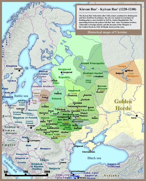
English: Historical map of Kievan Rus' and territory of Ukraine: last 20 years of the state (1220-1240), english version. |
| Date | |
| Source | Own work - Other example of similar map: http://izbornyk.org.ua/litop/map_1240.htm |
| Author | SeikoEn, overworked and reloaded by Ulamm (talk) 22:42, 30 April 2014 (UTC) |
| Other versions | File:001 Kievan Rus' Kyivan Rus' Ukraine map 1220 1240.jpg |
Licensing
I, the copyright holder of this work, hereby publish it under the following licenses:

|
Permission is granted to copy, distribute and/or modify this document under the terms of the GNU Free Documentation License, Version 1.2 or any later version published by the Free Software Foundation; with no Invariant Sections, no Front-Cover Texts, and no Back-Cover Texts. A copy of the license is included in the section entitled GNU Free Documentation License. |
| This file is licensed under the Creative Commons Attribution-Share Alike 3.0 Unported license. | ||
| ||
| This licensing tag was added to this file as part of the GFDL licensing update. |
You may select the license of your choice.
File history
Click on a date/time to view the file as it appeared at that time.
| Date/Time | Thumbnail | Dimensions | User | Comment | |
|---|---|---|---|---|---|
| current | 16:59, 30 November 2023 | | 2,301 × 2,856 (6.1 MB) | X3qt | Reverted to version as of 17:28, 18 July 2014 (UTC), Vilnius did not existed in period covered by the map, Duchy of Lithuania was a vassal to Grand Duchy of Rus' |
| 11:15, 27 December 2018 |  | 2,301 × 2,856 (7.41 MB) | Radom1967 | Lithuania wasnt part of Kievan Rus | |
| 17:28, 18 July 2014 |  | 2,301 × 2,856 (6.1 MB) | Kopiersperre | optipng | |
| 22:42, 30 April 2014 |  | 2,301 × 2,856 (6.99 MB) | Ulamm | == {{int:filedesc}} == {{Information |Description={{en|1=Historical map of Kievan Rus' and territory of Ukraine: last 20 years of the state (1220-1240), english version.}} |Source={{own}} - Other example of similar map: http://izbornyk.org.ua/litop/map... |
File usage
The following pages on the English Wikipedia use this file (pages on other projects are not listed):
Global file usage
The following other wikis use this file:
- Usage on ca.wikipedia.org
- Usage on cs.wikipedia.org
- Usage on cv.wikipedia.org
- Usage on el.wikipedia.org
- Usage on fa.wikipedia.org
- Usage on fr.wikipedia.org
- Usage on gl.wikipedia.org
- Usage on hu.wikipedia.org
- Usage on id.wikipedia.org
- Usage on lv.wikipedia.org
- Usage on my.wikipedia.org
- Usage on pnb.wikipedia.org
- Usage on pt.wikipedia.org
- Usage on sk.wikipedia.org
- Usage on sl.wikipedia.org
- Usage on ta.wikipedia.org
- Usage on tk.wikipedia.org
- Usage on tt.wikipedia.org
- Usage on ur.wikipedia.org