
File:Land.ops.2.en.svg

Size of this PNG preview of this SVG file: 800 × 581 pixels. Other resolutions: 320 × 233 pixels | 640 × 465 pixels | 1,024 × 744 pixels | 1,280 × 930 pixels | 2,560 × 1,860 pixels | 940 × 683 pixels.
Original file (SVG file, nominally 940 × 683 pixels, file size: 1.42 MB)
| This is a file from the Wikimedia Commons. Information from its description page there is shown below. Commons is a freely licensed media file repository. You can help. |

| Description |
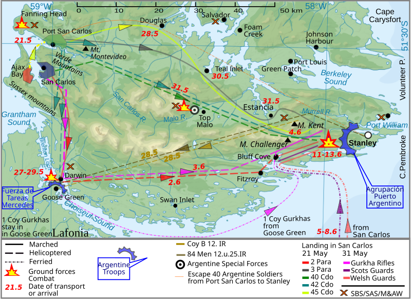
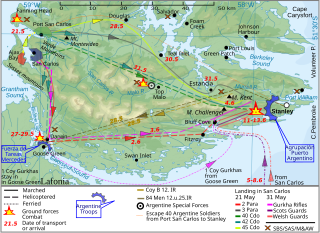
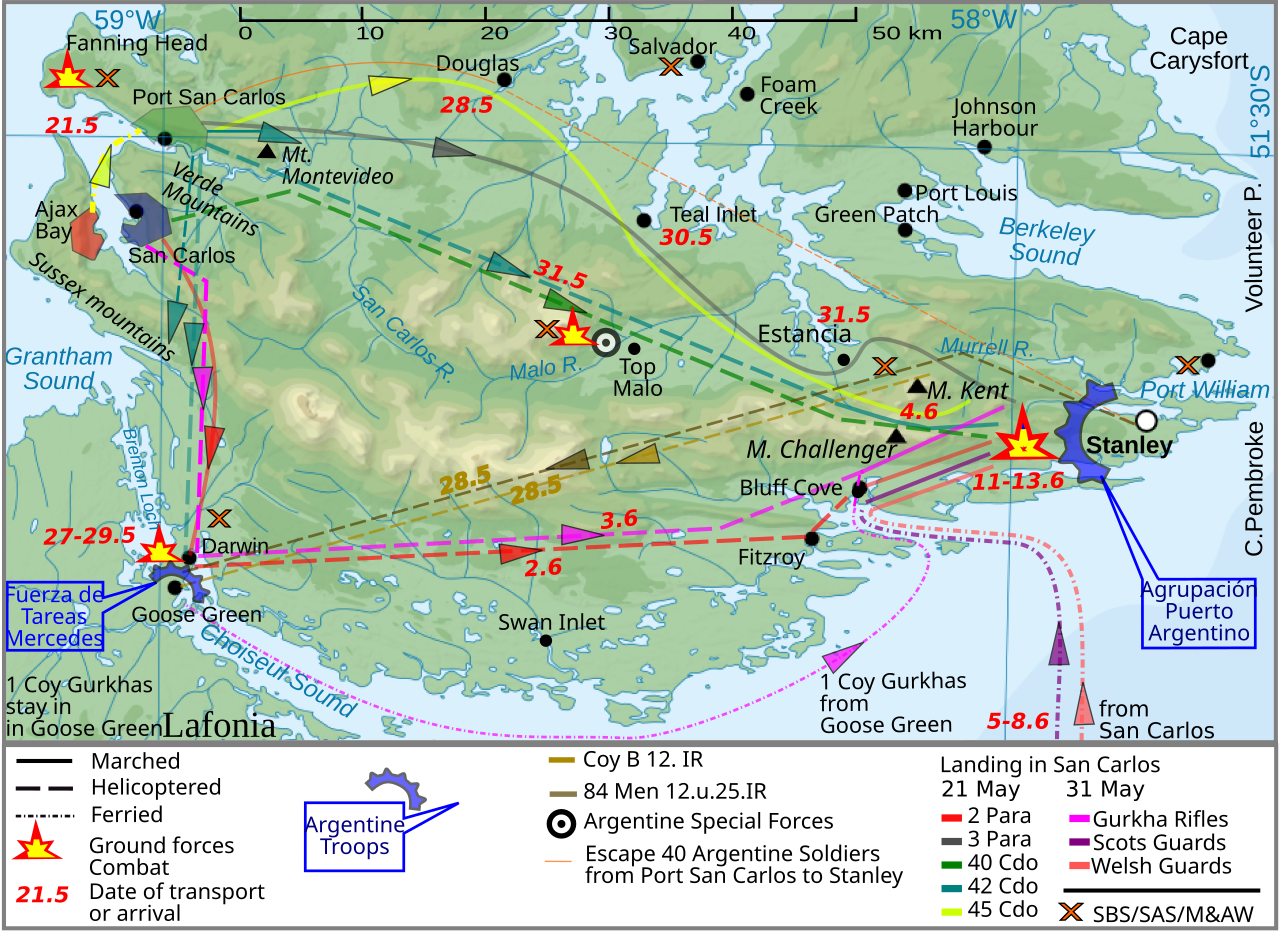
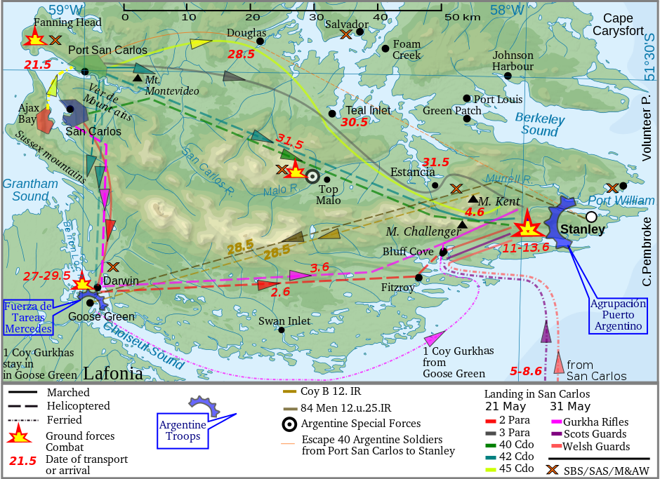
English: The Falkland Islands are an archipelago in the South Atlantic Ocean |
| Date | (UTC) |
| Source | |
| Author |
|
| This is a retouched picture, which means that it has been digitally altered from its original version. The original can be viewed here: Falkland Islands topographic map-en.svg:
|

|
Permission is granted to copy, distribute and/or modify this document under the terms of the GNU Free Documentation License, Version 1.2 or any later version published by the Free Software Foundation; with no Invariant Sections, no Front-Cover Texts, and no Back-Cover Texts. A copy of the license is included in the section entitled GNU Free Documentation License. |
This W3C-unspecified vector image was created with Inkscape .
Uploaded with derivativeFX
File history
Click on a date/time to view the file as it appeared at that time.
| Date/Time | Thumbnail | Dimensions | User | Comment | |
|---|---|---|---|---|---|
| current | 10:40, 26 March 2012 | | 940 × 683 (1.42 MB) | Brammers | Spelling change: Marsh > Marched |
| 19:47, 1 November 2010 |  | 940 × 683 (1.42 MB) | Keysanger | {{Information |Description={{en|The '''Falkland Islands''' are an archipelago in the South Atlantic Ocean}} |Source=*File:Falkland_Islands_topographic_map-en.svg |Date=2010-11-01 19:44 (UTC) |Author=*[[:File:Falkland_Islands_topographic_map-en.s |
File usage
The following pages on the English Wikipedia use this file (pages on other projects are not listed):
Global file usage
The following other wikis use this file:
- Usage on fy.wikipedia.org
- Usage on he.wikipedia.org
- Usage on lt.wikipedia.org
- Usage on pl.wikipedia.org
- Usage on ro.wikipedia.org
- Usage on ru.wikipedia.org
- Usage on zh.wikipedia.org