
File:Leeuwin current 2.jpg
No higher resolution available.
Leeuwin_current_2.jpg (250 × 425 pixels, file size: 30 KB, MIME type: image/jpeg)
| This is a file from the Wikimedia Commons. Information from its description page there is shown below. Commons is a freely licensed media file repository. You can help. |
Summary
| Description |
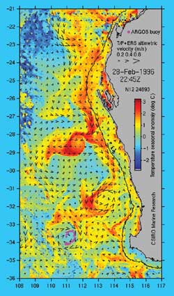
English: Satellite imagery from US NOAA 14 satellite while the surface current velocity is derived from sea level measurements made by the satellite-borne altimeter. Sea level data from the US/French Topex/Poseidon and European ERS altimeters are combined with coastal tide gauge data to make this velocity map. |
| Source | NOAA |
| Author | National Oceanic and Atmospheric Administration |
Licensing
This image is in the public domain because it contains materials that originally came from the U.S. National Oceanic and Atmospheric Administration, taken or made as part of an employee's official duties.
|
Original upload log
The original description page was here. All following user names refer to en.wikipedia.
- 2006-02-22 02:47 John D. Croft 250×425× (30219 bytes) Satellite imagery from US NOAA 14 satellite while the surface current velocity is derived from sea level measurements made by the satellite-borne altimeter. Sea level data from the US/French Topex/Poseidon and European ERS altimeters are combined with coa
File history
Click on a date/time to view the file as it appeared at that time.
| Date/Time | Thumbnail | Dimensions | User | Comment | |
|---|---|---|---|---|---|
| current | 13:21, 19 November 2012 | | 250 × 425 (30 KB) | Esprit Fugace | User created page with UploadWizard |
File usage
The following pages on the English Wikipedia use this file (pages on other projects are not listed):
Global file usage
The following other wikis use this file:
- Usage on ca.wikipedia.org
- Usage on fr.wikipedia.org
- Usage on is.wikipedia.org
- Usage on nl.wikipedia.org