
File:LocationMacedonia-MAC-3-z.png
No higher resolution available.
LocationMacedonia-MAC-3-z.png (500 × 400 pixels, file size: 12 KB, MIME type: image/png)
| This is a file from the Wikimedia Commons. Information from its description page there is shown below. Commons is a freely licensed media file repository. You can help. |
Summary
Licensing
| I, the copyright holder of this work, release this work into the public domain. This applies worldwide. In some countries this may not be legally possible; if so: I grant anyone the right to use this work for any purpose, without any conditions, unless such conditions are required by law. |
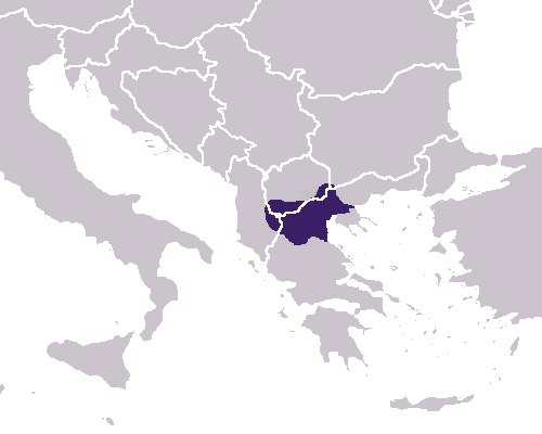
Map of Macedon before 359BC, taken from w:Britannica [1]
File history
Click on a date/time to view the file as it appeared at that time.
| Date/Time | Thumbnail | Dimensions | User | Comment | |
|---|---|---|---|---|---|
| current | 13:38, 25 August 2018 | | 500 × 400 (12 KB) | Jingiby | Per Britannica. |
| 10:13, 16 March 2008 |  | 500 × 400 (6 KB) | Dimboukas | Reverted to version as of :, 0 <> | |
| 16:45, 15 March 2008 |  | 500 × 400 (6 KB) | Polibiush | Please do not revert the correct map from Britannica | |
| 16:03, 15 March 2008 |  | 500 × 400 (6 KB) | Dimboukas | Reverted to version as of 09:31, 9 March 2008 | |
| 16:21, 9 March 2008 |  | 500 × 400 (6 KB) | Polibiush | Please do not revert the correct map from Britannica | |
| 09:31, 9 March 2008 |  | 500 × 400 (6 KB) | Dimboukas | Yes but it is very south. | |
| 17:18, 8 March 2008 |  | 500 × 400 (6 KB) | Polibiush | Part of Lake prespa is in Albania, the original map from Britannica is correct | |
| 09:03, 8 March 2008 |  | 500 × 400 (6 KB) | Dimboukas | Reverted to version as of 16:17, 7 March 2008 | |
| 17:06, 7 March 2008 |  | 500 × 400 (6 KB) | Polibiush | ||
| 16:17, 7 March 2008 |  | 500 × 400 (6 KB) | Dimboukas | The location of the ancient macedonian kingdom before the conquests of Philip II c. 350 BC. According to the Britannica Encyclopaedia the borders were: from west to east, the Lake Prespa until the Strymonas river. From north to south, from Kerkini lake u |
File usage
The following pages on the English Wikipedia use this file (pages on other projects are not listed):