
File:Lochailort, the Camerons' cairns - geograph.org.uk - 918058.jpg
Lochailort,_the_Camerons'_cairns_-_geograph.org.uk_-_918058.jpg (640 × 480 pixels, file size: 125 KB, MIME type: image/jpeg)
| This is a file from the Wikimedia Commons. Information from its description page there is shown below. Commons is a freely licensed media file repository. You can help. |
Summary
| Description |
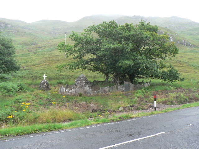
English: Lochailort: the Camerons' cairns These three cairns stand alongside the A830 and Loch Eilt. The largest, under the tree, has a plaque in front stating:
"This plaque was erected by the friends and servants of Duncan Cameron of Inverailort on the day of his funeral, 30th June 1874. They carried his coffin from Inverailort House to this point where his property begins on the north side of Loch Eilt and here it was placed in the hearse which conveyed his mortal remains to their rest in the family burying ground at Kilmallie. The oak trees round the cairn, the leaf of which is the Cameron badge, were planted on the same melancholy occasion. Requiescat in pace." The middle one has set within it a headstone, stating (my apologies if the Gaelic is not quite right or needs some capital letters): "Francis Cameron-Head of Inverailort, 17th November 1896 - 14th May 1957. This cairn is erected to his memory by his neighbours and friends. Mar chuimneachan air sar dhuine uasal aig an rob meas mor air ceol acus canain na gaidhealtachd" The third, with the white cross on its top, has a plaque stating: "Erected to the memory of Ronald MacLeod of Altdarroch, Kinlocheil, died 22nd June 1945, aged 82 years. For many years a valued friend and trusted employee of the Cameron-Head family. R.I.P." |
| Date | |
| Source | From geograph.org.uk |
| Author | Chris Downer |
| Attribution (required by the license) | Chris Downer / Lochailort: the Camerons’ cairns / |
| Camera location | | View this and other nearby images on: OpenStreetMap |
|---|
_heading:45.00&language=en)
| Object location | | View this and other nearby images on: OpenStreetMap |
|---|
_heading:45.00&language=en)
Licensing

|
This image was taken from the
Creative Commons Attribution-ShareAlike 2.0 license. |
- You are free:
- to share – to copy, distribute and transmit the work
- to remix – to adapt the work
- Under the following conditions:
- attribution – You must give appropriate credit, provide a link to the license, and indicate if changes were made. You may do so in any reasonable manner, but not in any way that suggests the licensor endorses you or your use.
- share alike – If you remix, transform, or build upon the material, you must distribute your contributions under the same or compatible license as the original.
File history
Click on a date/time to view the file as it appeared at that time.
| Date/Time | Thumbnail | Dimensions | User | Comment | |
|---|---|---|---|---|---|
| current | 23:19, 21 February 2011 | | 640 × 480 (125 KB) | GeographBot | == {{int:filedesc}} == {{Information |description={{en|1=Lochailort: the Camerons cairns These three cairns stand alongside the A830 and Loch Eilt. The largest, under the tree, has a plaque in front stating: This plaque was erected by the friends a |