
File:Map-of-Unified-Mongolia-1917.jpg

Original file (9,147 × 6,199 pixels, file size: 59.47 MB, MIME type: image/jpeg)
| This is a file from the Wikimedia Commons. Information from its description page there is shown below. Commons is a freely licensed media file repository. You can help. |
Summary
| Description |
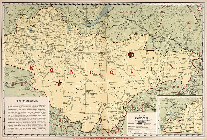
English: A detailed map of unified Mongolia in 1917. It includes Outer Mongolia with Inner Mongolia (Southern Mongolia) and the northwestern region of Tannu Uriankhai. These are historic regions of Mongolia. The map is based on dates of data (through 1916) and comments by the author in the preface.
Deutsch: Eine detaillierte englische Karte der vereinigten Mongolei im Jahr 1917. Sie umfasst die Äußere Mongolei mit der Inneren Mongolei (Südmongolei) und die nordwestliche Region Tannu Uriankhai. Dies sind historische Regionen der Mongolei. Die Karte basiert auf Datendaten (bis 1916) und Kommentaren des Autors im Vorwort.
Español: Un mapa inglés detallado de Mongolia unificada en 1917. Incluye Mongolia Exterior con Mongolia Interior (Mongolia Meridional) y la región noroeste de Tannu Uriankhai. Estas son regiones históricas de Mongolia. El mapa se basa en las fechas de los datos (hasta 1916) y los comentarios del autor en el prefacio.
Português: Um mapa inglês detalhado da Mongólia unificada em 1917. Inclui a Mongólia Externa com a Mongólia Interna (Mongólia Meridional) e a região noroeste de Tannu Uriankhai. Estas são regiões históricas da Mongólia. O mapa é baseado em datas de dados (até 1916) e comentários do autor no prefácio.
Français : Une carte anglaise détaillée de la Mongolie unifiée en 1917. Elle comprend la Mongolie extérieure avec la Mongolie intérieure (Mongolie méridionale) et la région nord-ouest de Tannu Uriankhai. Ce sont des régions historiques de la Mongolie. La carte est basée sur les dates des données (jusqu'en 1916) et les commentaires de l'auteur dans la préface.
Italiano: Una mappa inglese dettagliata della Mongolia unificata nel 1917. Include la Mongolia esterna con la Mongolia interna (Mongolia meridionale) e la regione nord-occidentale di Tannu Uriankhai. Queste sono regioni storiche della Mongolia. La mappa si basa sulle date dei dati (fino al 1916) e sui commenti dell'autore nella prefazione.
Русский: Подробная английская карта объединенной Монголии в 1917 году. Она включает Внешнюю Монголию с Внутренней Монголией (Южная Монголия) и северо-западный регион Танну Урианхай. Это исторические регионы Монголии. Карта основана на датах данных (до 1916 г.) и комментариях автора в предисловии.
Монгол: 1917 оны нэгдсэн Монгол улсын нарийвчилсан англи газрын зураг. Үүнд Өвөр Монгол (Өмнөд Монгол) болон Танну Урианхайн баруун хойд бүс нутаг бүхий Гадаад Монгол орно. Эдгээр нь Монголын түүхэн бүс нутаг юм. Газрын зураг нь өгөгдлийн огноо (1916 он хүртэл) болон өмнөх үгэнд бичсэн зохиогчийн тайлбар дээр үндэслэсэн болно.
日本語: 1917年に統一されたモンゴルの詳細な英語の地図。これには、外モンゴルと内モンゴル(南モンゴル)およびタンヌウリャンカイの北西部が含まれます。 これらはモンゴルの歴史的な地域です。 この地図は、データの日付(1916年まで)と序文の著者によるコメントに基づいています。
中文:1917 年统一蒙古的详细英文地图。它包括外蒙古与内蒙古(南蒙古)和塔努乌里安开西北地区。 这些是蒙古的历史地区。 该地图基于数据日期(到 1916 年)和作者在前言中的评论。 |
| Date | |
| Source | David Rumsey Map Collection https://www.davidrumsey.com/luna/servlet/detail/RUMSEY~8~1~288163~90059571:21--Mongolia- , publisher: North-China Daily News & Herald, Ltd. (in Shanghai) |
| Author | Far Eastern Geographical Establishment; Dingle, John Edwin. |
Licensing
This image is now in the public domain in China because its term of copyright has expired. According to copyright laws of the People's Republic of China (with legal jurisdiction in the mainland only, excluding Hong Kong and Macao), amended November 11, 2020, Works of legal persons or organizations without legal personality, or service works, or audiovisual works, enter the public domain 50 years after they were first published, or if unpublished 50 years from creation. For photography works of natural persons whose copyright protection period expires before June 1, 2021 belong to the public domain. All other works of natural persons enter the public domain 50 years after the death of the creator. Uruguay Round Agreements Act (URAA) if the work was under copyright in its country of origin on the date that the URAA took effect in that country. (For the People's Republic of China, the URAA took effect on January 1, 1996. For the Republic of China (ROC), the URAA took effect on January 1, 2002.[1] )To uploader: Please provide where the image was first published and who created it or held its copyright.
|
  |
File history
Click on a date/time to view the file as it appeared at that time.
| Date/Time | Thumbnail | Dimensions | User | Comment | |
|---|---|---|---|---|---|
| current | 07:27, 13 December 2021 | | 9,147 × 6,199 (59.47 MB) | Artanisen | Uploaded a work by Far Eastern Geographical Establishment; Dingle, John Edwin. Published in 1917 based on dates of data (through 1916) and comments by the author in the preface. from David Rumsey Map Collection https://www.davidrumsey.com/luna/servlet/detail/RUMSEY~8~1~288163~90059571:21--Mongolia- with UploadWizard |
File usage
Global file usage
The following other wikis use this file:
- Usage on ta.wikipedia.org