
File:Map at millstaetter see.svg

Size of this PNG preview of this SVG file: 800 × 453 pixels. Other resolutions: 320 × 181 pixels | 640 × 363 pixels | 1,024 × 580 pixels | 1,280 × 725 pixels | 2,560 × 1,451 pixels | 1,313 × 744 pixels.
Original file (SVG file, nominally 1,313 × 744 pixels, file size: 124 KB)
| This is a file from the Wikimedia Commons. Information from its description page there is shown below. Commons is a freely licensed media file repository. You can help. |
| Description |
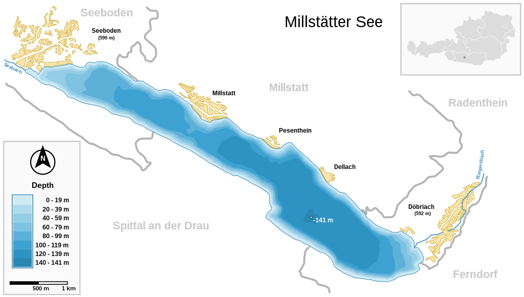
Deutsch: Millstätter See (Kärnten, Österreich) und wichtigste Ortschaften Seeboden / Millstatt / Pesenthein / Dellach / Döbriach
English: Millstätter See (Carinthia, Austria) with surrounding towns.
Français : Carte du lac Millstätter (Carinthie, Autriche) et des villes qui l'entourent. |
| Date | |
| Source | |
| Author | Michael Glanznig (Mglanznig) |
| Permission (Reusing this file) |
Creative Commons Attribution ShareAlike 2.0 Austria |
| Other versions | png |
| SVG development | This map is translated using SVG switch elements: all translations are stored in the same file. |
| Camera location | | View this and other nearby images on: OpenStreetMap |
|---|
|

This image was selected as
Austria ) with surrounding towns. |
I, the copyright holder of this work, hereby publish it under the following license:
This file is licensed under the Creative Commons Attribution-Share Alike 2.0 Austria license.
- You are free:
- to share – to copy, distribute and transmit the work
- to remix – to adapt the work
- Under the following conditions:
- attribution – You must give appropriate credit, provide a link to the license, and indicate if changes were made. You may do so in any reasonable manner, but not in any way that suggests the licensor endorses you or your use.
- share alike – If you remix, transform, or build upon the material, you must distribute your contributions under the same or compatible license as the original.

File history
Click on a date/time to view the file as it appeared at that time.
| Date/Time | Thumbnail | Dimensions | User | Comment | |
|---|---|---|---|---|---|
| current | 10:04, 27 March 2021 | | 1,313 × 744 (124 KB) | JoKalliauer | 1) width="1050pt" height="210mm" undefined behaviour (90 or 96 dpi) ; 2)<sodipodi:namedview pagecolor="#ffffff" replaced with <circle r="1e4" fill="#ffffff"/> and <rect width="100%" height="100%" fill="#ffffff"/>; 3) fonts replaced by fallback-fonts |
| 18:47, 10 June 2019 |  | 1,313 × 744 (239 KB) | Djiboun | File uploaded using svgtranslate tool (http://tools.wmflabs.org/svgtranslate/). Added translation for fr. | |
| 10:01, 16 April 2006 |  | 1,313 × 744 (238 KB) | Mglanznig | names for creeks | |
| 07:50, 15 April 2006 |  | 1,313 × 744 (236 KB) | Mglanznig | refinements | |
| 21:06, 13 April 2006 |  | 1,313 × 744 (233 KB) | Mglanznig | more svg rendering errors, praise Inkscape | |
| 20:43, 13 April 2006 |  | 1,313 × 744 (237 KB) | Mglanznig | svg errors corrected | |
| 20:35, 13 April 2006 |  | 1,313 × 744 (236 KB) | Mglanznig | ;Description : {{de|Millstätter See und wichtigste Ortschaften, Kärnten, Österreich}} {{en|Millstätter See with main towns, Carinthia, Austria}} ;Source : {{de|selbst zusammengestellt; Geodaten von [http://www.map24.com Map24] und [http://www.kagis.kt |
File usage
The following pages on the English Wikipedia use this file (pages on other projects are not listed):
Global file usage
The following other wikis use this file:
- Usage on arz.wikipedia.org
- Usage on be.wikipedia.org
- Usage on ceb.wikipedia.org
- Usage on de.wikipedia.org
- Usage on el.wikipedia.org
- Usage on eo.wikipedia.org
- Usage on fr.wikipedia.org
- Usage on hu.wikipedia.org
- Usage on hy.wikipedia.org
- Usage on ia.wikipedia.org
- Usage on id.wikipedia.org
- Usage on ko.wikipedia.org
- Usage on lv.wikipedia.org
- Usage on nl.wikipedia.org
- Usage on nl.wikibooks.org
- Usage on nn.wikipedia.org
- Usage on pl.wikipedia.org
- Usage on pt.wikipedia.org
- Usage on ru.wikipedia.org
- Usage on ru.wikinews.org
- Usage on su.wikipedia.org
- Usage on uk.wikipedia.org
- Usage on www.wikidata.org