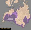
File:Map of Maguindanao 1521.png

Size of this preview: 626 × 600 pixels. Other resolutions: 251 × 240 pixels | 501 × 480 pixels | 802 × 768 pixels | 1,069 × 1,024 pixels | 2,138 × 2,048 pixels | 3,830 × 3,669 pixels.
Original file (3,830 × 3,669 pixels, file size: 396 KB, MIME type: image/png)
File history
Click on a date/time to view the file as it appeared at that time.
| Date/Time | Thumbnail | Dimensions | User | Comment | |
|---|---|---|---|---|---|
| current | 13:37, 5 October 2023 |  | 3,830 × 3,669 (396 KB) | Delirium333 | messed up tubok, had to fix |
| 13:27, 5 October 2023 |  | 3,830 × 3,669 (396 KB) | Delirium333 | more detailed interpretation of lanao | |
| 04:33, 2 October 2023 |  | 3,830 × 3,669 (394 KB) | Delirium333 | fixed the settlements inside modern-day cotabato city, because i screwed up the exact locations | |
| 01:26, 2 October 2023 |  | 3,830 × 3,669 (392 KB) | Delirium333 | my mistake regarding the removal of the subanen because according to STUDIES IN MORO HISTORY, LAW AND RELIGION by najeeb m saleeby that sharif kabungsuwan already influenced the subanen chiefs to pay tribute to his realm | |
| 10:46, 1 October 2023 |  | 3,830 × 3,669 (385 KB) | Delirium333 | another settlement added in between polloc and parang-parang | |
| 10:08, 1 October 2023 |  | 3,830 × 3,669 (385 KB) | Delirium333 | the capital was actually at tubok by 1521 so that had to be changed | |
| 22:37, 30 September 2023 |  | 3,830 × 3,669 (385 KB) | Delirium333 | urgent change: zamboanga datus were not under maguidanao in 1521, also lamitan was not in basilan but a place called ramitan in lanao del sur, as well as the adding of more polities in areas that maguindanao did control by 1521 | |
| 12:01, 29 September 2023 |  | 3,830 × 3,669 (390 KB) | Delirium333 | cosmetic changes | |
| 14:08, 27 September 2023 |  | 3,830 × 3,669 (390 KB) | Delirium333 | addition of kalagan chiefdoms in davao gulf and davao oriental | |
| 21:22, 26 September 2023 |  | 3,830 × 3,669 (389 KB) | Delirium333 | davao gulf coast edit |
File usage
The following pages on the English Wikipedia use this file (pages on other projects are not listed):
Global file usage
The following other wikis use this file:
- Usage on bcl.wikipedia.org
- Usage on es.wikipedia.org
- Usage on ja.wikipedia.org
- Usage on ko.wikipedia.org
- Usage on tl.wikipedia.org
- Usage on tr.wikipedia.org
- Usage on www.wikidata.org
