
File:Map of Operation Bertram.jpg
Size of this preview: 800 × 587 pixels. Other resolutions: 320 × 235 pixels | 640 × 469 pixels | 1,024 × 751 pixels | 1,171 × 859 pixels.
Original file (1,171 × 859 pixels, file size: 166 KB, MIME type: image/jpeg)
| This is a file from the Wikimedia Commons. Information from its description page there is shown below. Commons is a freely licensed media file repository. You can help. |
Summary
| Description |
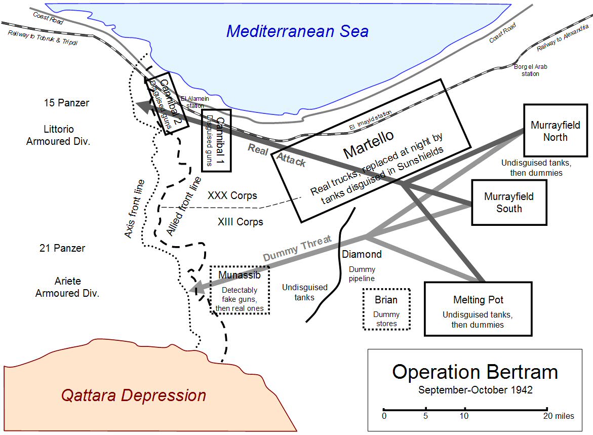
English: Map of Operation Bertram, the military deception for the en:Second Battle of El Alamein, 1942 |
| Date | |
| Source | Own work |
| Author | Chiswick Chap |
| Camera location | | View this and other nearby images on: OpenStreetMap |
|---|
Redrawn by hand based on map in The Camouflage Story, Geoffrey Barkas, Cassell, 1952.
Licensing
I, the copyright holder of this work, hereby publish it under the following license:
This file is licensed under the Creative Commons Attribution-Share Alike 3.0 Unported license.
- You are free:
- to share – to copy, distribute and transmit the work
- to remix – to adapt the work
- Under the following conditions:
- attribution – You must give appropriate credit, provide a link to the license, and indicate if changes were made. You may do so in any reasonable manner, but not in any way that suggests the licensor endorses you or your use.
- share alike – If you remix, transform, or build upon the material, you must distribute your contributions under the same or compatible license as the original.
File history
Click on a date/time to view the file as it appeared at that time.
| Date/Time | Thumbnail | Dimensions | User | Comment | |
|---|---|---|---|---|---|
| current | 14:04, 7 November 2012 | | 1,171 × 859 (166 KB) | Chiswick Chap | User created page with UploadWizard |
File usage
The following pages on the English Wikipedia use this file (pages on other projects are not listed):
Global file usage
The following other wikis use this file:
- Usage on id.wikipedia.org
- Usage on uk.wikipedia.org