
File:Map of USA with state names gl.svg

Size of this PNG preview of this SVG file: 800 × 495 pixels. Other resolutions: 320 × 198 pixels | 640 × 396 pixels | 1,024 × 633 pixels | 1,280 × 791 pixels | 2,560 × 1,583 pixels | 959 × 593 pixels.
Original file (SVG file, nominally 959 × 593 pixels, file size: 332 KB)
| This is a file from the Wikimedia Commons. Information from its description page there is shown below. Commons is a freely licensed media file repository. You can help. |
| Description |
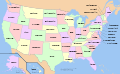
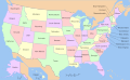
English: Map of USA with state names gl. |
| Date | 30 March 2008 (original upload date) |
| Source | No machine-readable source provided. Own work assumed (based on copyright claims). |
| Author | No machine-readable author provided. Furado assumed (based on copyright claims). |
== Summary ==
Galego
Mapa dos gl:Estados Unidos cos nombres dos estados en galego. Esta imaxe deriva da imaxe Image:Map of USA with state names.svg e os nomes dos estados foron traducidos por User:Furado. Esta tradución é para utilizar no gl:Modelo:Mapa dos estados dos Estados Unidos.
English
This is a map of the w:United States with the w:U.S. state names in galician language. This is a derivative work of Image:Map of USA with state names.svg, translated by User:Furado, to use in gl:Modelo:Mapa dos estados dos Estados Unidos.
Versions
Clickable

Licensing
I, the copyright holder of this work, hereby publish it under the following licenses:

|
Permission is granted to copy, distribute and/or modify this document under the terms of the GNU Free Documentation License, Version 1.2 or any later version published by the Free Software Foundation; with no Invariant Sections, no Front-Cover Texts, and no Back-Cover Texts. A copy of the license is included in the section entitled GNU Free Documentation License. |
This file is licensed under the Creative Commons Attribution-Share Alike Attribution-Share Alike 4.0 International, 3.0 Unported, 2.5 Generic, 2.0 Generic and 1.0 Generic license.
- You are free:
- to share – to copy, distribute and transmit the work
- to remix – to adapt the work
- Under the following conditions:
- attribution – You must give appropriate credit, provide a link to the license, and indicate if changes were made. You may do so in any reasonable manner, but not in any way that suggests the licensor endorses you or your use.
- share alike – If you remix, transform, or build upon the material, you must distribute your contributions under the same or compatible license as the original.
You may select the license of your choice.
[]
Multilingual:
 |
 |
 |
 |
 |
 |
 |
 |
 |
 |
 |
 |
 |
 |
 |
 |
 |
 |
 |
 |
 |
 |
 |
 |
 |
 |
 |
 |
 |
 |
 |
 |
 |
 |
 |
 |
 |
 |
 |
 |
 |
 |
 |
 |
 |
 |
 |
 |
 |
 |
 |
 |
 |
 |
 |
 |
 |
 |
 |
 |
 |
 |
 |
 |
 |
 |
 |
 |
 |
 |
 |
 |
 |
 |
 |
 |
 |
 |
 |
 |
 |
 |
 |
 |
 |
 |
 |
 |
 |
 |
 |
 |
 |
 |
 |
 |
 |
 |
 |
 |
 |
 |
 |
 |
 |
 |
 |
 |
 |
 |
 |
 |
 |
 |
 |
 |
 |
 |
 |
 |
 |
 |
 |
 |
 |
 |
 |
 |
 |
 |
 |
 |
 |
 |
 |
 |
 |
 |
 |
 |
 |
 |
 |
 |
 |
 |
 |
 |
 |
 |
 |
Other files:
-
 American sign language
 -
 anarâškielâ
 -
 bosanski
 -
 Diné bizaad
 -
 eesti
eesti -
 English (and mulilingual)
 -
 English
 -
 español
 -
 Esperanto
 -
 euskara
 -
 français
 -
 galego
 -
 Hawaiʻi
 -
 hrvatski
 -
 italiano
 -
 magyar
 -
 occitan PNG
 -
 polski
 -
 português
 -
 română
 -
 Scots
Scots -
 slovenčina
 -
 suomi
suomi -
 svenska
 -
 ślůnski
 -
 Ἀρχαία ἑλληνικὴ
 -
 Ελληνικά
 -
 български
 -
 македонски
 -
 нохчийн
 -
 русский
 -
 русский 2
 -
 српски (ћирилица)
 -
 українська
 -
 ქართული PNG
 -
 қазақша
 -
 मराठी
मराठी -
 हिन्दी
 -
 অসমীয়া
 -
 বাংলা
বাংলা -
 বিষ্ণুপ্রিয়া মণিপুরী
 -
 ਪੰਜਾਬੀ
 -
 മലയാളം
 -
 ไทย
ไทย -
 ᏣᎳᎩ
ᏣᎳᎩ -
 中文(简体)
 -
 中文(繁體)
 -
 עברית
עברית -
 اردو
اردو -
 العربية
 -
 فارسی
فارسی -
 فارسی JPG


.svg)


File history
Click on a date/time to view the file as it appeared at that time.
| Date/Time | Thumbnail | Dimensions | User | Comment | |
|---|---|---|---|---|---|
| current | 21:48, 3 July 2013 | | 959 × 593 (332 KB) | JaviP96 | Minor correction. |
| 16:38, 30 March 2008 |  | 959 × 593 (332 KB) | Furado | == Summary == ===Galego=== Mapa dos gl:Estados Unidos cos nombres dos estados en galego. Esta imaxe deriva da imaxe Image:Map of USA with state names.svg e os nomes dos estados foron traducidos por User:Furado. Esta tradución é para utili |
File usage
No pages on the English Wikipedia use this file (pages on other projects are not listed).
Global file usage
The following other wikis use this file: