
File:Map of the route of Edward III's chevauchée of 1346.svg

Size of this PNG preview of this SVG file: 643 × 600 pixels. Other resolutions: 257 × 240 pixels | 515 × 480 pixels | 823 × 768 pixels | 1,098 × 1,024 pixels | 2,195 × 2,048 pixels | 1,059 × 988 pixels.
Original file (SVG file, nominally 1,059 × 988 pixels, file size: 450 KB)
| This is a file from the Wikimedia Commons. Information from its description page there is shown below. Commons is a freely licensed media file repository. You can help. |
Summary
| Description |
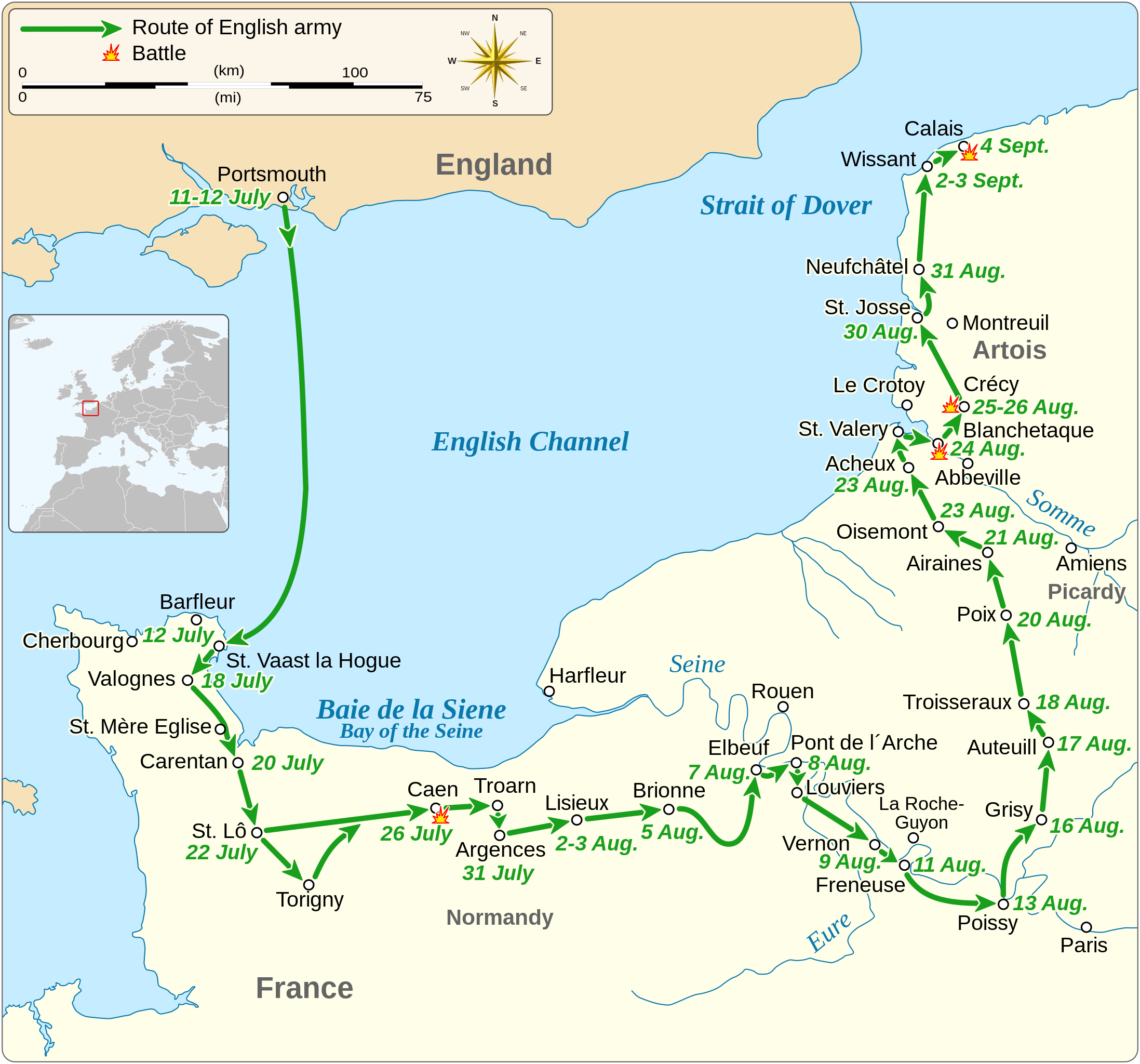
English: Map of the route of Edward III's chevauchée of 1346, part of the Hundred Years' War. This map shows the English army movements during the campaign and the most important battles.
|
||||||||||||||||||||||||||||||||||||||||||||||||
| Date | |||||||||||||||||||||||||||||||||||||||||||||||||
| Source |
Own work Derived from; Information from:
|
||||||||||||||||||||||||||||||||||||||||||||||||
| Author | Goran tek-en | ||||||||||||||||||||||||||||||||||||||||||||||||
| Permission (Reusing this file) |
This file is licensed under the Creative Commons Attribution-Share Alike 4.0 International license. Attribution: Goran tek-en
|
||||||||||||||||||||||||||||||||||||||||||||||||
| SVG development | This vector image was created with Inkscape. |
||||||||||||||||||||||||||||||||||||||||||||||||


| Object location | | View this and other nearby images on: OpenStreetMap |
|---|


File history
Click on a date/time to view the file as it appeared at that time.
| Date/Time | Thumbnail | Dimensions | User | Comment | |
|---|---|---|---|---|---|
| current | 00:14, 3 February 2022 | | 1,059 × 988 (450 KB) | Iso10970 | Reverted to version as of 13:17, 9 November 2021 (UTC) |
| 00:13, 3 February 2022 |  | 1,059 × 988 (614 KB) | Iso10970 | File uploaded using svgtranslate tool (https://svgtranslate.toolforge.org/). Added translation for ja. | |
| 13:17, 9 November 2021 |  | 1,059 × 988 (450 KB) | Goran tek-en | Changed view box, font size, added location map | |
| 13:06, 14 April 2019 |  | 1,059 × 988 (191 KB) | Goran tek-en | Spelling | |
| 17:53, 10 March 2019 |  | 1,059 × 988 (115 KB) | JoKalliauer | phab:T36947 bad character aligment on same sizes | |
| 14:08, 6 March 2019 |  | 1,059 × 988 (191 KB) | Goran tek-en | {{Information |description ={{en|1=Map of the route of Edward III's chevauchée of 1346, part of the Hundred Years' War. This map shows the English army movements during the campaign and the most important battles.}} |date =20190306 |source ={{Own}}<br> Derived from; * [https://www.openstreetmap.org/#map=8/49.919/1.371 OSM] Information from: * [https://www.themaparchive.com/the-crecy-campaign-12-july-to-4-september-1346.html themaparchive.com] * {{U|Newm30}} |author... |
File usage
The following pages on the English Wikipedia use this file (pages on other projects are not listed):
Global file usage
The following other wikis use this file:
- Usage on cs.wikipedia.org
- Usage on es.wikipedia.org
- Usage on fi.wikipedia.org
- Usage on fr.wikipedia.org
- Usage on hu.wikipedia.org
- Usage on ja.wikipedia.org
- Usage on nl.wikipedia.org
- Usage on pt.wikipedia.org
- Usage on ru.wikipedia.org
- Usage on sh.wikipedia.org
- Usage on tr.wikipedia.org
- Usage on zh.wikipedia.org