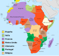
File:Mapa del África colonial (1914).svg

Page contents not supported in other languages.
This is a file from the Wikimedia Commons
Source: Wikipedia, the free encyclopedia.

Original file(SVG file, nominally 1,525 × 1,440 pixels, file size: 859 KB)

Summary

Description
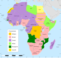
Español: Mapa del África colonial en el 1914, en español.
Deutsch: Karte des kolonialen Afrika im Jahr 1914, auf Spanisch.
Italiano: Mappa dell'Africa coloniale nel 1914, in spagnolo.
Date
Source Own work
Author Milenioscuro
Permission
(Reusing this file)

This file was derived from:

Other versions

[edit]


1800
  • English
    English
1870
  • English
    English
1900
  • English
    English
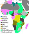
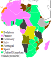
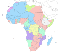
between 1912 and 1914
date QS:P,+1912-00-00T00:00:00Z/8,P1319,+1912-00-00T00:00:00Z/9,P1326,+1914-00-00T00:00:00Z/9
  • español
    español
  • Deutsch
    Deutsch
  • asturianu
    asturianu
  • 閩南語 / Bân-lâm-gú
    閩南語 / Bân-lâm-gú
  • čeština
    čeština
  • dansk
    dansk
  • Deutsch
    Deutsch
  • Deutsch
    Deutsch
  • Deutsch
    Deutsch
  • English
    English
  • English
    English
  • English
    English
  • English
    English
  • English
    English
  • English
    English
  • español
    español
  • español
    español
  • español
    español
  • español
    español
  • euskara
    euskara
  • euskara
    euskara
  • føroyskt
    føroyskt
  • Kiswahili
    Kiswahili
  • norsk
    norsk
  • polski
    polski
  • polski
    polski
  • svenska
    svenska
  • български
    български
  • српски (ћирилица)
    српски (ћирилица)
  • српски (ћирилица)
    српски (ћирилица)
  • Ελληνικά
    Ελληνικά
  • 中文
    中文
  • 中文
    中文
1923
  • English
    English
1935
  • English
    English
1939
  • español
    español
  • English
    English
1947
  • español
    español
  • polski
    polski
SVG development
InfoField
 
The source code of this SVG is invalid due to 56 errors.
 
This W3C-invalid map was created with Inkscape.
 
 This map uses embedded text that can be easily translated using a text editor.
 
The file size of this SVG map may be irrationally large because its text has been converted to paths inhibiting translations.

Licensing

I, the copyright holder of this work, hereby publish it under the following license:
w:en:Creative Commons
attribution share alike
This file is licensed under the Creative Commons Attribution-Share Alike 4.0 International license.
You are free:
  • to share – to copy, distribute and transmit the work
  • to remix – to adapt the work
Under the following conditions:
  • attribution – You must give appropriate credit, provide a link to the license, and indicate if changes were made. You may do so in any reasonable manner, but not in any way that suggests the licensor endorses you or your use.
  • share alike – If you remix, transform, or build upon the material, you must distribute your contributions under the same or compatible license as the original.

Captions

Map of colonial Africa in 1914, in Spanish.

Items portrayed in this file

depicts

9 April 2019

image/svg+xml

File history

Click on a date/time to view the file as it appeared at that time.

Date/TimeThumbnailDimensionsUserComment
current19:10, 19 March 2020Thumbnail for version as of 19:10, 19 March 20201,525 × 1,440 (859 KB)RowanwindwhistlerFake text added for better rendering in articles.
15:41, 9 April 2019Thumbnail for version as of 15:41, 9 April 20191,525 × 1,440 (839 KB)MilenioscuroUser created page with UploadWizard
No pages on the English Wikipedia use this file (pages on other projects are not listed).

Global file usage

Metadata