
Search results
There is a page named "File:Mayo Barony-Map Erris.jpg" on Wikipedia
 DescriptionMayo Barony-Map Erris.jpg Barony Map of Mayo with Erris Highlighted Date 19 August 2010 Source Own work Author Jacobfrid Permission (Reusing...(843 × 740 (77 KB)) - 14:31, 26 September 2020
 DescriptionBarony of Erris - Louth Compare.jpg English: A size comparison between Erris (857 km2) and County Louth (820 km2). Date 23 August 2010 Source...(1,501 × 789 (35 KB)) - 00:55, 1 November 2023
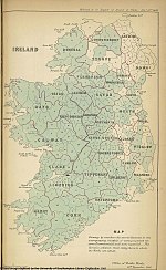 DescriptionBaronies of Ireland 1846.jpg English: Map of Ireland in 1846 showing county and barony boundaries. It was printed in one of the official reports...(1,200 × 1,952 (452 KB)) - 00:38, 1 November 2023


