
File:Mongols-map.png
Size of this preview: 722 × 599 pixels. Other resolutions: 289 × 240 pixels | 578 × 480 pixels | 925 × 768 pixels | 1,234 × 1,024 pixels | 1,801 × 1,495 pixels.
Original file (1,801 × 1,495 pixels, file size: 2.79 MB, MIME type: image/png)
| This is a file from the Wikimedia Commons. Information from its description page there is shown below. Commons is a freely licensed media file repository. You can help. |
Summary
| Description |
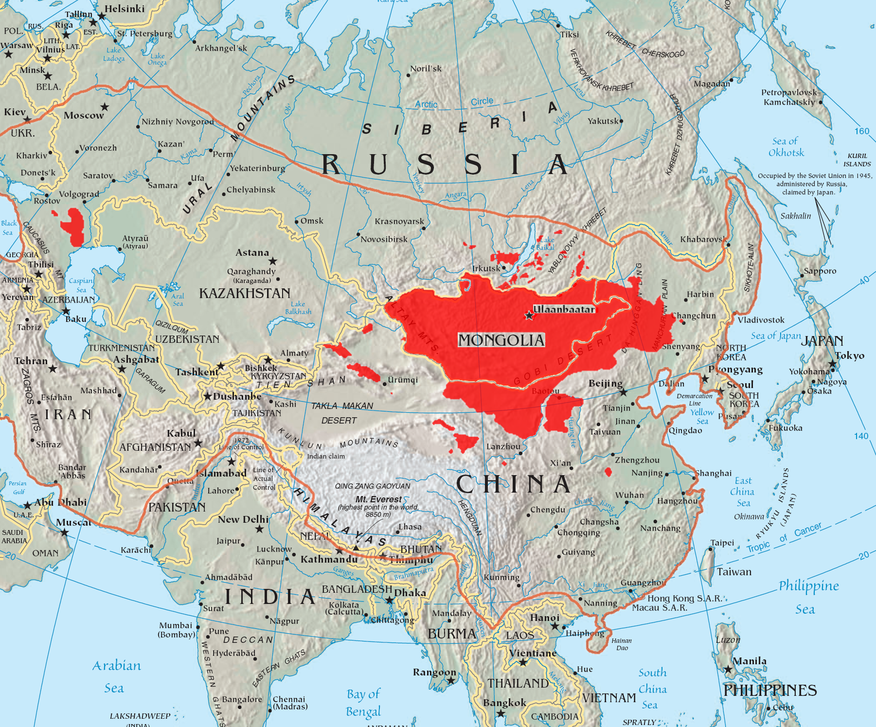
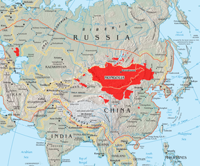
English: A map of the places that Mongol peoples live.
The orange line shows the extent of the Mongol Empire in the late 13th century. The red areas are the places dominated by ethnic Mongols. |
| Date | |
| Source |
|
| Author | Quadell |

|
This linguistic map image could be re-created using vector graphics as an SVG file. This has several advantages; see Commons:Media for cleanup for more information. If an SVG form of this image is available, please upload it and afterwards replace this template with
{{vector version available|new image name}}.
It is recommended to name the SVG file “Mongols-map.svg”—then the template Vva ) does not need the new image name parameter. |
Licensing
I, the copyright holder of this work, hereby publish it under the following licenses:

|
Permission is granted to copy, distribute and/or modify this document under the terms of the GNU Free Documentation License, Version 1.2 or any later version published by the Free Software Foundation; with no Invariant Sections, no Front-Cover Texts, and no Back-Cover Texts. A copy of the license is included in the section entitled GNU Free Documentation License. |
| This file is licensed under the Creative Commons Attribution-Share Alike 3.0 Unported license. | ||
| ||
| This licensing tag was added to this file as part of the GFDL licensing update. |
This file is licensed under the Creative Commons Attribution-Share Alike 2.0 Generic license.
- You are free:
- to share – to copy, distribute and transmit the work
- to remix – to adapt the work
- Under the following conditions:
- attribution – You must give appropriate credit, provide a link to the license, and indicate if changes were made. You may do so in any reasonable manner, but not in any way that suggests the licensor endorses you or your use.
- share alike – If you remix, transform, or build upon the material, you must distribute your contributions under the same or compatible license as the original.
You may select the license of your choice.
File history
Click on a date/time to view the file as it appeared at that time.
| Date/Time | Thumbnail | Dimensions | User | Comment | |
|---|---|---|---|---|---|
| current | 14:37, 29 May 2023 | | 1,801 × 1,495 (2.79 MB) | Artanisen | High resolution map with the same borders and areas as version 17:34, 16 July 2005 (UTC) |
| 20:13, 10 April 2021 |  | 728 × 525 (279 KB) | Fæ | Reverted to version as of 17:34, 16 July 2005 (UTC) Untrusted work of sockpuppets | |
| 03:35, 17 January 2019 |  | 728 × 525 (295 KB) | Anchuhu | mongol | |
| 10:56, 22 June 2017 |  | 728 × 525 (630 KB) | 일성강 | Reverted to version as of 12:47, 1 June 2017 (UTC) | |
| 08:54, 17 June 2017 |  | 728 × 525 (279 KB) | Calthinus | Reverted to version as of 17:34, 16 July 2005 (UTC) | |
| 12:47, 1 June 2017 |  | 728 × 525 (630 KB) | 일성강 | fixed | |
| 17:34, 16 July 2005 |  | 728 × 525 (279 KB) | Hottentot~commonswiki | This is a map of the places that Mongol peoples live. The information is based off of w:en:Image:Mongolsethnic.jpg, and the map I started with is w:en:Image:Asia-map.png. The orange line shows the extent of the Mongol Empire in the late 13th c | |
| 13:14, 16 July 2005 |  | 728 × 525 (297 KB) | Quadell | This is a map of the places that Mongol peoples live. The information is based off of [:w:en:Image:Mongolsethnic.jpg]], and the map I started with is w:en:Image:Asia-map.png. The orange line shows the extent of the Mongol Empire in the late 13th ce |
File usage
More than 100 pages use this file. The following list shows the first 100 pages that use this file only. A full list is available.
- Kalmyks
- Mongol Empire
- Mongolia
- Mongols
- Talk:Almas (folklore)
- Talk:Altai Mountains
- Talk:Asashōryū Akinori
- Talk:Ayurbarwada Buyantu Khan
- Talk:Baghdad Khatun
- Talk:Battle of Ain Jalut
- Talk:Battle of Baideng
- Talk:Battle of Kulikovo
- Talk:Battle of Kōan
- Talk:Battle of Legnica
- Talk:Battle of Parwan
- Talk:Battle of Yamen
- Talk:Battles of Khalkhin Gol
- Talk:Batu Khan
- Talk:Bayan-Ölgii Province
- Talk:Biligtü Khan Ayushiridara
- Talk:Bonan people
- Talk:Buyant-Ukhaa International Airport
- Talk:Chagatai Khan
- Talk:Chagatai Khanate
- Talk:Choghtu Khong Tayiji
- Talk:Culture of Mongolia
- Talk:Daur people
- Talk:Demchugdongrub
- Talk:Elections in Mongolia
- Talk:Foreign relations of Mongolia
- Talk:Gegeen Khan
- Talk:Giovanni da Pian del Carpine
- Talk:Gobi Desert
- Talk:Golden Horde
- Talk:Göktürks
- Talk:Güyük Khan
- Talk:Han-Zhao
- Talk:History of Mongolia
- Talk:History of modern Mongolia
- Talk:Hong Bok-won
- Talk:Inner Mongolian People's Party
- Talk:Jayaatu Khan Tugh Temür
- Talk:Jebe
- Talk:Jebtsundamba Khutuktu
- Talk:Jin dynasty (1115–1234)
- Talk:Khalkha Mongols
- Talk:Khan (title)
- Talk:Khanbaliq
- Talk:Khorloogiin Choibalsan
- Talk:Khutughtu Khan Kusala
- Talk:Kublai Khan
- Talk:Mausoleum of Genghis Khan
- Talk:Merkit
- Talk:Mongol Empire
- Talk:Mongol Rally
- Talk:Mongol invasion of Europe
- Talk:Mongol invasion of Kievan Rus'
- Talk:Mongol invasions of Japan
- Talk:Mongolian death worm
- Talk:Mongolian writing systems
- Talk:Monguor people
- Talk:Morin khuur
- Talk:Music in the Tuva Republic
- Talk:Music of Buryatia
- Talk:Music of Mongolia
- Talk:Naadam
- Talk:Nambaryn Enkhbayar
- Talk:Old Turkic script
- Talk:Orkhon inscriptions
- Talk:Outer Mongolia
- Talk:Overtone singing
- Talk:Pacific War
- Talk:Pax Mongolica
- Talk:Proto-Mongols
- Talk:Provinces of Mongolia
- Talk:Przewalski's horse
- Talk:Qara Khitai
- Talk:Ragibagh Khan
- Talk:Rinchinbal Khan
- Talk:Roman von Ungern-Sternberg
- Talk:Rouran Khaganate
- Talk:Secret History of the Mongols
- Talk:Song dynasty
- Talk:Tartary
- Talk:Tatars
- Talk:The Conqueror (1956 film)
- Talk:The Travels of Marco Polo
- Talk:Tibetan Buddhism
- Talk:Timeline of Mongolian history
- Talk:Toghon Temür
- Talk:Treaty of friendship and alliance between the Government of Mongolia and Tibet
- Talk:Tumen (unit)
- Talk:Tumu Crisis
- Talk:Tuva
- Talk:Tuvans
- Talk:Western Xia
- Talk:Xiongnu
- Talk:Yassa
- Talk:Yesün Temür (Yuan dynasty)
- Talk:Ögedei Khan
View more links to this file.
Global file usage
The following other wikis use this file:
- Usage on af.wikipedia.org
- Usage on an.wikipedia.org
- Usage on ar.wikipedia.org
- Usage on arz.wikipedia.org
- Usage on ast.wikipedia.org
- Usage on azb.wikipedia.org
- Usage on ba.wikipedia.org
- Usage on be-tarask.wikipedia.org
- Usage on be.wikipedia.org
- Usage on bg.wiktionary.org
- Usage on bh.wikipedia.org
- Usage on br.wikipedia.org
- Usage on bs.wikipedia.org
- Usage on ca.wikipedia.org
- Usage on ckb.wikipedia.org
- Usage on cs.wikipedia.org
- Usage on cv.wikipedia.org
- Usage on da.wikipedia.org
- Usage on diq.wikipedia.org
- Usage on dsb.wikipedia.org
- Usage on el.wikipedia.org
- Usage on en.wikivoyage.org
- Usage on eo.wikipedia.org
- Usage on es.wikipedia.org
- Usage on et.wikipedia.org
View more global usage of this file.