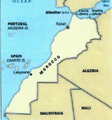
File:Morocco-CIA WFB Map.png
Morocco-CIA_WFB_Map.png (329 × 353 pixels, file size: 17 KB, MIME type: image/png)
File history
Click on a date/time to view the file as it appeared at that time.
| Date/Time | Thumbnail | Dimensions | User | Comment | |
|---|---|---|---|---|---|
| current | 05:26, 11 March 2021 |  | 329 × 353 (17 KB) | Des Vallee | Reverted to version as of 04:42, 11 March 2021 (UTC) This is to drastic of a change to the orignal file, and also includes an area not controlled largely by Morroco, go and create a new file instead of overwriting this one. This is CC images, and new versions should maintain the orignal format, this goes for all images even you think are wrong |
| 04:47, 11 March 2021 |  | 271 × 291 (117 KB) | Al.Massira | Reverted to version as of 04:40, 11 March 2021 (UTC) It's own source no longer supports it. This 2016 map is longer relevant, if you would like, you may upload this file under a different name with "2016" in it too | |
| 04:42, 11 March 2021 |  | 329 × 353 (17 KB) | M.Bitton | Reverted to version as of 20:49, 31 March 2016 (UTC): Per COM:OVERWRITE. This map cannot be changed seeing as it has been stable since 2016 and is used on many projects | |
| 04:40, 11 March 2021 |  | 271 × 291 (117 KB) | Al.Massira | Reverted to version as of 21:33, 10 March 2021 (UTC) OVERWRITE does not apply. The source no longer supports that incomplete map and is outdated | |
| 04:01, 11 March 2021 |  | 329 × 353 (17 KB) | M.Bitton | Reverted to version as of 20:49, 31 March 2016 (UTC): Per MOS:OVERWRITE | |
| 21:33, 10 March 2021 |  | 271 × 291 (117 KB) | Al.Massira | Updated/current map taken from the CIA World Factbook https://www.cia.gov/the-world-factbook/static/5880fed349dd3e8dd6644410bd78b8ac/MO-map.jpg | |
| 21:31, 10 March 2021 |  | 329 × 353 (45 KB) | Al.Massira | Reverted to version as of 14:47, 26 March 2016 (UTC) briefly reverting to upload new file | |
| 20:49, 31 March 2016 |  | 329 × 353 (17 KB) | Fry1989 | Reverted to version as of 08:44, 26 March 2016 (UTC) | |
| 14:47, 26 March 2016 |  | 329 × 353 (45 KB) | Hpyounes | Reverted to version as of 22:27, 25 March 2016 (UTC) | |
| 08:44, 26 March 2016 |  | 329 × 353 (17 KB) | Ankry | Reverted to version as of 02:26, 26 July 2008 (UTC) |
File usage
The following pages on the English Wikipedia use this file (pages on other projects are not listed):
Global file usage
The following other wikis use this file:
- Usage on ar.wikipedia.org
- Usage on bs.wikipedia.org
- Usage on en.wikisource.org
- Usage on fa.wikipedia.org
- Usage on gom.wikipedia.org
- Usage on nl.wikipedia.org
- Usage on nn.wikipedia.org
- Usage on pl.wikipedia.org
- Usage on sg.wikipedia.org
- Usage on sg.wiktionary.org
- Usage on simple.wikipedia.org
- Usage on th.wikipedia.org


